This Parish Summary is an overview of the large amount of information held for the parish, and only selected examples of sites and finds in each period are given. It has been beyond the scope of the project to carry out detailed research into the historical background, documents, maps or other sources, but we hope that the Parish Summaries will encourage users to refer to the detailed records, and to consult the bibliographical sources referred to below. Feedback and any corrections are welcomed by email to heritage@norfolk.gov.uk
Kelling is a small parish on the north Norfolk coast. It is in the North Norfolk district. The settlement is recorded in the Domesday Book. The name derives from old English and means ‘place of Cylla’s people’.

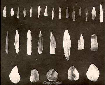
Some Mesolithic lithic implements found during an excavation in the 1920s
The earliest recorded find is a Palaeolithic flint flake (NHER 6221). The Kelling Heath Mesolithic flint-working site (NHER 6246) was excavated in 1924 to 1926. Large numbers of Mesolithic worked flints and waste from flint working were recovered from in-situ deposits. Some of the flints are now thought to date to the Upper Palaeolithic. Other Mesolithic worked flints (NHER 6247, 20603, 39490 and 39492), a core (NHER 13330), an awl (NHER 29807) and blades and cores (NHER 14378) have also been found. Large numbers of Neolithic worked flints have been recovered. At one site twenty to thirty axeheads (NHER 6199) were recorded. Single axeheads (NHER 6223, 6225, 6302, 13884, 14792 and 43197) have also been recovered. A scraper (NHER 11247) and a blade (NHER 24508) have been found.
A complete Beaker period pot (NHER 6227) was found on Kelling Heath. This may have come from Gallows Hill (NHER 6201), a Bronze Age bowl barrow. This barrow is the largest, and probably the earliest, of a group of bowl barrows that form a cemetery to the north east of Salthouse Heath (NHER 6201). The group consists of at least nine round barrows. The smaller barrows to the south are arranged in two parallel lines, through which a trackway runs. There are also many other Bronze Age barrows and possible barrows (NHER 6248, 6249, 11300, 11885, 17478, 17479, 18100, 18816, 36412, 27984 and 27168) in the parish. Bronze Age finds include a Neolithic to Bronze Age axe hammer (NHER 6224), an Early Bronze Age chisel or axe (NHER 43197) and a piece of Bronze Age to Iron Age pot (NHER 17390). Metal detecting has recovered an Iron Age mount (NHER 30248).
A Roman building (NHER 6228) was discovered in 1957 and was excavated by Gresham's School in the late 1970s and early 1980s. The excavations revealed two almost parallel ditches and a collapsed wall of wattle and daub sitting on a mortared flint foundation. The cropmarks of a probable Roman enclosure (NHER 17480), a field system (NHER 27951) and trackways (NHER 27743) can be seen on aerial photographs. Metal detecting has recovered a variety of Roman finds including coins (NHER 6229, 6237 and 32145) and brooches (NHER 44084, 30248, 33048 and 43197). A hoard of thirty three Roman coins (NHER 29805) dating to around AD 314 were found by a metal detectorist on two occasions. A second hoard (NHER 43197) of thirty two coins also dating to the 4th century AD was also recovered by a metal detectorist. Metal detecting has also found a late 4th to 5th century buckle (NHER 29807).
Many Saxon objects have been recorded by metal detectorists. These include a number of Early Saxon personal items that may come from a single burial (NHER 34655). Early Saxon brooches (NHER 33048, 29807, 33446 and 33045), a mushroom-shaped mount (NHER 30248) and a gusset plate (NHER 33446) have been recovered. The gusset plate was used to hold together material at the wrist. Middle Saxon finds include two pins (NHER 29807 and 30249), brooches (NHER 30248 and 33274) and coins (NHER 32281 and 33045). Late Saxon finds include a trefoil brooch (NHER 33272), a coin (NHER 34657) and a stirrup strap mount (NHER 29807). The stirrup strap mount depicts an animal head with arms projecting from both sides and a hand grips the outer frame. The arms are a most original feature not found on any other published mount. The arcading in St Mary’s Church (NHER 6242) may be Saxo-Norman.
The rest of St Mary’s Church (NHER 6242) mostly dates to the 13th and 15th centuries. The chancel is 19th century but it contains a small but sumptuous 15th century Easter Sepulchre. The font dates to around 1500 and is inscribed with the names of the donors William and Beatrice Kelling. The two separate buildings medieval and Georgian Kelling Hall (NHER 6230) are now in ruins. Parts of the medieval moated structure were excavated in 1986 and 1987 when a turret stair, garderobe and possible forebuilding were recorded. Earthworks of banks, terraces and a possible hollow way related to this site (NHER 29587) have been surveyed. A second hollow way (NHER 38371) can be seen on aerial photographs. A group of linear ditches, possibly representing medieval field boundaries (NHER 27744) have also been identified in this manner.
Medieval finds include coins (NHER 32280, 33274 and 34660), a stirrup (NHER 34657) and a harness pendant (NHER 44082). Metal detecting recovered a seal matrix (NHER 34655) inscribed in Latin 'Seal of Richard Frank'. A medieval enamelled and gilded heraldic buckle plate fragment (NHER 33047) was also found. The base of a medieval pilgrim's ampulla or flask (NHER 30248) depicting a crowned W was recorded. This comes from the medieval pilgrimage centre at Walsingham.
The sites of a post medieval kiln (NHER 6239) and two limekilns (NHER 6240 and 29527) are marked on old maps. A hydraulic ram (NHER 6241) used to pump water has been located. The post mill (NHER 15818) was last used in 1904. Earthworks of ridge and furrow (NHER 38646) can be seen on aerial photographs. A signal station on Telegraph Hill (NHER 6303) may date to the Napoleonic War. The Midland Great Northern Joint Railway (NHER 13584) runs through the parish and was reopened in the 1970s as the North Norfolk Railway. 19th century stations, signal boxes, bridges and embankments survive in a number of locations.

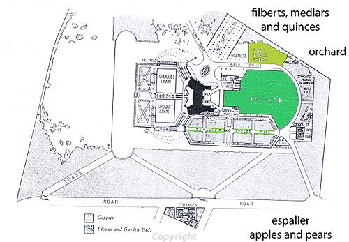
Plan of the Arts and Crafts garden at Voewood including an orchard area.
Voewood (NHER
6489) was built in 1903 to 1905 by E.S. Prior for Rev. Percy R. Lloyd using flint and carrstone from the surrounding grounds to face the concrete structure. The building is in Arts and Crafts style and is the largest example of a house with Prior's butterfly-shaped plan. There is a formal garden (NHER
37581) with pebble and brick walls. Kelling Hall (NHER
24101) another butterfly-shaped building was built by Edward Maufe for Sir Henri Deterding, chairman of Royal Dutch Petroleum and Shell, in the early 20th century.

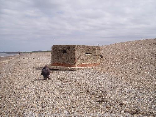
A World War Two pillbox that was once part of a wider network of defensive structures. (© NCC.)
During World War One and Two much of the area was used for training troops. Practice trenches (NHER
38406 and
38414) and trench complexes (NHER
38418) were dug on the heath during World War One. Earthworks (NHER
35551) were also erected. During World War Two a temporary airfield (NHER
23129) was created alongside the railway as part of a one day pre D-Day Dakota exercise by the United States Army Air Force. This was later criss-crossed with lines of upcast and ditches, possibly to make the airfield unusable to the enemy. Defensive structures such as pillboxes (NHER
32482 and
38493), barbed wire defences (NHER
38382), gun emplacements (NHER
38384) and anti-aircraft batteries (NHER
38404) were erected. The heath was also used for training and trenches (NHER
32512) and weapons pits (NHER
38378) were dug. A number of craters (NHER
38386) that pock mark the heath may have been created by enemy fire or during training. Very similar features can be seen on RAF aerial photographs taken in the 1940s of Muckleburgh Hill.
Weybourne Camp (NHER 11335) originally started out as a temporary summer camp for the Anti Aircraft Division of the Territorial Army in 1935. At first the majority of the camp consisted of wooden and tented structures, although in 1937 it was decided to make the camp permanent and more fixed structures and defences were erected. The camp closed in 1959. During World War Two the camp was surrounded by a perimeter anti tank ditch and defended by a system of gun emplacements and barbed wire. The interior of the camp consisted of groups of Nissen huts and barracks and other military buildings. The cliff top to the north was covered by a line of heavy anti-aircraft guns and batteries, slit trenches and pillboxes.
Megan Dennis (NLA), 12 June 2006.
Further Reading
Brown, P. (ed.), 1984. Domesday Book, 33 Norfolk, Part I and Part II (Chichester, Philimore)
Knott, S., 2006. ‘St Mary, Kelling’. Available:
http://www.norfolkchurches.co.uk/kelling/kelling.htm. Accessed: 12 June 2006.
Mills, A.D., 1998. Dictionary of English Place Names (Oxford, Oxford University Press)
Neville, J., 2004. ‘Norfolk Mills – Kelling post windmill’. Available:
http://www.norfolkmills.co.uk/Windmills/kelling-postmill.html. Accessed: 12 June 2006.
Rye, J., 2000. A Popular Guide to Norfolk Place-names (Dereham, The Larks Press)