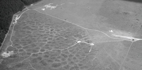
 NHER 5640, Grimes Graves Neolithic Flint Mine. Copyright NCC. Photo by D.A. Edwards.
The Brecks has rich archaeological potential, yet there is a lack of good landscape data to inform management decisions. This means that features are at risk because their presence, location and significance aren’t known or fully understood.
A major priority for the area in terms of local heritage protection is, therefore, to enhance baseline knowledge of heritage assets within forestry and heathland areas. Aerial photography plays a key role in this.
The Brecks from Above project has enabled the Norfolk Historic Environment Service to promote greater understanding of the use of aerial photography in gathering information on the historic Breckland landscape and archaeological remains in the area.
The project has included:
-
An outreach and training programme on Aerial Archaeology in the Brecks.
-
Digital access to 1000 historic aerial photos of sites in the BNG scheme.
-
Opportunities to participate in identification, interpretation and recording activities. This included training volunteers to identify potential archaeological sites from Air Photos, including Google Earth Images, and to submit their own online records.
Find Out More