This Parish Summary is an overview of the large amount of information held for the parish, and only selected examples of sites and finds in each period are given. It has been beyond the scope of the project to carry out detailed research into the historical background, documents, maps or other sources, but we hope that the Parish Summaries will encourage users to refer to the detailed records, and to consult the bibliographical sources referred to below. Feedback and any corrections are welcomed by email to heritage@norfolk.gov.uk
Hockwold cum Wilton is a large parish in the southwest of the county. The parish encompasses various different types of landscape; the fens in the west, the chalk uplands to the north and the river valley of the Little Ouse to the south. The two villages of Hockwold and Wilton are now barely distinguishable from one another, and the two villages have been treated as one since at least the 16th century. Hockwold comes from the Old English meaning ‘wood where hocks or mallows grow’, and Wilton means ‘farmstead or village where willow trees grow’.
Hockwold has an exceptionally diverse and rich variety of archaeological records. This is due, in part, to the efforts of Frank Curtis and the Fenland Survey. Curtis collected a large amount of early material from the fields, and excavated several sites as they were revealed by the erosion of the peat. These sites might otherwise have been destroyed without being recorded, and have greatly enhanced our picture of settlement in the Fens during prehistory. The Fenland Survey was an extensive fieldwalking project undertaken over a wide area in the 1970s and 1980s, and revealed many new sites and finds.
It is important to remember that the distinctive landscape of the Fens has not always been there. The Fenland Basin had been formed by the end of the Pleistocene and for several thousand years was covered by forest, and peat growth was restricted to damp areas close to rivers and streams. Peat formation began after the basin was flooded by the sea, creating a landscape of damp salt marshes drained by a complex network of channels.
The earliest finds recovered from the parish are Palaeolithic flint handaxes (NHER 5303, 5304, 5305 and 5306), and an Upper Palaeolithic or Mesolithic flint working site (NHER 5307) has been identified; over seven hundred flints were recovered in 1964.
During the Mesolithic period peat formation was restricted to the channels of streams and rivers like the River Little Ouse. Mesolithic groups were attracted to the sandhills in the valley of the River Little Ouse, and several Mesolithic sites (NHER 20054, 20232 to 20235 and 22322) have been recorded along the edge of the river and the roddon. No evidence of Mesolithic settlement has so far been recorded within the Fenland basin, as the forests did not offer as many resources as the river valleys to hunter-gatherer groups. During the Early Neolithic period settlement began to gradually move away from the river valley towards the modern fen edge (NHER 20232, 19818, 5320 and 14734).
From the Late Neolithic period to the Early Bronze Age the encroachment of the North Sea laid down deposits of clay over the Fenland Basin. As the sea receded a landscape of salt marshes and mudflats appeared, drained by a complex series of channels. These channels gradually silted up, eventually forming roddons; silt ridges that are visible above the level of the surrounding land. These conditions encouraged the formation of peat that gradually blanketed the Basin, and created the distinctive landscape of the Fens. During the Late Neolithic to Early Bronze Age settlement in Hockwold expanded to the area of the modern fen edge, as well as around the roddon of the Little Ouse. Some settlement sites, for example on the sandhills around Decoy Fen (NHER 20054) would have been surrounded by water for at least part of this period. More intensive activity occurred during Beaker period, and a number of Beaker sites (NHER 5308, 5332 and 24866) were excavated and identified by Frank Curtis in the 1960s as the peat eroded. The sites of several Beaker huts (NHER 5317 and 5333), or shelters, were discovered, including a shelter that was edged with a series of birch stakes that probably acted as a windbreak (NHER 5324). Several other Late Neolithic to Early Bronze Age or Beaker sites were identified during the Fenland Survey (NHER 5309, 5310, 5394, 5423, 20054, 20233, 20235 and 22523) along the fen edge and the Little Ouse roddon (NHER 22315, 22317 and 22322). Over fifty scatters of prehistoric pot boilers have been recorded in Hockwold, clustered along the fen edge. Although they are not closely datable, the majority of these sites have been interpreted as possibly dating to the Late Neolithic to Early Bronze Age. Pot boiler sites, or burnt mounds, are usually interpreted as cooking sites. It is unclear whether the prehistoric settlement sites identified in the parish were permanent or seasonal. Early communities were probably using the lower ground to pasture summer livestock and then moving them to higher ground over winter.
A number of Bronze Age round barrows (NHER 4991, 4992, 32594, 33453, 33454, 33455, 33456, 33457, 33604 and 33625) survive as upstanding earthworks, and several ring ditches (NHER 12810, 29036, 29699, 30284, 30322 and 30855) are visible as cropmarks on aerial photographs. These monuments are all confined to the north and east of the parish on the higher land above the fen. No Middle or Late Bronze Age settlement sites have been identified in the fenland areas of the parish, perhaps due to the lack of identifiable pottery rather than its absence from the archaeological record. A number of Bronze Age metal objects have been recovered from the parish, some of which have been dredged from the Little Ouse. These include socketed axeheads (NHER 5370, 5371, 5384, 5422 and 5468), flanged axeheads (NHER 5372, 5385 and 17541), palstaves (NHER 5186, 5369, 5382, 16020, 19025, 28787 and 35693), a razor (NHER 5368), daggers (NHER 5386, 5387 and 5388), spearheads (NHER 5376 and 5389), knives (NHER 5378 and 13930), rapiers (NHER 5379, 5381 and 16545) and swords (NHER 16018, 22921 and 25142). A handled pottery cup (NHER 12434) and a bone point made from a horse bone (NHER 15087) have also been found, as well as a Late Bronze Age hoard (NHER 5316) and a Late Bronze Age penannular ring (NHER 37663) found by a metal detectorist. The ring is wrapped with strips of gold, creating a striped effect.
No Iron Age settlement sites have been identified in Hockwold, although other settlements have been recorded elsewhere along the fen edge. An excavation in Sluice Drove in 1962 revealed a chalk floor from a small building (NHER 5394) probably dating to the Iron Age. An excavation by the NAU in 2002 at Moor Drove revealed a series of Iron Age boundary ditches (NHER 36961) that were in use over a long period of time. Metal detecting and fieldwalking has recovered a number of Iron Age finds, including gold and silver coins (NHER 5316, 22707, 5351, 23339 and 25784), brooches (NHER 5465, 12580, 16022 and 19832), a toggle (NHER 5464), a terret (NHER 14737) a weaving comb (NHER 11445) and fragments of pottery (NHER 5338, 5467, 14726 and 14737).

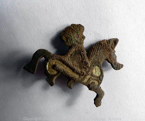
A Roman horse and rider brooch from the site of a Roman settlement and temple. (© NCC.)
During the Roman period there was intense industrial and domestic activity along the fen edge. The archaeological evidence from Hockwold is particularly rich, including some spectacular finds! The site of a substantial Roman settlement (NHER
5587) near Leylands Farm is known from cropmarks, excavations, fieldwalking evidence, and metal-detected finds. Aerial photographs of the site show the cropmarks of an organised settlement, with a regular pattern of roads and numerous buildings. In the 1950s several diadems and a crown were discovered on the site after ploughing, prompting an excavation which revealed a possible temple building. Coins, brooches and votive objects were recovered from the immediate area, as well as another diadem, which was found inside the area of the building. Two pewter hoards have also been found on the site, and another has been found nearby (NHER
5588). The finds from the site suggest that that the temple was connected with the cult of Attis and Cybele.
In 1962 the remains of a Roman temple (NHER 5367) were discovered in Sawbench Wood by Frank Curtis. An excavation revealed a complex of narrow ditches and timber framed buildings with chalk floors. Fragments of priests head-dresses and other metal artefacts were found on the site, as well as urned cremations that were buried below a deposit of red deer antlers. A large Roman rural settlement (NHER 5316) was excavated near Grange Farm in the 1960s, before the construction of the cut-off channel from Denver to Hockwold. The excavation recovered a large amount of Roman building material, coins, pottery and metal finds.

A Roman zoomorphic stag brooch from Hockwold-cum-Wilton. (© NCC.)
In between these two areas of settlement are the sites of individual Roman buildings, and the cropmarks and earthworks of field systems and enclosures. In the 1930s a Roman building (NHER
5351) was excavated close to the Little Ouse, revealing a floor surface as well as roof tiles and other building materials. Fieldwalking has revealed the site of another possible Roman building (NHER
35099). Roman building material, window glass and a large number of pottery fragments were recovered from the southern half of the field. A Roman timber-lined well (NHER
29922) was excavated in 1993, but the exact location of the well is unknown. The well contained animal bones, Iron Age coins and a number of Roman pottery vessels. A Roman field system and track way (NHER
5455) are visible as cropmarks on aerial photographs in Ennefer’s Field to the south of the village. In 1971 three Roman urned cremations were found underneath a mound, and Iron Age and Roman pottery has also been found on the site. A series of ditched and banked cropmark enclosures (NHER
13039) are probably also part of a Roman field system. The earthworks of Roman enclosures and other features (NHER
5461) can be seen on aerial photographs, close to the earthworks of the medieval village of Hockwold (NHER
5357). Roman pottery, coins and casting waste have been recovered from the site.
The Roman finds recovered from the parish are some of the impressive and evocative pieces found in Norfolk. The Hockwold Treasure (NHER 5395) was found in 1962, and consists of seven silver cups and handles with relief and carved decoration. The cups were found crushed and in pieces, and have been restored by the British Museum where they are on display. Several hoards have been found in the parish, including two pewter hoards (NHER 5588 and 5587), a hoard of Roman cauldrons and other vessels (NHER 5465) found by a metal detectorist in 1974, coin hoards (NHER 5587 and 18451), and a possible hoard of iron objects including a coulter and an adze (NHER 33367). A pewter plate with incised decoration (NHER 16273) may be associated with one of the pewter hoards found in the area. A cosmetic palette or mortar (NHER 20516), with a bull’s head at one end and a bird’s head at the other, is one of the largest and most elaborate examples recorded in the country so far. Other Roman finds include a statuette of Mercury (NHER 5351), an unusual copper alloy vessel with a hinged lid attached by loops (NHER 15102), a copper alloy hinge from lorica, or body armour (NHER 16272), an annular ring with snake’s head terminals (NHER 13822), two miniature votive axes (NHER 20178), several brooches (NHER 5380, 5406, 5436, 5464, 32877 and 34277), including two decorated with a sunburst pattern (NHER 30952 and 31758), coins (NHER 5402, 5462, 13860, 21968, 23415, 29327, 34936, 36156 and 37117), fragments of pottery (NHER 5399, 5400, 5404, 5405, 5444, 13823, 14728 and 14737), a seal box lid with decorated with blue enamel (NHER 5466), a skillet with traces of enamel decoration (NHER 29169) and two pairs of tweezers (NHER 12716, 37344).
The eastern boundary of the parish runs along the Fossditch (NHER 1089), a large linear earthwork that probably dates to the Early Saxon period, although other linear earthworks in Norfolk have been identified as Iron Age. The earthwork was probably part of a line of defence controlling a particular territory. The site of an Early Saxon cemetery (NHER 19576) has been identified by metal detecting. A fabulous Early Saxon gold cross-shaped mount decorated with garnets was found in 1850 (NHER 5303). Metal detecting has also recovered a number of brooches (NHER 5351, 16869, 24435, 31757 and 37117), a wrist clasp (NHER 23415), a girdle hanger (NHER 5316), a spearhead (NHER 13039), a fragment of pottery (NHER 5455), and a loom weight (NHER 36993). Middle Saxon pottery (NHER 17102 and 32779), a silver coin and a strap end (NHER 23415) have been found. Late Saxon pottery (NHER 5357), a silver ingot (NHER 5455), and a hoard of silver coins (NHER 13039) have been found during metal detecting and fieldwalking. A Late Saxon iron sword (NHER 15748) and an iron spearhead (NHER 36202) have been found during dredging.

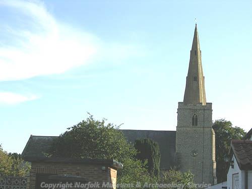
St Jame's Church, Wilton. (© NCC.)
The Domesday Book records that in 1086 Hockwold was held by William of Warenne, and was part of a holding, or manor, that included land in Feltwell and Castle Rising. The holding has enough woodland to support 200 pigs, and 17 beehives. Wilton was also held by William of Warenne, and was a relatively larger and more valuable holding in comparison with Hockwold. Wilton had 6 fisheries, 200 sheep and was worth £10.
St James’ Church (NHER 5470) in Wilton dates to the 14th century, and contains 15th century pews with pierced backs and arm rests with carved figures. In the churchyard there are several early 18th century carved headstones, and a headstone to Elizabeth Wetherall dated 1675. Wilton Cross (NHER 5411), which stands in Church Lane, is a medieval stone cross with an octagonal brick base. Another medieval cross base (NHER 13386) stands in the grounds of Hockwold Hall (NHER 5472).

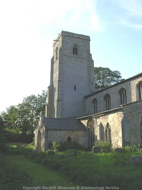
St Peter's Church, Hockwold. (© NCC.)
St Peter’s Church (NHER
5471) in Hockwold dates back to the early 14th century and has an excellent example of a hammerbeam roof with carved figures. In the churchyard is an early 18th century headstone with a carved skull. The medieval village of Hockwold was much larger than the present village, and an area of earthworks (NHER
5357) in Peacocks Field represents the former extent of the village. The earthworks include a medieval moat, fishponds, enclosures and hollow ways. A ditched causeway (NHER
33701) is visible as an earthwork on aerial photographs near Manor Farm, and may be the remains of a medieval road. Medieval finds from the parish include part of a 15th century bone comb (NHER
5414), a hoard of 500 silver coins (NHER
5415) and a lead pilgrim badge of St Andrew (NHER
23340), the only example to be found outside London and Scotland.
College Farm (NHER 17106) is an early 16th century timber framed house that originally had an open hall. Upper floors were inserted in the 17th century and the house has an 18th century façade. Gainsborough House in South Street (NHER 22529) is an early 17th century timber framed house, with an ornate staircase and parlour cell. Wilton Farmhouse (NHER 22554) is an early 17th century flint and brick house that has a carved Jacobean frieze in the main bedroom. Hockwold Hall (NHER 5472) is a 17th century house with a two-storey porch tower, a battlemented octagonal tower and early 19th century Gothick windows. The stables, walled garden and summerhouse all date to the 18th century. The Red House (NHER 43899) has been converted from two 18th century houses and has arched windows and a thatched roof.
During the post medieval period the Fens were drained and converted to arable use. In Hockwold, a wind pump (NHER 5447) drained the land around Decoy Fen and Redmore Fen. The wind pump is shown on Bryant’s map of 1826, and was later replaced by an engine house that has now been demolished. Another wind pump at Redmore Fen was replaced by a steam driven pumping-engine in 1863 (NHER 41062). Wilton Bridge (NHER 12500) was a suspension bridge erected in 1829. In the 19th century this was replaced by a brick and iron bridge, and this has since been replaced with a modern bridge. During the 19th century there were limekilns near Whitedyke Farm (NHER 14729) and Feltwell Road (NHER 31769), and brick kilns near Brick Kiln Farm (NHER 17105).
A World War Two pillbox (NHER 18878) with an unusual domed roof stands near the cut-off channel.
Sarah Spooner (NLA), 11 April 2006.
Further Reading
Brown, P. (ed.), 1984. Domesday Book: Norfolk (Chichester, Phillimore)
Gurney, D., 1986. Settlement, Religion and Industry on the Fen-edge; Three Romano-British Sites in Norfolk (East Anglian Archaeology, No. 31)
Healy, F., 1996. The Fenland Project Number 11: The Wissey Embayment: Evidence for Pre-Iron Age Occupation Accumulated Prior to the Fenland Project (East Anglian Archaeology, No. 78)
Mills, A. D., 1998. Dictionary of English Place-Names (Oxford, Oxford University Press)
Norfolk Federation of Women’s Institutes, 1990. The Norfolk Village Book (Newbury, Countryside Books)
Rye, J., 1991. A Popular Guide to Norfolk Place-names (Dereham, Larks Press)
Silvester, R. J., 1991. The Fenland Project Number 4: The Wissey Embayment and the Fen Causeway, Norfolk (East Anglian Archaeology, No. 52)
Unknown, unknown. 'Hockwold-cum-wilton'. Available:
www.hockwold.info. Accessed: 11 April 2006.