This Parish Summary is an overview of the large amount of information held for the parish, and only selected examples of sites and finds in each period are given. It has been beyond the scope of the project to carry out detailed research into the historical background, documents, maps or other sources, but we hope that the Parish Summaries will encourage users to refer to the detailed records, and to consult the bibliographical sources referred to below. Feedback and any corrections are welcomed by email to heritage@norfolk.gov.uk
Diss, which comes from the Old English meaning ‘place at the ditch or dike’, is a large parish in the south of the county. Diss itself is a thriving market town, with a wealth of medieval and post medieval buildings, around the Mere, a six acre lake in the centre of the town. The parish has an elongated shape, stretching out to the north along The Heywood, a large area of former common land, as well as several former greens, including Walcot Green and Westbrook Green.

The mere in Diss is one of the town's most famous landmarks. (© NCC)
A number of prehistoric flint implements (NHER
39526 and
21172) have been found throughout the parish, including a Mesolithic or Neolithic pick (NHER
7919) and Neolithic axeheads (NHER
7921,
7922,
10928 and
10929). Bronze Age copper alloy axeheads (NHER
7923 and
17716) and a copper alloy knife (NHER
21607) have also been found. In 1773 two possible Bronze Age cremation burials (NHER
11005) were found underneath St Mary’s Church (NHER
11005), but no prehistoric settlement sites have yet been identified. The Mere itself is also an important part of the archaeological record of the parish. The Mere is one of the deepest inland lakes in the country, and hidden within the layers of mud are individual pollen grains dating back to the prehistoric period, which archaeologists can use to study the physical environment of the area over thousands of years.
Although no definite Roman settlement has been identified in the parish, it seems likely that the settlement of Diss began to grow up around the Mere in the Roman period. In 1939 workmen building a new branch of Woolworth’s discovered timbers from a Roman building (NHER 7932) on the edge of the Mere. It has been suggested that the building may have been a wharf, or a villa. Roman coins (NHER 7925, 10977, 14541 and 15085), pottery (NHER 7924, 21039, 21172 and 35981) and other metalwork, including brooches (NHER 7927), have been found within the modern town of Diss, as well as scattered throughout the rest of the parish. The site of another Roman villa (NHER 7926) is marked on an Ordnance Survey map of the parish.
Early Saxon brooches (NHER 13704 and 34383), a fragment of Middle Saxon pottery (NHER 21170), a Middle Saxon gold pendant (NHER 34383), and two Late Saxon spearheads (NHER 7930) are the only Saxon finds to have been recorded in the parish. In the Domesday Book, Diss is listed under Suffolk, and seems to have been a fairly small settlement, but it was a valuable one, and held rights of soke over one and a half hundreds. A church is also mentioned in Domesday Book, and St Mary’s Church (NHER 11005) is thought to stand on the site of a Late Saxon church, although no architectural evidence of an early church has survived.

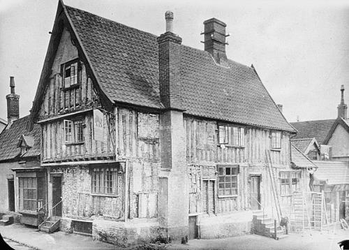
Dolphin Public House, Diss.
Courtesy of Norfolk County Council Library and Information Service.
During the medieval period the cloth and wool trade made Diss wealthy and prosperous. St Mary’s Church is a large parish church, dating mainly to the 14th century, with 15th century work, and 19th century restoration. The size and decorative detail of the church reflect the prosperity of Diss in the late medieval period, as do the number of medieval and early post medieval buildings that have survived in the town. One of the most famous residents of Diss was John Skelton, the Tudor poet laureate, and tutor to Henry VIII. St Nicholas’ Chapel (NHER 12056) was built in the 15th century, but was dissolved during the Reformation, and although the site of the chapel is known, no standing remains have survived. 1 Mere Street (NHER 12022) is a late 15th century timber framed house, with an ornately carved angle post. 134 and 135 Victoria Road (NHER 18821) is also a late 15th century timber framed house, which may have had an open hall. Dolphin House (NHER 12021) is a 16th century timber framed building, with an unusual first floor open hall, which may have been used by a merchant to display his goods, as at Dragon Hall in Norwich. A number of 16th century buildings have survived, including The Grove (NHER 32778), Lime Tree House (NHER 12023), the Greyhound Hotel (NHER 18474) and 2 Fair Green (NHER 12059). Fair Green (NHER 32774) itself has been the site of a market for 800 years. A large number of 17th century buildings are still standing in the town, and although many have been altered in the 18th and 19th centuries, many original features have survived.

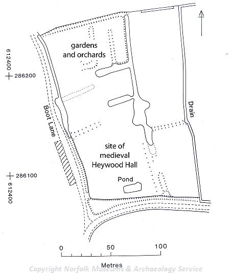
Earthwork plan of Heywood Hall, Diss. (© NCC)
A number of wealthy farms were situated during the medieval period, and the sites of fourteen medieval moats are known in the Heywood. Diss is in the heart of the large belt of clay that runs through central Norfolk and Suffolk, so although Diss has a large number of moats, they were relatively cheap to construct and maintain in this area. Moats fulfilled a vital social function in proclaiming wealth and status to the neighbours, and many of the large farmhouses in the parish are surrounded by a moat. Dairy Farm (NHER
1041) and Chestnut Tree Farmhouse (NHER
10995) are both 16th century farmhouses and Heywood Manor (NHER
10940) is a 17th century timber framed manor house. Heywood Hall (NHER
10941) is an early 17th century house, within a medieval moated complex, within which is the site of a probable earlier house, as well as the earthworks of garden and orchard boundaries, and fishponds. Many of the medieval moats in the parish no longer have any buildings within them, and survive as earthworks in the landscape (NHER
10944,
10988,
10993,
10998,
10999,
18534 and
36288) or as cropmarks on aerial photographs (NHER
10987). Medieval pottery (NHER
21037,
21041,
21042,
21044,
21046 and
21047) has been found by fieldwalking scattered throughout The Heywood.
During the post medieval period, the wealth generated from the cloth and wool trade diminished, which may be why many of the splendid timber framed buildings were not rebuilt in the 18th and 19th centuries, when large brick townhouses were more fashionable than timber framing. Diss continued to grow however, attracting a large number of industrialists and professionals, such as bankers. Its situation on the main road from Norwich to Ipswich, and later the main railway line to London, encouraged the growth of industries such as malting, and two malting complexes (NHER 30598 and 36043) are still standing in the town. In 1848 a public park (NHER 33462) was created in Park Field, which became known as Diss Arboretum. Several grand houses and shops were built in the town in the 18th and 19th centuries, including the Manor House (NHER 28918), an 18th century brick mansion, Park Hotel (NHER 30597), and 127 to 135 Victoria Road (NHER 40081), which is an imposing 19th century terrace, with the central house constructed in the shape of a triumphal arch. The Cedars (NHER 33463) is a late 18th century house, with the only example of a detached landscape park within a town in Norfolk. The landscape park (NHER 33463) was created across the road from the Cedars, in the late 18th or early 19th centuries.
A World War Two pillbox (NHER 16002), built close to the railway line, has now been restored as a memorial to the Home Guard. A Royal Observer Corps post (NHER 34612) was constructed in the 1960s during the Cold War on the outskirts of the town, and the building retains some of its original paint.
Sarah Spooner (NLA), 1st November 2006.
Further Reading
Brown, P. (ed.), 1984. Domesday Book: Suffolk (Chichester, Phillimore)
Diss Town Council, 2005. 'diss-online'. Available:
www.diss.co.uk. Accessed: 1st November 2006.
Mills, A.D., 1998. Dictionary of English Place-Names (Oxford, Oxford University Press)
Rye, J., 1991. A Popular Guide to Norfolk Place-names (Dereham, Larks Press)