This Parish Summary is an overview of the large amount of information held for the parish, and only selected examples of sites and finds in each period are given. It has been beyond the scope of the project to carry out detailed research into the historical background, documents, maps or other sources, but we hope that the Parish Summaries will encourage users to refer to the detailed records, and to consult the bibliographical sources referred to below. Feedback and any corrections are welcomed by email to heritage@norfolk.gov.uk
Redenhall with Harleston parish contains the two villages of Redenhall and Harleston. Redenhall village itself is the earlier, listed in the Domesday Book, whereas Harleston existed by the time of the Domesday Book, but is largely a medieval creation set up during the 13th century. The name Redenhall may derive from the Old English words for ‘reedy nook’, unsurprising considering the number of drains that cross the parish, the southern border of which is formed by the River Waveney.

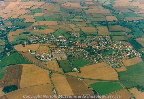
Harleston from the air. (© NCC)
The name ‘Harleston’ has a most complex history. Although it is possible that the name derives from the Old English name Heoruwulf, a local legend states the name is actually derived from
Harolds Stone (NHER
11081), a roughly rectangular rock of about 2m x1m x 1m which is situated in a pedestrian walkway between The Thoroughfare and Church Street in Harleston. It is said that this stone, also referred to as 'King Harold's mounting block', is the stone on which Harold stood to apportion land.
The parish itself is situated just west of Wortwell parish, and east of Starston and the Pulham parishes, and shares their roughly rectangular shapes. This group of parishes sits on the southern border of Norfolk, and has undergone some boundary changes during the last few centuries. Previous to 1885 a parish referred to as Mendham existed in the area currently occupied by Wortwell, and contained land both in Suffolk and Norfolk. The Norfolk part of this parish, Mendham-in-Norfolk, was transferred in 1885 to the new parish of Wortwell, which was created from a previously existing hamlet. At this time Redenhall with Harleston was also enlarged with land previously in Mendham.
The earliest signs of human occupation are quite numerous, with a number of examples of worked flint and potboilers scattered across the parish at some nineteen sites, an unusually high number. Of particular interest are a Neolithic arrowhead (NHER 29122), a fragment of Neolithic quern stone (NHER 28208) and a small, unfinished, Palaeolithic handaxe (NHER 28628).
Strangely, despite the unusual number of worked flints recovered from the parish, there have been no objects confirmed to date to the Bronze or Iron Ages. Of uncertain but probably Bronze Age are three groups of cropmarks of ring ditches; two situated just north of Harleston (NHER 19648, NHER 11710), and one 1.3km away to the northeast (NHER 20031).
However, there have been a number of recovered objects dated to the Roman period. Despite there being no evidence of Roman buildings in this parish Roman sherds have been recovered from three sites in the north of the parish within 1 km of each other (NHER 29120, NHER 25813 NHER 29123). Other finds include a small number of coins (NHER 12771, NHER 31938, NHER 35422), and a brooch (NHER 31946), however of particular interest is a hoard of 144 Roman copper alloy coins that may potentially date to the late 5th century (NHER 11098). The hoard contains a number of mid fifth century coins, which has exciting implications for discussions on the extent to which society changed after the ‘end’ of the Roman Empire in Britain in AD 410. At least one of the later coins also shows stylistic links with the Early Saxon sceattas, which may also present new evidence for the discussion of early England.
Unfortunately there is very limited evidence for Saxon occupation of the parish, and the only objects recovered from this period are a brooch (NHER 31946) and one Late Saxon coin. The entry for Harleston in the Domesday Book is very brief, however Redenhall is mentioned in more than one place and is clearly large and prosperous by the end of the Saxon period. The lack of objects recovered from these periods is therefore more likely to be indicative of the low quantity of investigative work undertaken in the parish, rather than an actual paucity of evidence.
Evidence for the medieval period is more common, with a large number of medieval pottery sherds (NHER 16123, NHER 25813, NHER 15527), a few metal objects (NHER 29123, NHER 31946) and coins (NHER 35422) recovered. A large number of these have been recovered near the A143, which cuts the bottom of the parish east to west, but this is related to the activities of a field survey program undertaken in the early 1980s before the construction of the Harleston bypass. Of particular interest are a fragment of a medieval cauldron (NHER 15528), and a medieval German coin of Frederick II (NHER 33201).
The medieval period is also the first to give us a large number of surviving monuments. Like the nearby parishes of Pulham St Mary and Pulham Market there are a number of possible moated sites (NHER 11057, NHER 13066), sometimes but not always associated with manor houses. Abbey Yards (NHER 11063) is one of these sites, with water-filled sections still remaining, although there are no extant buildings of the same period. Also with possible medieval moats are the site of Hawker’s Hall (NHER 11100) and Coldham Hall, the buildings of which date to the 18th century (NHER 11062). Other sites include late medieval to early post medieval pits in the centre of Harleston (NHER 22962).
This parish is also similar to its neighbours Starston and the Pulhams in that it has a large number of historic buildings, in fact there are over 130 buildings in this parish listed by English Heritage, and they make up over two thirds of all historic sites. One of the most interesting of these is the parish church (NHER 11104), which despite the large size and success of Harleston as early as the medieval period, remained in Redenhall village.

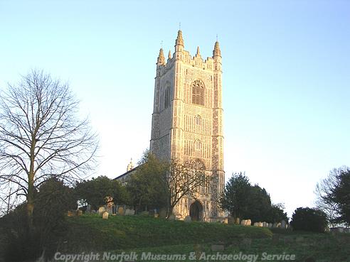
St Mary's Church, Redenhall. (© NCC)
The church, dedicated to St Mary, may be the site of a Saxon minster but the present building was begun in the 1460s and largely paid for by the De la Poles, one of the richest families in East Anglia during this period. As a result of more recent parish boundary changes, only the tower of this rather imposing church now remains in the parish, the majority of the building falling into the neighbouring parish of Wortwell, with which it is ecclesiastically united.
Shotford deserted settlement should also be noted, although as Shotford Heath is beyond the southern boundary of the parish, the settlement may lie in Suffolk. All that remains is the 17th century Hall and barn (NHER 11918), which is believed to stand on the site of the settlement.
Other sites of particular interest include Caltofts in Harleston (NHER 12476), dated to 1460 but built on the foundations of an earlier house of 1375. There are also the remains of a number of medieval hall houses inside later buildings. One example of this is Nos 16 and 18 Old Market Place, Harleston, which contains a 14th or 15th century raised aisled hall (NHER 14405), and a similar late medieval hall forms part of Nos 4, 6 and 8 London Road (NHER 30306).
By the post medieval period, building in Harleston had expanded rapidly, and buildings of the 17th and 18th century line both sides of The Thoroughfare, Broad Street and Old Market Place, and spreading into the small courts on either side. Almost all of Harleston’s 17th and 18th century buildings are timber framed, but a large number of them have been given brick skins in the 18th or 19th centuries, and so at initial glance appear to have a later date. Harleston’s obvious success was to the detriment of its parent village, Redenhall, which has only a handful of historic buildings and is a fraction of modern Harleston’s size.

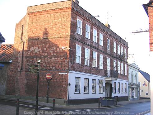
The Swan Hotel, an undecorated 16th or 17th century timber framed inn. (© NCC)
Of particular interest is The Swan Hotel (NHER
12475), a 16
th or 17
th century inn with carriage arch, as well as Dove House (NHER
24392), a large complex of buildings dating from the 17
th century and situated on the southern edge of the town. Also of note is The Old House, Old Market Place (NHER
33885), which originated in the 16
th century, and the public conveniences on Exchange Street (NHER
40928) which although they appear to be of 19
th century brick, are in fact a 17
th or 18
th century timber framed building.

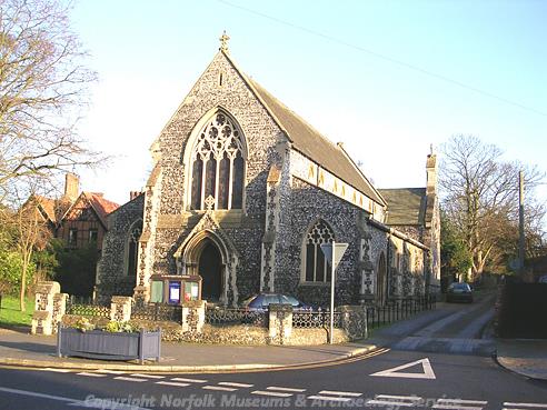
St John the Baptist's Church, Harleston. (© NCC)
Due to its traditionally subordinate position to Redenhall, Harleston didn’t gain a church of its own until 1872, when the church of St John the Baptist was built. Although it lacks a tower, the church is constructed from regular Victorian knapped flint with stone trim, and despite its relative youth manages to maintain a suitably murky, medieval tone. Inside, most of the original stained glass commissioned from the O'Connors remains, as well as some lovely 1980s work depicting the local landscape and the church's patron saint.
Outside the village, 16th century Shotford Bridge (NHER 11070) serves as a reminder of the now extinct village. Evidence of the industrial past of the parish is also visible in 19th century brick kilns (NHER 29121), as well as the sites of several mills (NHER 16396, NHER 12474), and the former maltings on Station Road (NHER 44712) and malthouse on Recreation Walk (NHER 47859).
Also deserving a mention is the site of Lushbush, at Three Cross Ways, half way between Redenhall and Harleston. In 1813 Mary Turrel was buried here after having poisoned herself during investigations into the murder of an infant found in a pond. It is said that 'A vast concourse of people assembled to watch the stake being driven through her heart', and that this stake then grew into Lush's Bush, which gives the area its name.
Despite this large number of buildings, the number of recovered objects that have been dated to the post medieval period is small. Pottery sherds are the most common find from this period (NHER 15527, NHER 15529, NHER 16632), as well as metal objects such as buttons or fittings (NHER 15528) and coins (NHER 31946, NHER 35422).
This parish also contains a number of more recent monuments, including two aircraft crash sites, one dating to World War One (NHER 13672) and one to World War Two (NHER 13673). In addition there are two of the common type 22 World War Two pillboxes, one situated about 100m east of Redenhall Road (NHER 32721) and one near to 13 London Road (NHER 32722), although this one has been partially demolished. The parish also contains the site of a former Royal Observer Corps post, in fields southeast of Harleston (NHER 35394), which was in use during the Cold War.
Ruth Fillery-Travis (NLA), 17 January 2007.
Further Reading
Hunt's Directory of East Norfolk with Part of Suffolk, 1850.
Knott, S., July 2005. 'St Mary, Redenhall’. Available:
http://www.norfolkchurches.co.uk/redenhall/redenhall.htm. Acccessed: 17 January 2007
Knott, S., June 2005. ‘St John the Baptist’. Available:
http://www.norfolkchurches.co.uk/harleston/harleston.htm. Acccessed: 17 January 2007
Mortlock D. P. & Roberts, C. V., 1981. The Popular Guide to Norfolk Churches No. 2, Norwich, Central and South Norfolk (Acorn Editions)
Morris, J. (General Editor), 1984. Domesday Book, 33 Norfolk, Part I and Part II (Chichester, Phillimore & Co)
Neville, J., 2004. ‘Harleston Towermill’. Available:
http://www.norfolkmills.co.uk/Windmills/harleston-towermill.html. Acccessed: 17 January 2007
Pevsner, N., 1997. The buildings of England: Norfolk 2: Northwest and South (London, Penguin Books)
Rye, J., 1991. A Popular Guide to Norfolk Place Names (Dereham, The Larks Press)