This Parish Summary is an overview of the large amount of information held for the parish, and only selected examples of sites and finds in each period are given. It has been beyond the scope of the project to carry out detailed research into the historical background, documents, maps or other sources, but we hope that the Parish Summaries will encourage users to refer to the detailed records, and to consult the bibliographical sources referred to below. Feedback and any corrections are welcomed by email to heritage@norfolk.gov.uk
Hindringham is a large parish in the north of the county, close to the coast. The settlement pattern of the village is fairly dispersed, with several farms on the edge of the village. Hindringham comes from the Old English meaning ‘homestead of the people living behind the hills’.
The parish has been occupied since the prehistoric period, and several concentrations of prehistoric pot boilers (NHER 20164, 24910, 24911, 24912, 25850, 28006, 28560, 28561, 28562 and 37012) have been revealed during fieldwalking. Fieldwalking has also recovered other prehistoric flints (NHER 25157, 25670, 25993, 28003 and 31876), a quern (NHER 15118), flint flakes (NHER 25007, 25659, 28002, 28006 and 28469) and flint scrapers (NHER 25007, 25659, 28001).
A large amount of Mesolithic flint implements, found during fieldwalking and metal detecting, suggest that a site near the church was occupied during the Mesolithic period (NHER 24909). Other Mesolithic artefacts (NHER 25157, 25999, 31164 and 41826), including a flint blade (NHER 25998), a stone mace head (NHER 28844), and a Mesolithic or Neolithic flint axehead (NHER 25672) have been found. Neolithic flint finds include an axehead (NHER 2094), an adze (NHER 25271), a laurel leaf (NHER 28377), a pick (NHER 28468) and other flint implements (NHER 25850, 25999 and 31164) collected during fieldwalking. Activity in the parish continued in the Bronze Age, and socketed axeheads (NHER 2078, 25474), a palstave (NHER 2095 and 23243), a rapier (NHER 25157), chisels (NHER 28378 and 28380) and swords (NHER 28844 and 29135) have been found, as well as a spearhead with wood surviving in the socket (NHER 25454).
Although no specific Iron Age settlement sites have yet been identified, it is clear that settlement in the parish continued to develop. Iron Age pottery (NHER 25773, 28007, 28377, 28378, 29133, 31164 and 41826), brooches (NHER 25773, 29133 and 29135) and coins (NHER 25773), including a gold coin (NHER 25671) have been found by fieldwalking and metal detecting.

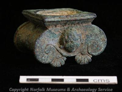
A remarkable example of a Roman candleabrum in the shape of an Ionic capital. (© NCC.)
By the Roman period the picture of settlement becomes much clearer, and several Roman settlement sites (NHER 25773, 28005, 28470 and 29133) have been identified to the west of the modern village. The course of a possible Roman road (NHER 2087) is visible as an earthwork on the parish boundary and on aerial photographs. Extensive fieldwalking and metal detecting over several years have recovered fragments of Roman pottery (NHER 2088, 24909, 24910, 25157, 25998, 25999, 28001, 28006, 31375, 28377 and 33792), tile (NHER 25670), coins (NHER 20164, 25671, 25672, 25993, 25994 and 28635), brooches (NHER 25474, 25850, 28007, 29135, 31876 and 42694) and other metal finds (NHER 24909, 28378, 28380, 31164, 25659 and 25008). These finds include fragment of a buckle decorated with dolphin heads (NHER 25007), a silver leopard's head from a larger vessel (NHER 28005) and a remarkable example of a candelabrum in the form of an elaborate Ionic capital (NHER 29133).

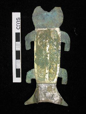
An unusual Early Saxon mount in the shape of a stylised fish. (© NCC.)
Fragments of Early Saxon pottery (NHER 24909, 25071, 25157, 28005, 28844 and 41826) and a number of brooches (NHER 25007, 25008, 25474, 25670, 25672, 25773, 25999, 28378, 28470, 28844, 29135, 31876 and 42558) and other metal finds (NHER 25670 and 29134), including an unusual mount in the shape of a fish (NHER 29134) have been found in the fields surrounding the village.
During the Middle and Late Saxon period the focus of settlement was in the fields around the church (NHER 24909 and 25071), and a large amount of Middle and Late Saxon coins, pottery and metal finds have been recovered by metal detectorists. The finds include brooches, strap ends and a hoard of Late Saxon silver ingots. Middle Saxon pottery and metal finds (NHER 25157, 25271, 25474, 25670, 25671, 25672, 28003, 28007 and 31876), a Middle Saxon coin (NHER 25773), Late Saxon pottery (NHER 25008, 25671, 25672, 25773, 25994, 25997, 25998 and 33792) and metal finds (NHER 25007, 25009, 25474, 25659, 28005 and 28380) including a Borre style brooch (NHER 29739) have also been found in the area around the village.
Hindringham is first recorded in the mid 11th century will of Ǽthelmær, the bishop of Elmham. In the Domesday Book Hindringham is recorded as several valuable manors, with a mill, beehives and woods.

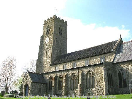
St Martin's Church, Hindringham. (© NCC.)
St Martin's Church (NHER 2110) dates mainly to the 14th century with 15th century alterations. The church contains a unique example of a 12th century wooden carved chest, decorated with rosettes and arches. Three medieval moated sites are known in Hindringham. The site of Coldham Hall (NHER 2103) is to the southeast of the village on Coldham Corner. There are now no traces of the Hall itself, although part of the medieval moat survives, as well as masonry that may have been part of a medieval bridge. Old Godfrey’s Hall (NHER 2102) was a 16th century hall within a medieval moat. The hall was demolished in the 19th century, and a barn containing reused blocks of masonry now stands on the site. Hindringham Hall (NHER 2090) is a 16th century house surrounded by a medieval moat. The Hall is probably built on the site of a medieval manor house, and a group of medieval fishponds are visible as earthworks close to the moat. The bridge across the moat dates to the 16th century and some sections of 16th century garden walls also survive.
A pond to the south of the site of Coldham Hall (NHER 2103) is probably the remains of the ditched boundary of a medieval common. Medieval earthworks (NHER 17243), including fishponds, have been reported on Bale Road. In 2000 a watching brief carried out by the Norfolk Archaeological Unit revealed two medieval pits at Primrose Farm. The pits were underneath a post medieval cobbled surface, probably a yard or a track.

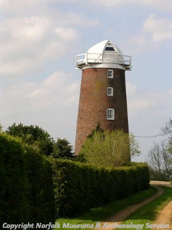
Lower Green Mill, Hindringham. (© NCC.)
Grange Farm (NHER 33213) dates back to the 16th or 17th centuries, with extensive 19th century alterations. Blue Tile House (NHER 43825) dates to the 17th century, and has a mid 18th century barn nearby (NHER 43824). Waterloo Farmhouse (NHER 21056) is a 17th century flint and brick farmhouse with a 19th century porch. Church Farmhouse (NHER 43826) is a late 17th century lobby-entrance house. Crossfield Farmhouse (NHER 43827), Grove Farmhouse and barn (NHER 43829 and 43830) and Lower Green Farmhouse and barn (NHER 43831) all date to the 17th century. Field House (NHER 43828) is an 18th century farmhouse with an enclosed courtyard to the north containing ranges of service wings. Godfrey’s Hall (NHER 33854) is a mid 19th century house, built in a Greek Revival style. The hall contains a fireplace taken from the earlier hall (NHER 2102) that stood nearby. Two windmills (NHER 15201 and 15202) are marked on Faden’s map of 1797. Lower Green Mill (NHER 2106) is a 19th century brick tower mill that has been converted into a house. Upper Mill (NHER 15825) is also a 19th century mill, only the base of which is still standing.
A World War Two pillbox (NHER 16129) stands at the junction of Wells Road and Great Snoring Road. Another pillbox (NHER 30785) that was used by the Home Guard stands near Grove Farm. The sites of two other pillboxes in the village were at the crossroads near Home Farm (NHER 30784) and opposite the village post office (NHER 30789).
Sarah Spooner (NLA), 4 April 2006.
Further Reading
Brown, P. (ed.), 1984. Domesday Book: Norfolk (Chichester, Phillimore)
Mills, A.D., 1998. Dictionary of English Place-Names (Oxford, Oxford University Press)
Norfolk Federation of Women’s Institutes, 1990. The Norfolk Village Book (Newbury, Countryside Books)
Rye, J., 1991. A Popular Guide to Norfolk Place-names (Dereham, Larks Press)