This Parish Summary is an overview of the large amount of information held for the parish, and only selected examples of sites and finds in each period are given. It has been beyond the scope of the project to carry out detailed research into the historical background, documents, maps or other sources, but we hope that the Parish Summaries will encourage users to refer to the detailed records, and to consult the bibliographical sources referred to below. Feedback and any corrections are welcomed by email to heritage@norfolk.gov.uk
Fring is a small parish in the northwest of Norfolk. Located near the source of the Heacham River just inland of Sedgeford and Snettisham it is north of Shernbourne and south of Docking. The modern village is a relatively small settlement clustered around the church. It is recorded in the Domesday Book as an outlier of Sedgeford parish. The name Fring derives from Old English meaning 'place of Frea's people'. This placename evidence and the appearance of the village in the Domesday Book suggests the settlement was in place by the Late Saxon period. Although there are only twenty five archaeological records for the parish recorded in the NHER they seem to suggests that Fring was an area of importance much earlier than the Late Saxon period.
The earliest finds date to the Palaeolithic period. A square-shaped flaked flint axe (NHER 1658) was found in 1902. It has been interpreted as Palaeolithic but other archaeologists have disagreed and suggest it is Neolithic. A Palaeolithic 'disc' (NHER 11478) is less controversial. This was found in Fring and is now in the British Museum. Other prehistoric worked flints, including flint flakes (NHER 28754), are harder to date and can only be recorded as prehistoric. Similarly a shaft hole implement (NHER 37255) can only be dated to the prehistoric period. Several possible Bronze Age ring ditches (NHER 1659, 12157, 43328, 43329 and 43331) visible on aerial photographs are easier to identify. These are most likely to be the remains of Bronze Age burial mounds. Other Bronze Age finds include three Bronze Age awls (NHER 11775, 33395 and 23001). Most of the prehistoric finds, however, date to the Iron Age. The area seems to have been a focus of activity at this date, particularly in the Late Iron Age. Carefully located metal detecting surveys carried out over twenty years have recovered a large number of finds. At one site (NHER 1659) there may have been a focus of activity. Unfortunately the presence of later Roman and Early Saxon features at the site (see below) makes it very difficult to interpret the nature of the Iron Age activity. At least two Late Iron Age hoards have been recovered from the parish at other locations.

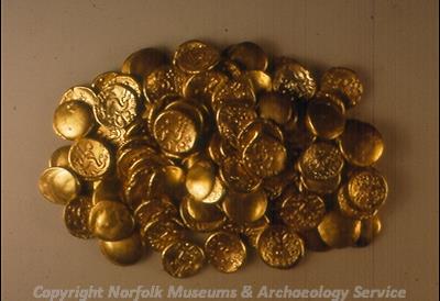
A hoard of gold Iron Age stater coins. (© NCC.)
A hoard of 173 gold Iron Age coins (NHER
1661) made in France were found on the site of a later Roman villa. A second hoard of over 200 silver Iron Age coins (NHER
25758) was found in a pottery container sealed with a linen or hemp cloth. A third hoard of over 2000 silver Iron Age coins is reported but the exact location and nature of this discovery is unclear. Despite this uncertainty the number and wealth of the Iron Age finds from the area suggest it was an important focus in the Late Iron Age period.
The presence of the Peddar's Way (NHER 1289), a Roman road, through the west part of the parish seems to have influenced the pattern of Roman settlement in the area. A tessellated pavement excavated near the road between 1780 and 1800 was investigated further in the 1950s when 2nd to 4th century AD pottery fragments and roof tile were found. The building has been identified as a Roman villa (NHER 1661). A second complex can be seen on aerial photographs. A square enclosure is internally divided into three parts. In each internal part cropmarks of simple buildings, including a hexagonal structure, can be seen. Metal detecting on this site has recovered a large number of Iron Age and Roman finds and it has been interpreted as a possible Roman villa and/or temple complex (NHER 1659). The absence of building material on the site has led to the suggestion that that buildings were constructed of timber or possibly clay. Another site visible on aerial photographs has been interpreted in the past as a Roman road (NHER 11775) although archaeologists now prefer to call it an undated linear feature. Other Roman objects have been found across the parish including Roman coins (NHER 1078, 1660 and 23393), pottery fragments (NHER 25758), a quern (NHER 1625) and brooches (NHER 1626, 11775 and 33394).
One of the Roman sites described above was also used in the Early Saxon period. The large number of Early Saxon metal finds, including brooches and personal ornaments, found here identify it as the site of an Early Saxon inhumation cemetery. The boundaries of this cemetery are unknown and burials cover at least two NHER records (NHER 1659 and 23001). Two other Early Saxon brooches have been found within the parish at separate locations. Part of an Early Saxon cruciform brooch (NHER 11261) and an unusual Early Saxon brooch (NHER 28754) were both found by a metal detectorist. The unusual brooch may have been imported.

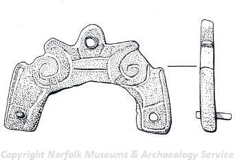
A Viking mount from Fring. (© NCC.)
Several Viking style objects have also been recovered. Two Viking mounts (NHER
11775) and the arm of a Viking trefoil brooch (NHER
33627) are recorded. A Late Saxon stirrup mount (NHER
11775), a fragment of Late Saxon pottery (NHER
1078) and a Late Saxon hooked tag (NHER
25758) have also been found. Despite the discovery of a number of lovely Saxon objects from the parish there are no clear concentrations of finds. The pattern of settlement is therefore difficult to identify, but it is possible that it lies under the modern village.
It appears that Fring may have been a more important area in the Iron Age, Roman and Early Saxon periods than in the medieval period. There are far fewer records for medieval objects and it appears that the settlement pattern probably mirrored that of the small modern village. All Saints' church (NHER 1693) was built in the 14th century and provided a focus for the medieval village. It contains some lovely 14th century wall paintings. Records suggests that there was a cell of the Norwich priory in the churchyard although no sign of it can be seen now. The site of a Benedictine cell (NHER 1631) is also recorded and cropmarks visible on aerial photographs of the site include buildings and an enclosure. Another religious structure, the medieval cross (NHER 14486) is recorded on an estate map of the Le Strange family but can no longer be seen. Medieval strip fields (NHER 43330) can be seen on aerial photographs. Medieval pottery (NHER 28347) including a complete jug handle of the 13th to 14th century (NHER 1627), a book clasp (NHER 33627) and a decorated rectangular medieval buckle (NHER 11775) have also been found.
There are no records for buildings or monuments of the post medieval period. This does not mean that there are no interesting structures however, simply that they haven't been recorded in the database. Fring Hall was built in 1807 and was burnt down and rebuilt in the 20th century. The building of the hall and park caused the redesign of the village (NHER 43438) in the 19th century. White House on the Bircham Road is an early 19th century gault brick building. In addition to these buildings post medieval coins (NHER 1078 and 11775) and a token (NHER 1078) and metal finds including an openwork hooked tag (NHER 33395) and a thimble (NHER 37255) provide evidence for continued activity.
The most recent archaeological record is the site of a World War Two plane crash (NHER 1659). A German bomber was shot down here by four Spitfires. The site was excavated and recorded in 1981. The Hall may have been the location of a military camp (NHER 43326) during this period.
Megan Dennis (NLA), 14 December 2005.
Further Reading
Brown, P. (ed.), 1984. Domesday Book, 33 Norfolk, Part I and Part II (Chichester, Phillimore)
Gregory, T., 1982. 'Romano-British Settlement in West Norfolk and on the Norfolk Fen Edge' in Miles, D. (ed.), 1982. The Romano-British Countryside. Studies in Rural Settlement and Economy. Part II. British Archaeological Reports. British Series. 103 (II) (Oxford, BAR)
Mills, A.D., 1998. Dictionary of English Place Names (Oxford, Oxford University Press)
Pevsner, N. and Wilson, B., 1999. Buildings of England. Norfolk 2. North-west and south (London, Penguin Books)
Rye, J., 2000. A Popular Guide to Norfolk Place-names (Dereham, The Larks Press)