This Parish Summary is an overview of the large amount of information held for the parish, and only selected examples of sites and finds in each period are given. It has been beyond the scope of the project to carry out detailed research into the historical background, documents, maps or other sources, but we hope that the Parish Summaries will encourage users to refer to the detailed records, and to consult the bibliographical sources referred to below. Feedback and any corrections are welcomed by email to heritage@norfolk.gov.uk
The mid-Norfolk parish of Hingham is situated about ten miles west of Norwich, its name coming from the Old English for ‘high homestead’. The parish is an ancient settlement, and as early as AD 925 is recorded as the property of King Athelstan, grandson of Alfred the Great. Its population, land ownership and productive resources are extensively recorded in the Domesday Book of 1086.
The earliest evidence of human activity in the parish comes in the form of Mesolithic flint flakes (NHER 2941) and Neolithic flint axeheads (NHER 2944, 2946, 2947, 9069 and 15594). A stone axehammer (NHER 2948) could be either Neolithic or Bronze Age. The Bronze Age may have left fragmentary traces of the earliest structures in the parish. Aerial photography in 1976 noted the cropmarks of one or possibly two ring ditches (NHER 12811) southwest of Gurney's Manor. These are the surrounding ditches of circular burial mounds that have since been flattened by farming, invisible on the ground. Several Bronze Age copper alloy axeheads have been found (NHER 2950, 2951 and 2952), but the only evidence of Iron Age activity is a harness fitting (NHER 25626).
No traces of any Roman structures survive, though there was an uncorroborated report of a mosaic floor being found in the 1990s (NHER 32990). However, there have been quite a number of Roman finds, including pottery fragments (NHER 2953), a puddingstone quern (NHER 2954), coins and brooches (NHER 2982, 34591, 19432 and 40284), a furniture fitting (NHER 17032) and a hairpin (NHER 33863). Only two Saxon objects have been found to date, a brooch (NHER 25673) and a rare Early Saxon gilded copper alloy wrist clasp (NHER 34592).
The medieval period has left the parish with its oldest surviving building, St Andrew’s Church (NHER 2979). This is a big church, over fifty metres long with a huge west tower that is a landmark for miles around. The building is notable in that it was virtually all constructed at the same time, having been built in the latter years of Remigius of Hethersett, rector here from 1319 to 1359. Later additions and alterations culminated in an enthusiastic Victorian restoration. All the windows are large, but the east window is enormous, one of the biggest in England, and is entirely filled with early 16th century glass imported from Germany in 1813. The interior is mainly 19th century and striking. The soaring nave is crowned by a fine hammerbeam roof of 1872, and the roofs of the aisles have winged angels. Probably the most impressive feature inside is the massive 15th century red stone memorial to Thomas, Lord Morley and his wife on the north wall of the chancel. A bust of American President Abraham Lincoln was placed in an alcove in the north aisle in 1919. He himself was not from the village, but some of his ancestors lived here before emigrating two hundred years before his presidency.
Only two other medieval buildings survive, though much altered. The Barclays Bank site in the Market Place (NHER 16139) is a timber framed building, its chimney stack inserted in the 16th century and upper floor in the 17th century. It was refaced in about 1800. 18 Bond Street (NHER 14264) is a late medieval thatched timber framed house, probably originally two dwellings. Other buildings of the period have not survived, but have left a footprint in the form of their surrounding moat. Some can still be seen from the ground (NHER 2962, 2981, and 22132), others only being visible from the air as cropmarks (NHER 13037). Traces of a possible former medieval settlement at NHER 33856 in the west of the parish can be seen as low earthworks.
Medieval finds include coins (for example NHER 34591 and 25627), a deanery seal (NHER 12493), pottery fragments (NHER 17159), a signet ring (NHER 31687), a seal matrix (NHER 25627 and 37658), buckles and thimbles (NHER 17032 and 25627).

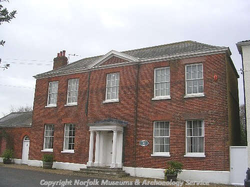
The mid 18th century facade of Quorn House, Hingham, with three bays and a slightly advanced central bay with a pediment. (© NCC.)
There are a great number of post medieval buildings of interest, far too many to mention in this summary. To the west of the church is Attleborough Road, on which is the Manor House (NHER
17139), with a 17th century core and an early 19th century front with a columned porch. To the north is Fairlands, with Unicorn House (NHER
14262) at number 12. The main block of this house is 19th century, but with a 16th or 17th century timber framed rear wing.
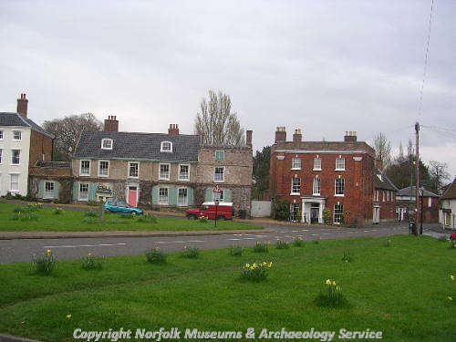
To the east of the church is the Market Place, which on its eastern side has one of the finest groups of Georgian buildings in Norfolk. At number 12, Admiral’s House (NHER 35373) is an early 18th century building, possibly with an earlier core, its name coming from Admiral Sir Philip Wodehouse, who once lived there. Also there is the great Beaconsfield House (NHER 14259), a three storey 18th century building framed between two giant pilasters, Little London House (NHER 14258) at number 11 and Quorn House (NHER 14255) at number 10, both mid 18th century houses with central columned porches. Southernwood (NHER 14254), a 17th century house, was home for twenty years to Field Marshal Edmund Lord Ironside.

The Admiral's House, Hingham (with a grey slate roof), was once the home of Admiral Sir Philip Wodehouse. (© NCC.)
The north side of the Market Place has a group of 18th and 19th century houses and shops, the most prominent of which is the White Hart Hotel (NHER
43840) at number 3. This is a 17th century timber framed building, rebuilt in the 1770s to benefit from the opening of the turnpike, and later given an early 19th century façade. Its columned porch has a white hart standing on top.
Bond Street runs north out of the Market Place, and here can be found Mansion House (NHER 14263), a mid 17th century house in chequered brick with shaped gables.
Among a number of buildings of interest away from the centre of Hingham itself is Gurney’s Manor (NHER 2980). The earliest part of this house is from about 1600, with later extensions of about 1700. However, the most imposing part is the grand Georgian east façade.
In the southeast of the parish on the Deopham Road stands a 19th century watermill (NHER 12495), on the site of earlier mills. It was remarkable in that, rather than being fed by a river or stream, the millpond was supplied by a number of natural springs. It has now been converted to a handsome residence. There was also a brick tower windmill (NHER 12494) to the southeast of Hingham village, built in 1829, and originally six storeys high. Only the bottom four storeys of the tower remain. Other industrial sites, marked on old maps, have not survived, like two saw pits (NHER 12146 and 12490) and a brick kiln (NHER 15951), and are now mainly built over. However a brickworks and kiln site at NHER 12491, although covered in modern housing, still has its Gothic style lodge.
Two substantial buildings in the parish have gone. Hingham Rectory (NHER 12342), a large 18th century house set in extensive grounds, stood to the west of the church. Derelict for many years, it was demolished in the 1980s to make way for a housing development, although its gate and walls (NHER 41206) remain, together with the coach house and stable (NHER 41207). Hingham Hall (NHER 2978) was a hall of 1759. It had been largely demolished by 1978, and the site is now also under a modern housing estate.
More recent monuments are also recorded. An earthwork mound west of Sea Mere (NHER 32847), has in recent years become known as Vikings Grave, but was in fact a shooting butts for volunteer soldiers during the Boer War. In World War One, the Royal Flying Corps had a grass aerodrome in the parish from 1916 to 1917 (NHER 39346), but its exact location is not known. In World War Two, a pillbox (NHER 32439) stood in the field to the west of Gurney’s Manor, part of the anti invasion defences of 1940. It was demolished after the war, and no trace remains today. Also from World War Two is Deopham Green Airfield (NHER 4260), in the south of the parish, straddling the boundary with Great Ellingham. This was home to the 452nd Bombardment Group of the United States 8th Army Air Force, equipped with B17 Flying Fortresses. Closed and sold after the war, several runways, hangars (one with contemporary murals) and an air raid shelter remain.
The most historically recent entry for the parish is a Royal Observer Corps Cold War underground monitoring post (NHER 35395), still in reasonable condition by the side of Seamere Road. In use from 1957 to 1969, it was one of a network of such posts, designed to monitor fallout in the event of a nuclear attack.
This summary is intended very much as an overview, particularly given the large number of architecturally interesting buildings in the parish. Those wishing to dig a little deeper (and those whose houses have not been mentioned) should consult the full records.
Piet Aldridge (NLA), 25 May 2006.
Further Reading
Brown, P. (ed.), 1984. Domesday Book, 33 Norfolk (Chichester, Phillimore & Co)
Knott, S. 2005. 'St Andrew, Hingham'. Available:
http://www.norfolkchurches.co.uk/hingham/hingham.htm. Accessed: 25 May 2006.
Norfolk Federation of Women’s Institutes, 1990. The Norfolk Village Book (Newbury, Countryside Books)
Pevsner, N. and Wilson, B., 1999. The Buildings Of England: Norfolk 2: North-West and South (London, Penguin Books)
Rye, J., 1991. A Popular Guide to Norfolk Place Names (Dereham, The Larks Press)