This Parish Summary is an overview of the large amount of information held for the parish, and only selected examples of sites and finds in each period are given. It has been beyond the scope of the project to carry out detailed research into the historical background, documents, maps or other sources, but we hope that the Parish Summaries will encourage users to refer to the detailed records, and to consult the bibliographical sources referred to below. Feedback and any corrections are welcomed by email to heritage@norfolk.gov.uk
The parish of Hainford lies about five miles to the north of Norwich in the eastern part of Norfolk. Its name comes from the Old English for ‘hedged enclosure by the ford’. The parish has a long history of human occupation, and was certainly well established by the time of the Norman Conquest, its population, land ownership and productive resources being recorded in the Domesday Book of 1086.
The earliest evidence of human activity in the parish consists of prehistoric, but otherwise undateable flint flakes (NHER 7977 and 28177) and a knife (NHER 8012). No Palaeolithic or Mesolithic flint tools have as yet been found, and the next evidence of activity is quite a number of Neolithic flints, including chipped axeheads (NHER 7647, 7981, 7983 and 13851), polished axeheads (NHER 7978 and 7982), a leaf arrowhead (NHER 14664) and a blade (NHER 42544). A barbed and tanged flint arrowhead (NHER 42544) may be Neolithic, but could be Bronze Age. There has been some suggestion of a Neolithic long barrow on the north boundary of the parish (NHER 7642), but this earthwork feature has also been interpreted as a Bronze Age barrow and medieval archery butts, so any classification is unlikely to be definitive, and the most that can be said is that part of the earthwork is likely to be a medieval boundary bank. Apart from this rather confusing earthwork, no structural remains have been identified from the Bronze Age, and the only finds from the period are a flint blade (NHER 7980) and part of a copper alloy spearhead (NHER 28434). Iron Age finds are similarly scarce at the moment, consisting of possible pottery fragments (NHER 22834) and a curious lead model ‘Celtic’ head (NHER 30188), though this is more likely to be Roman.

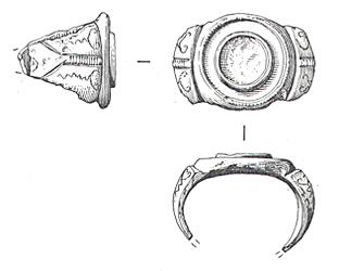
Drawing of a Roman ring from Hainford. The circular bezel in the centre of the ring originally held a gem. (© NCC. and S. White.)
The Roman occupation from AD 43 has left evidence of the earliest structures in the parish. Of course, nothing visible remains of these, but concentrations of Roman finds and building materials in an area can indicate their former presence. One such concentration has been noted north of the junction between Buxton Road and Church Road (NHER 16738), where a large number of Roman finds, including coins, brooches, bricks and tiles, indicate a former building or part of a settlement. Saxon, medieval and post medieval objects recovered from the same area show that it was in use after that time as well. Part of a supposed Roman road from Brampton to Thorpe St Andrew also ran through the parish (NHER 7598), although trial excavations have revealed little evidence of this. Other Roman finds in the parish include coins (NHER 7985, 25010, 36656 and 39905), pottery (NHER 25011) and figurines (NHER 25828 and 42543).

A 9th century AD copper alloy strap end from Hainford. It depicts a zoomorphic terminal and a roughly incised human face in the frame above. (© NCC. and S. White.)
Evidence of Saxon occupation in the parish consists of brooches (NHER 1
6738,
25010 and
25775), pottery fragments (NHER
22834) and a strap end (NHER
39905).
The medieval period has left the parish with its oldest surviving building, or at least the remains of it. All Saints’ Old Church (NHER 8019), a 13th century and later building, now stands as an overgrown ruin after partial demolition in 1840, when the new church, also All Saints’ (NHER 8020) was built. The nave, chancel and south porch have gone, but the west tower still stands, topped with later battlements. The water table in the new churchyard is too high to allow for burials, so a mortuary chapel was added to the east of the old tower, and burials in the grounds continue there to this day. Aside from the earthwork NHER 7642 referred to above, there are no other medieval features in the parish, but medieval finds include coins (NHER 30188, 36656 and 39910), harness pendants (NHER 25011), buckles (NHER 33927 and 34373), a strap end (NHER 42543) and a lead pilgrim’s bottle (NHER 42545).

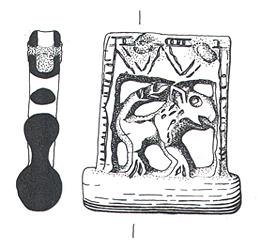
A medieval scabbard chape from Hainford. It depicts a lion in openwork. (© NCC. and S. White.)
Of the parish’s post medieval buildings, probably the earliest is Lodge Farmhouse (NHER
43091), a 17th century T shaped house, to which a west range was added in the early 19th century, then a later south porch. The Chequers (NHER
43092) is an early 18th century thatched brick pub, much altered in later years, and White Lodge (NHER
43093) is also 18th century. The early 19th century saw the construction of Hainford Hall (NHER
12270), a massive three storey brick block of a building, now in ruins and home to a large car dump. Hainford Place (NHER
43090) was built at about the same time. All Saints’ New Church (NHER
8020), built between 1838 and 1840, is a fine example of 19th century church architecture, cruciform in shape and in Early English style. A later 19th century building is Waterloo Lodge (NHER
12268), a Tudor style former lodge to Stratton Strawless Hall in the neighbouring parish.
On the northwest boundary of the parish stands a 19th century memorial stone to Stratton Masham, killed when thrown from his horse in 1838 (NHER 12267).
The most recent entries on the record relate to World War Two. Standing in trees to the east of the Poultry Farm is a type 22 concrete pillbox (NHER 32547), part of the anti invasion defences of 1940. A number of indentations in Waterloo plantation are craters left by a stick of German bombs aimed at Stratton Strawless Hall, used as a radar headquarters at the time (NHER 12269). Finally, there are two aircraft crash sites, both in the southwest of the parish. NHER 24745 is where a Beaufighter came down, and to the north, NHER 24746 is where a B24 Liberator crashed.
Piet Aldridge (NLA), 11 April 2006.
Further Reading
Brown, P. (ed.), 1984. Domesday Book, 33 Norfolk (Chichester, Phillimore & Co)
Rye, J., 1991. A Popular guide to Norfolk Place Names (Dereham, The Larks Press)