This Parish Summary is an overview of the large amount of information held for the parish, and only selected examples of sites and finds in each period are given. It has been beyond the scope of the project to carry out detailed research into the historical background, documents, maps or other sources, but we hope that the Parish Summaries will encourage users to refer to the detailed records, and to consult the bibliographical sources referred to below. Feedback and any corrections are welcomed by email to heritage@norfolk.gov.uk
The parish of Brinton is set in north Norfolk, between Gunthorpe to the west and Thornage to the east. Its name comes from the Old English for ‘enclosure of Bryni’s people’, and it is mentioned in the Domesday book as an outlier of Thornage.
Evidence of human activity in the parish goes back to the earliest times, and comes in the form of two Palaeolithic flint handaxes (NHER 34848 and 37709). Several concentrations of prehistoric but undateable burnt flint have also been found (for example NHER 33561 and 33562). Several Neolithic worked flints and a polished flint axe (NHER 11337) are the only finds from this period, and the archaeological record is so far silent on Bronze Age activity. Iron Age Brinton is represented only by pottery fragments (NHER 32044 and 33563) and a harness fitting.
Far more has come to light from the period of the Roman occupation, evidence not only of activity, but also of settlement. A dense scatter of Roman building materials at NHER 32786 marks the site of a probable building, perhaps a villa, and the earliest evidence of a building in the parish. Individual finds from the Roman period include pottery fragments (NHER 32044, 32834, 33563 and 33798), coins (NHER 32905 and 37214), brooches (NHER 33036), and part of a puddingstone quern (NHER 32842).

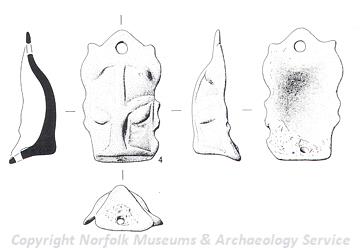
Late Saxon stirrup strap mount from Brinton. (©NCC)
The Saxon period is represented in the parish by quite a number of sites where pottery fragments have been found (NHER
3196,
32834,
33560 and
33798). Metal detecting has also recovered a gold ornament (NHER
32044), a box mount (NHER
25803), a brooch (NHER
32903) and coins (NHER
33036).
The medieval period following the Norman Conquest has left the parish with its earliest surviving monuments. There are the remains of two medieval stone crosses (NHER 3174 and 12315), which may have been preaching stations for pilgrims on their way to Binham and Walsingham Priories. There are two medieval churches in the modern parish; All Saints’, Sharrington (NHER 3205) has a 13th century nave and chancel in one, and a 14th century west tower. It originally had aisles as well, but these were demolished, although the arches to them remain. Inside, there are 14th and 15th century brasses. St Andrew’s church, Brinton (NHER 3210) may be as early as Saxon in origin (Saxon masonry was reported during restoration work in 1873), but the current building is 13th and 14th century with later alterations. The interior has some rather fine bench ends of 1544.
There is evidence of a now abandoned medieval settlement at NHER 29585, consisting of banks, enclosures and ditches. However, little is known of its history.
Individual medieval finds include pottery fragments (eg NHER 3196 and 32044), coins (NHER 24789, 28408, 29585, 32905 and 34848), buckles (NHER 24880 and 25804), a padlock (NHER 33330) and a silver spoon (NHER 37214).
Post medieval buildings that survive in Brinton include:
Sharrington Hall (NHER 3175), a 16th to 17th century building that is probably on the site of a medieval moated manor.
Old Hall Farm (NHER 15451), a 16th or 17th century farmhouse with a 17th century barn and converted granary.
Valley Farm (NHER 21003), a 17th century farmhouse with an 18th or 19th century barn.
Daubeney Hall Farm (NHER 37412), originally a house of about 1600, rebuilt in the 18th century and heightened in the 19th century.
The Grange (NHER 41275), a late 17th century house with a 19th century front, forming a T shape.
Brinton Hall and Park (NHER 33726), an 1822 hall on the site of earlier halls, and set in a historic park. In the park is a 19th century underground ice house (NHER 3204), now used as a bat sanctuary.
Turning to more modern times, the parish has two surviving World War Two pillboxes (NHER 18035 and 18572), and witnessed the crash landing of a German bomber in 1941 (NHER 15116). It also played a role in the Cold War; at NHER 35419 is a Royal Observer Corps (ROC) underground monitoring post. Opened in 1958, this was one of a network of posts covering the county whose function was to monitor fallout in the event of nuclear attack. Although closed in 1991, it is still intact. A World War Two ROC observation post stands nearby.
Pieter Aldridge (NLA), 16 November 2005.
Further Reading
Brown, P. (ed.), 1984. The Domesday Book: Norfolk (Chichester, Phillimore)
Rye, J., 1991. A Popular Guide to Norfolk Place Names (Dereham, Larks Press)