This Parish Summary is an overview of the large amount of information held for the parish, and only selected examples of sites and finds in each period are given. It has been beyond the scope of the project to carry out detailed research into the historical background, documents, maps or other sources, but we hope that the Parish Summaries will encourage users to refer to the detailed records, and to consult the bibliographical sources referred to below. Feedback and any corrections are welcomed by email to heritage@norfolk.gov.uk
Southrepps is situated very close to the coast, just 1200m away at the nearest point. It is part of the North Norfolk local government district, and contains the village of Southrepps, as well as the Lower Street and Southrepps Common areas. The western edge of the parish is cut by the Cromer Line of the East Norfolk Railway (NHER 13586), and the land is largely given over to agricultural use. The name is derived from the term ‘south repps’, the word ‘repps’ stemming from the Old English word for ‘strip’.
This parish has been part of the Norfolk National Mapping Programme, and as a result many of the features visible on aerial photographs of the region have been analysed and mapped. This has great benefits, particularly for our understanding of the prehistoric landscape, as many of the features that are visible on aerial photographs date to this period.
A good example of this are the four Bronze Age features recorded (NHER 39001, NHER 39012, NHER 38957, NHER 36490). They are all ring ditches, and interestingly are all situated in a loose grouping some 600m to the east of Southrepps village.
However, there have also been a number of objects recovered from the prehistoric period. These include a Mesolithic flakes axehead (NHER 6762), and two Neolithic axeheads (NHER 6789, NHER 6790) and a Neolithic flint adze (NHER 18857), as well as a Bronze Age copper alloy palstave (NHER 6878).
The Norfolk National Mapping Project has also recorded a number of monuments thought to date to the Iron Age or Roman periods. These include field systems (NHER 38961, NHER 36489, NHER 38895, NHER 38964), a number of linear ditches and field boundaries (NHER 38959, NHER 38964, NHER 38992, NHER 38961) as well as a possible enclosure (NHER 39024) and domestic site (NHER 36489).
Despite the fact that such a high number of monuments have been recorded, there have been hardly any objects recovered from this parish. This is largely due to the fact that there has been very little metal detector activity. As a result Roman objects, limited to a coin and brooch (NHER 35148) have been recovered from only one area, on the western edge of the parish.
There have been no objects from the Saxon period recovered, and no recorded monuments. However, there are a small number of objects from the medieval period. These include a number of pottery sherds (NHER 6792, NHER 6754) as well as a fragment of a copper alloy vessel (NHER 42539).

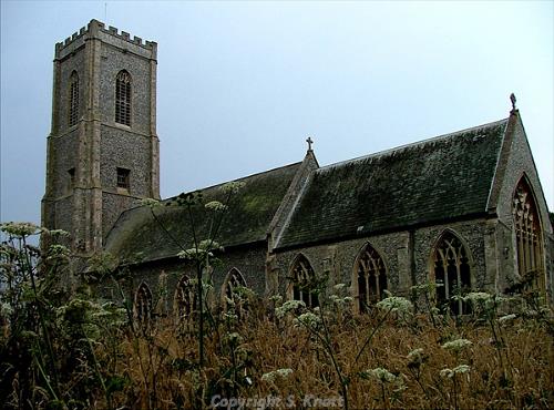
St James' Church, Southrepps. Photograph from www.norfolkchurches.co.uk (© S. Knott.)
One of the most important buildings during the medieval period was St James’ Church (NHER
6806), a large church with one of the tallest towers in the county. This impressive flint and stone church originally had aisles to the north and south, and in its hey-day may have been one of the largest in the county. The tower dates from the mid 15
th century, and is highly decorated, often thought by writers to be one of the beautiful in Norfolk.

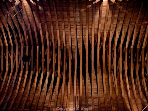
The roof of St James' Church, Southrepps. The roof was constructed in 1908. Photograph from www.norfolkchurches.co.uk (© S. Knott.)
Unfortunately the long aisles were demolished in 1791, though the arcades in the nave are still clearly visible. Restorations in 1875 and 1908 have resulted in very little surviving from the medieval period, although there are details on the mouldings on and around the priest’s door that date to around 1320. The roof beams are still fresh and warm looking, despite being installed in 1908, and seem thoroughly in keeping with a church that is obviously in active everyday use.
In addition there are several sites with medieval features, situated across the parish. These are often overlapping, but typically include field boundaries (NHER 38991), trackways (NHER 36488), enclosures (NHER 38963) and ditches (NHER 38987). Also of medieval date is Stump Cross (NHER 6791), the remains of a stone cross, situated on a crossroads on Gimingham Road. The remaining cross shaft is around 1.2m high, and sits on a square plinth, and may have stood as a parish marker or a demonstration of faith.
Post medieval buildings are more common, and of particular interest is Southrepps Hall (NHER 13451). It is a very fine mansion of 1722, which has been highlighed by English Heritage for its interior fittings and brick facade. Records of Tudor windows and beams not now visible may refer to features that were in the north wing, which may have been an original, and earlier, house.
Other buildings of interest are situated almost exclusively in Southrepps village. These include buildings such as Vernon Arms on Church Street (NHER 47728) and the 18th century Beechlands on Upper Street. Old Rectory on Upper Street (NHER 13435) is also of note, having developed from a late 17th century building with ornamental pilaster and brickwork.
There are also a large number of sites with post medieval features. These include field systems (NHER 38904), enclosures (NHER 36487, NHER 39021), trackways (NHER 38929), and boundaries (NHER 39023, NHER 38960) as well two drainage systems (NHER 38996, NHER 38995).
In addition, the site of a post mill (NHER 15427) in operation between 1774 and 1864, as well as the site of a post medieval line kiln (NHER 15847) have also been recorded. There is also a World War Two military training site (NHER 38619), part of which is situated in the very north-western corner of the parish.
Southrepps also includes part of the Cromer line of the East Norfolk Railway (NHER 13586), which was began in 1867, designed to create a route from Norwich to Cromer. It opened at North Walsham in 1874, to Gunton in 1876, and finally in Cromer in 1877, and the line is still in use today.
The line originally included the Wroxham signal box, which was built in 1900 by McKenzie and Holland, to a standard Great Eastern Railway Type 7 design, with a fifty level frame complete with internal fittings. It is currently listed by English Heritage, and is situated next to the Bure Valley Railway.
In addition the line also includes the curious Gunton Station, which was built by Lord Suffield, chairman of the East Norfolk Railway, to serve his estate. Although the larger part is now a private residence trains still stop at the station, and a number of the original features, such as the booking clerk’s windows, have been retained.
Ruth Fillery-Travis (NLA), February 2006.
Further Reading
GENUKI, Unknown. Information on Southrepps. Available:
http://www.origins.org.uk/genuki/NFK/places/s/southrepps/. Accessed: February 2006
Knott, S., August 2006. ‘St James, Southrepps’. Available: http://www.norfolkchurches.co.uk/southrepps/southrepps.htm. Accessed: February 2006
Morris, J. (General Editor), 1984. Domesday Book, 33 Norfolk, Part I and Part II (Chichester, Phillimore & Co).
Mortlock D. P. & Roberts, C. V. 1981. The Popular Guide to Norfolk Churches No. 1, North-East Norfolk (Cambridge, Acorn Editions)
Pevsner, N. 1997. The buildings of England: Norfolk 1: Norwich and North-East (London, Penguin Books)
Rye, J., 1991. A Popular Guide to Norfolk Place Names (Dereham, The Larks Press)
Southall, H., 2006. ‘A Vision of Britain Through Time: Southrepps CP’. Available: http://www.visionofbritain.org.uk/unit_page.jsp?u_id=10215821. Accessed: February 2006