This Parish Summary is an overview of the large amount of information held for the parish, and only selected examples of sites and finds in each period are given. It has been beyond the scope of the project to carry out detailed research into the historical background, documents, maps or other sources, but we hope that the Parish Summaries will encourage users to refer to the detailed records, and to consult the bibliographical sources referred to below. Feedback and any corrections are welcomed by email to heritage@norfolk.gov.uk
The parish of Ditchingham is situated in the south of Norfolk, on the border with Suffolk, its southern boundary being defined by the River Waveney. The origins of its name come from the Old English for either ‘homestead of Dicca’s people’, or ‘homestead of the dwellers at the dyke’. The parish has a long history and was certainly well established by the time of the Norman Conquest, its population, land ownership and productive resources being assessed in the Domesday Book of 1086.
The archaeological record for the parish is extensive, with evidence of human activity in every period since the Mesolithic. Scrapers, blades (NHER 10598) together with other worked flint tools (NHER 10613) have been found, and there is evidence that a Neolithic settlement site had previously been occupied by Mesolithic people (see below).

Neolithic long barrow on Broome Heath looking north. Note the figure standing beside the barrow for scale. (© NCC)
The most impressive visible monument from the Neolithic period is Broome Heath long barrow (NHER
10597), a burial mound fifty metres long and about twenty five metres wide, that may also have had ceremonial purposes. A probably later burial was excavated from the barrow in the 19th century, and Neolithic flints and pottery are still being recovered, often dug out of the mound by rabbits. A second possible small long or oval barrow, just 42m to the northeast of the Broome Heath long barrow has recently been discovered by the Norfolk National Mapping Programm (NHER
43777). An important Neolithic discovery was a rare settlement site, also on Broome Heath (NHER
10602). When excavated, Neolithic flints and post holes were found. There was also evidence of Mesolithic and Bronze Age settlement, indicating occupation of the site over a very long time. It should be emphasised that these two sites are unusual. Other evidence from the Neolithic comes in the form of flint tools such as polished axeheads (such as NHER
10598 and
10601), a knife (NHER
10598), arrowheads (e.g. NHER
10598,
10684 and
22253) and pottery fragments (NHER
10603).
It would seem that Broome Heath continued to have some ritual or spiritual significance into the Bronze Age, possibly evidenced by a group of round barrows from this period, which can still be seen. The relatively undisturbed nature of the heath has meant that, unlike most other barrow sites in Norfolk, this one has not been ploughed flat. Modern parish boundaries mean that only one of the barrows is in Ditchingham, the rest being next door in Broome. The Ditchingham barrow (NHER 10611) is about thirty metres in diameter and two metres high. Aerial photography has revealed the possible presence of another group of round barrows (NHER 11675), but these have been flattened and are visible only as ring ditches.
Bronze Age small finds from the parish include flint arrowheads (e.g. NHER 10610), a copper alloy axehead (NHER 16570) and a dagger (NHER 10612).
Iron Age finds consist of a number of coins (e.g. NHER 10613, 22254 and 29125), and brooches (NHER 10613).
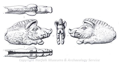
Roman folding knife handle in the form of a boar from Ditchingham. (© NCC)
Evidence from the period of the Roman occupation comes in the form of a fairly large number of coins found in the parish (e.g. NHER
10615,
22253,
22255 and
29125), and in particular a large hoard of coins found in a pottery vessel at the start of the 19th century (NHER
10614). Roman brooches (e.g. NHER
10613 and
29173) have also been recovered, as have pottery fragments (e.g. NHER
18276 and
20444) and a ring (NHER
29173). A lovely folding knife handle in the form of a boar (NHER
22255) has also been recovered. In the 19th century pottery, coins and burnt bones were discovered during building works (NHER
10684), possibly indicating a settlement and cremation cemetery. Also a Roman road (NHER
10636,
44820) is believed to have run through the parish, roughly following the course of the modern Norwich to Bungay/Wainford road between Hedingham and Wainford.
The indications are that Broome Heath still had ritual significance in Saxon times. In the mid 19th century, at least two Early Saxon cremation urns and pottery fragments were discovered, pointing to the existence of a cemetery (NHER 10628). Other Saxon discoveries in the parish include a coin (NHER 22253), brooches (NHER 10613 and 22255) and pottery fragments (NHER 10617 and 11674). A Late Saxon silver ingot recovered by metal detecting in 1990 (NHER 11674) may have been Viking loot.
The medieval period following the Norman Conquest has left the parish with its oldest surviving buildings, and probably the earliest of these is St Mary’s Church (NHER 10648), a fine parish church with a tall, elegant pinnacled west tower and good architectural features, including rare (although much repaired) original medieval figures in niches over the doorway. It was heavily but sympathetically restored several times in the 19th century, including a restoration of the south porch in 1896, paid for by the author H. Rider Haggard, who was a churchwarden. There is a memorial window to him in the northeast corner of the aisle. Inside, the font is 15th century and there are 15th century floor brasses and a unique window listing rectors of the church from 1609 to 1802. The colourfully painted chancel roof was the work of the Rector’s wife in 1862. There is also a very important World War One memorial.
Numbers 6 and 8 Pirnhow Street (NHER 20451) were originally a late 15th or early 16th century timber framed hall house, the upper floor and chimney stack added a century or so later, and the building as a whole much altered since. However, it is an unusually early survival.
Other medieval buildings, both religious and residential, have not survived. St Botolph’s (NHER 10635), a medieval chapel, was in ruins by 1588 and has since vanished, as has the manor house of Pirnhow Hall (NHER 10643). Other manors have also disappeared, but left the footprint of their surrounding moat. All Hallows Farmhouse (NHER 30687), a 16th century building, stands next to a medieval moat, and possibly replaced an earlier building there. Some post medieval houses are sited in the position of their medieval predecessor, and in Ditchingham this is the case with Tindall Hall (NHER 10640), a 17th and 18th century house, which is surrounded by the original water-filled moat of the earlier manor.
Post medieval houses of interest are too numerous to describe in detail for the purposes of this summary. However, a sample could include Tindall Hall (above); Ditchingham Hall (NHER 10641), a finely designed house of around 1715 with later additions, built for the Rev J. Bedingfeld; Ditchingham Lodge (NHER 10645), an 18th century country house set by the River Waveney; Ditchingham Park (NHER 30436), a remodelled 18th century hall set in a landscaped park; Hollybush Farm (NHER 18233), a 16th century timber framed house and Hall Farm (NHER 30686), an L shaped 18th century farmhouse. Also interesting is All Hallows Church, Pirnhow (NHER 10650), designed in simple Early English style, built and largely financed by the Rev. W.E. Scudamore (whose wife painted the roof of the chancel in St Mary’s Church) in 1863. The church was declared redundant in the 1980s and has since been converted to residential use. All Hallows Community (NHER 10644) was originally set up in the 19th century as a refuge for fallen women.
Of the industrial buildings of the post medieval period, only the 19th century silk factory (NHER 23024) survives. This later became a maltings, and was used as a U.S. army depot in World War Two. Gutted by fire in 1999, it has now been converted to residential use. Wainford Maltings (NHER 23023), an unusual early 19th century building with iron columns, has been demolished, and a windmill marked on 19th century maps (NHER 10649) has disappeared.
Windmill Green (NHER 34127) is currently the most modern entry in the record: a terrace of houses built in 1947, they are much admired for their simple design and elegant proportions.
The parish has a rich and varied history, and this summary is intended very much as an overview. Those wishing to dig a little deeper should refer to the detailed records.
Piet Aldridge (NLA), 19 January 2006.
David Gurney (NLA), 28 April 2008.
Further Reading
Brown, P., 1984. The Domesday Book, 33 Norfolk (Chichester, Phillimore & Co.)
Pevsner, N. and Wilson, B., 1999. The buildings of England; Norfolk 2: North west and south (London, Penguin Books)
Rye, J., 1991. A Popular Guide to Norfolk Place Names (Dereham, The Larks Press)