This Parish Summary is an overview of the large amount of information held for the parish, and only selected examples of sites and finds in each period are given. It has been beyond the scope of the project to carry out detailed research into the historical background, documents, maps or other sources, but we hope that the Parish Summaries will encourage users to refer to the detailed records, and to consult the bibliographical sources referred to below. Feedback and any corrections are welcomed by email to heritage@norfolk.gov.uk
Hales is a small parish in the southeast of the county. The modern village of Hales is in the far north and the pattern in the majority of the parish is one of scattered farms and clusters of settlement on the edges of Hales Green. Extensive fieldwalking has been carried out by the Hales Hall Archaeological Trust, which has revealed the former extent and pattern of settlement.
There is some evidence of prehistoric occupation, and prehistoric flints (NHER 13677, 17809, 18132, 18174, 18247, 19320, 19492, 19494 to 19496, 19498, 20365) have been found during fieldwalking throughout the parish. Late prehistoric pottery (NHER 17816, 19500, 20376), a prehistoric saddle quern (NHER 1080) and Neolithic arrowheads (NHER 18250, 19500) have also been found.
Iron Age evidence is limited, partly due to the difficulties of identifying Iron Age pottery. However, three possible settlement sites have been identified (NHER 19495, 19498 and 21515) in the north and east. All three of these sites continued to be settled during the Roman period, and fieldwalking has revealed the location of another Roman settlement (NHER 18135). Roman pottery, tiles, tesserae (NHER 17809) and coins (NHER 20365, 20368) have been found, as well as a spoon handle in the shape of a heron (NHER 21515).
Hales comes from the Old English meaning ‘nooks or corners of land’. An Early Saxon belt plate (NHER 21515) and a coin dating from the reign of Edward the Confessor (NHER 13677) were found by metal detectorists. Late Saxon pottery has also been found during fieldwalking. In the Domesday Book Hales is recorded as a fairly substantial settlement. The lost settlement of Jerpestuna (NHER 19173) is also mentioned in the Domesday Book, although its exact location is unknown.

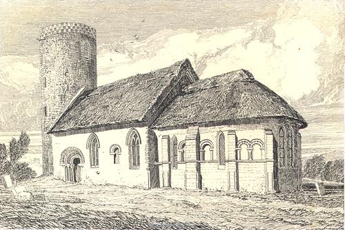
The Norman church of St Margaret, Hales.
St Margaret’s Church (NHER
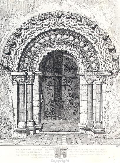
10523) is one of the most important Norman churches in the country due to the lack of later medieval alterations. The church has a round tower with circular splayed windows that bear the impressions of basketwork from their construction. The apsidal chancel is decorated with blind arcading, and the nave doorways are among the best examples in the county. The church may be associated with a nearby double moated site (NHER
11916), which was probably the site of a manor. The earthworks of possible medieval house platforms (NHER
18248) were noted close to the church in the 1980s. Hales Hall and its medieval deer park are in the neighbouring parish of Loddon, on the other side of Hales Green.

The Norman north doorway of St Margaret's Church, Hales.
Hales Green is first mentioned in 13th century documents, and has dominated the settlement history of the parish since the early medieval period. The earliest settlements on the edge of the green date from the Late Saxon and early medieval period (NHER 20365, 17816, 16855). The site of another early medieval settlement (NHER 17807) is close to a section of a curving bank and ditch which may be a former boundary. This suggests that the green may have been much larger during the 11th century, and was gradually encroached upon from the 12th century onwards. During the medieval period settlement (NHER 17188, 17812, 17809, 17816, 18132) along the edge of the green continued to intensify, reaching a high point in the 13th and 14th centuries. During the late medieval and post medieval periods most of these settlement sites were gradually abandoned. Other medieval settlement sites (NHER 18174, 18249 to 18251) have been identified around Spot Common in the east of the parish. These settlements also declined from the late medieval period, after reaching their height in the 13th and 14th centuries. Medieval pottery, coins and metal finds have been found during fieldwalking and metal detecting.
Old Farmhouse and Orchard Farmhouse (NHER 25406) is a 17th century timber framed building, now divided into two houses. The house was encased in brick in the 18th century. Hales House (NHER 43097) and The Green Farmhouse (NHER 43098) are also 17th century timber framed houses. During the 19th century a windmill (NHER 22696) was built on the outskirts of the village of Hales. The mill was derelict by the 1920s and only a small section of the base remains standing. An Ordnance Survey map of 1883 marks the site of a brickworks to the north of the modern village.
In 1940 three Meteor F8’s (NHER 13677) crashed to the north of St Margaret’s Church.
Sarah Spooner (NLA), 2 February 2006.
Further Reading
Brown, P. (ed.), 1984. Domesday Book: Norfolk (Chichester, Phillimore)
Davison, A., 1990. The Evolution of Settlement in Three Parishes in South-east Norfolk (East Anglian Archaeology, vol. 49)
Mills, A.D., 1998. Dictionary of English Place-Names (Oxford, Oxford University Press)
Rye, J., 1991. A Popular Guide to Norfolk Place-names (Dereham, Larks Press)