This Parish Summary is an overview of the large amount of information held for the parish, and only selected examples of sites and finds in each period are given. It has been beyond the scope of the project to carry out detailed research into the historical background, documents, maps or other sources, but we hope that the Parish Summaries will encourage users to refer to the detailed records, and to consult the bibliographical sources referred to below. Feedback and any corrections are welcomed by email to heritage@norfolk.gov.uk
Denver is one of Norfolk’s Fenland parishes, in the far west of the county. The parish has recently been divided by the southern bypass of Downham Market, and part of the north of the parish has been subsumed into the parish of Downham Market.
Mesolithic worked flints (NHER 24913), Neolithic axeheads (NHER 2446, 2502, 13716 and 29110), as well as other prehistoric flint implements (NHER 32754, 21475 and 21478) and pottery (NHER 21478 and 24913) have been found by field walking in the parish. Two Bronze Age palstaves (NHER 2447 and 29074) have also been found, but no definite prehistoric settlement sites can be identified.
During 1999 and 2000 the Norfolk Archaeological Unit excavated an Iron Age, Roman and Middle Saxon settlement (NHER 30228) in the park of Crow Hall, in the north of the parish. Several Late Iron Age and Roman structures and enclosures were revealed, representing several different phases of the settlement’s development, as well as Iron Age and Roman brooches and pottery (NHER 30228). The Fen Causeway (NHER 2796), a Roman road that runs through the Fens to Peterborough, runs through the parish on a strip of silt that rises above the level of the peat. The road encouraged the exploitation of the Fens during the Roman period, and in Denver salt working was an important industry on the Fen edge. The sites of two Roman salt works (NHER 4235 and 4240) are known in Denver, and the network of buildings, peat turbaries and field systems make visually striking cropmarks on aerial photographs. One site (NHER 4240) was excavated in the 1960s by the Ministry of Works, and large amounts of Roman pottery, coins and building material was recovered. The other salt working site (NHER 4235) was excavated by the Norfolk Archaeological Unit in 1993, recovering large amounts of Roman building material and pottery. Other Roman pottery (NHER 4243, 21471, 24177 and 24209), tile (NHER 36279), and part of the lining of a Roman kiln (NHER 18885) have been found in the parish, suggesting dense Roman settlement and industrial activity along the Fen edge.
Denver comes from the Old English meaning ‘passage or crossing used by the Danes’. The second element of the name, ‘fær’, meaning ‘passage’, is thought to have gone out of use at an early date. No Early Saxon artefacts are known from the parish, and the earliest evidence for Saxon settlement in the parish comes from the Middle Saxon period. A number of Middle Saxon features (NHER 30228), including ditches which probably made up part of a field or drainage system were excavated on the site of an Iron Age and Roman settlement in the north of the parish. Middle Saxon pottery (NHER 21474 and 21475) and Late Saxon pottery (NHER 21475 and 29545) has been found in the parish by fieldwalking. In Domesday Book, Denver is recorded as having several fisheries, and a relatively large amount of meadow. During the Saxon period livestock husbandry became important on the Fen edge, and the animals were driven down to summer pastures on the Fen itself. Although no church is listed in Domesday Book, the amount of ironbound conglomerate in the walls of St Mary’s Church (NHER 2473) could suggest the presence of a Late Saxon church.

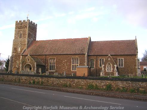
St Mary's Church, Denver. (© NCC)
During the medieval period, Denver was a parish of divided lordship. The medieval moated site of East Hall (NHER
2465) was held by William of Warenne in the Domesday Book, has a possible outer enclosure, but there is no trace of any buildings within the moat, although it remained a manorial site until the 16th century. Close to the site of East Hall manor, on the other side of the village, is the medieval moated site of West Hall (NHER
2464), which also survives as an earthwork.

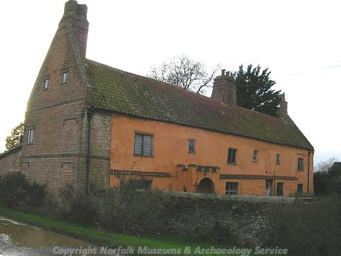
Manor Farm House, a complex timber framed building. (© NCC)
Manor Farmhouse (NHER
12235) is also thought to be a medieval manorial site, and the timber framed house was originally a medieval open hall house, with upper floors inserted in the 16th century. Denver Hall (NHER
2448) itself is a late 15th century manor house, decorated with terracotta panels, which were fashionable in the 16th century. A gatehouse, dated 1570, stands in the grounds of the Hall. St Mary’s Church (NHER
2473) dates mainly from the 14th and 15th centuries, although it may stand on the site of a much earlier building. Several areas of medieval ridge and furrow (NHER
21175,
25378 and
25379) are visible on aerial photographs, and the stepped shape of the parish boundary to the south of the village may represent the former extent of the medieval open fields. Denver had several areas of common land in the medieval period; Whin Common and Sluice Common have survived as place names today, and ‘Cow Lane’ which leads from Whincommon towards the summer pastures on the Fen is a reminder of the importance of livestock husbandry in this area in the medieval period.
During the post medieval periods the commons began to be encroached upon, for example No. 51 Whincommon Road (NHER 39863), an 18th century house, is built on former common land. The drainage and reclamation of the Fens began in earnest in the 17th century, when Vermuyden constructed St John’s Eau or Downham Eau (NHER 2427) in 1642. This channel was destroyed in the 1950s during the construction of a new relief channel. Denver Sluice (NHER 19692) was also built by Vermuyden in the 1650s, but the present structure was built in 1834, and enlarged in the 1920s. The Sluice forms part of the network of defences that prevents the Fens, now fertile arable land, from flooding. During the 18th and 19th centuries, a series of wind pumps (NHER 14506, 14507, 16182, 16183, 16184 and 16333) helped to drain the Fens, before being replaced pumping engines (NHER 16334) in the late 19th century.

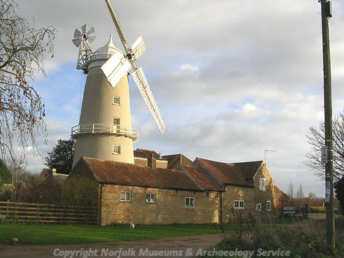
Denver Mill, a 19th century tower mill. (© NCC)
College Farm (NHER
12232) is a 17th century brick house and Crow Hall (NHER
2459) is an early 18th century house, with an unusual cone shaped walled garden, probably built by the horticulturist John Dering. The house also has a Regency ballroom and a brick vaulted cellar. Denver Mill (NHER
12237) is an early 19th century windmill, which was restored in the 1990s and opened to the public.
During World War Two a pillbox and searchlight battery (NHER 32377) was built on Whincommon, and another (NHER 24210) next to Denver Sluice (NHER 19692). In October 1942 a Stirling bomber crashed in the south of the parish, with the loss of all eleven people on board. Parts of the aircraft were recovered by the Fenland Aircraft Preservation Society in the early 1980s.
Sarah Spooner (NLA), 27 October 2005.
Further Reading
Brown, P. (ed.), 1984. Domesday Book: Norfolk (Chichester, Phillimore)
Mills, A.D., 1998. Dictionary of English Place-Names (Oxford, Oxford University Press)
Norfolk Federation of Women’s Institutes, 1990. The Norfolk Village Book (Newbury, Countryside Books)
Rye, J., 1991. A Popular Guide to Norfolk Place-names (Dereham, Larks Press)