This Parish Summary is an overview of the large amount of information held for the parish, and only selected examples of sites and finds in each period are given. It has been beyond the scope of the project to carry out detailed research into the historical background, documents, maps or other sources, but we hope that the Parish Summaries will encourage users to refer to the detailed records, and to consult the bibliographical sources referred to below. Feedback and any corrections are welcomed by email to heritage@norfolk.gov.uk
The parish of Narborough is situated in mid west Norfolk, between Marham to the west and Narford to the east. The origins of its name are somewhat obscure, but may come from the Old English for ‘fortified place at a narrow pass’. People have lived in the parish for a long time, and it was certainly well established by the time of the Norman Conquest, its population, land ownership and productive resources being detailed in the Domesday Book of 1086.
The earliest dateable evidence of human activity comes in the form of Neolithic flint tools, including polished axeheads (NHER 3895, 3896, 3901 and 3902), chipped axeheads (NHER 3897, 3898 and 13833), a laurel leaf point (NHER 29851), arrowheads (NHER 3985 and 29852) and a scraper (NHER 32878). Also from this period is a polished granite axehead (NHER 15709).
It should be made clear at this stage that the parish has been well explored, both by fieldwalking and by metal detecting, and for the purposes of this brief overview only selected examples of finds and monuments are given. Those wishing to dig a little deeper should consult the detailed records.
Several Bronze Age ring ditches (NHER 3906, 11703 and 17012), the traces of flattened round barrows, have been tentatively identified. The Cowell stone (NHER 4557), a large stone in the east of the parish used as a boundary marker, is locally reputed to date from the Bronze Age. Finds from the period include copper alloy palstaves (NHER 3903 and 32933), axeheads (NHER 28742 and 31173) and a spearhead (NHER 32309). A hoard of Middle Bronze Age copper alloy objects (NHER 2664) was found in 1849, comprising two spearheads, a chisel, a flanged axehead and a palstave. Pottery fragments have been recovered from the site of one of the ring ditches (NHER 3906). Flint was still used in the Bronze Age; a flint barbed and tanged arrowhead (NHER 15713) was found on the surface in 1976.

An Iron Age La Tene type II brooch from Narborough. (© NCC)
Evidence of Iron Age activity is unusually plentiful, and the area was obviously of importance at that time. The most important monument to survive is Narborough Camp Iron Age Hillfort (NHER
3975). The earthworks of this Iron Age fort are in Camphill Plantation on the south side of the Nar valley. The fort is strategically placed on a low plateau close to the crossing of the River Nar by the Icknield Way (NHER 1398). The fort consists of a single bank and ditch forming a large oval shape about 150 by 132m. The banks are made of chalk rubble. The west part of the rampart was levelled in the early 19th century. There is a causeway across the ditch to the southwest, probably an original entrance. Very few finds have been recorded from the fort but some pieces of Iron Age, Roman and medieval pot and prehistoric worked and burnt flints have been recovered.
Iron Age finds to date include coins (NHER 28742, 29852 and 31121), pottery fragments (NHER 3976, 31173 and 25776), brooches (NHER 31173, 32309 and 32807), a linch pin (NHER 17641) and a harness fitting (NHER 40968).

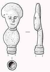
The head of a Roman copper alloy hair pin from Narborough. (© NCC)
West of the line of the old Lynn and Dereham railway (NHER
13600), numerous finds of Roman pottery, coins, building material and other objects since 1944, together with more recent excavation work, indicate the former presence of a Roman temple and villa (NHER
3907). Among the Roman material was a hoard of four silver coins. Finds of other periods, both earlier and later, have also been made. South of Battle’s Farm, metal detecting and fieldwalking has recovered a large number of Roman finds (NHER
18256). These include coins, pieces of pot and a Roman disc brooch. The number of finds suggests this may be part of a larger Roman settlement. Medieval and post medieval finds were also recorded.
Examples of other Roman finds include coins (NHER 3906, 3908, 3909, 3932 and 28742), pottery fragments (NHER 3906, 3932, 3930, and 3933) and brooches (NHER 15148, 25776, 29851, 32309 and 32878).
Bichamditch or The Devil’s Dyke (NHER 3937) is a large linear earthwork traditionally (but perhaps incorrectly) dated to the Early Saxon period. It runs for 11 kilometres between the River Nar at Narborough to the north and a tributary of the River Wissey at Beachamwell. It has a bank up to 2.5m high and ditch on its east side and it runs at right angles to a Roman road (NHER 2796) at Beachamwell, which has led some to suggest that it might have been built by the post-Roman occupants of west Norfolk and the fens to control movement along that road from the east. However, the origins of this and the other linear earthworks of Norfolk remain a matter for debate. An Iron Age date cannot be discounted, with this earthwork associated with the Iron Age fort at Narborough (NHER 3975). An excavation in 2000 on the possible line of the earthwork at Narborough found no evidence of it.
Saxon finds consist of pottery fragments (NHER 3906, 3932, 28324, and 32794), brooches (NHER 28324, 31173, 32309 and 32878), coins (NHER 28742 and 29852), pins (NHER 32309) and a stirrup mount (NHER 33306).
The medieval period has left the parish with its oldest surviving building, All Saints’ Church (NHER 3942). Attractively set in the centre of the village, this church consists of an aisled nave, chancel, south porch, southwest tower, west vestry and north organ chamber. The oldest part is the Norman north door, the rest being largely of about 1300, extended in the later 14th century and remodelled in the 15th century. After being later reduced in size, the church was heavily restored in 1865 and 1906. Inside are important monuments, mainly to the Spelman family. The churchyard has a very important group of World War One Royal Flying Corps graves and an 18th century summerhouse from the former rectory garden.

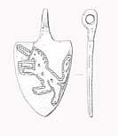
A medieval horse harness pendant from Narborough. (© NCC)
Other medieval buildings have not survived, but have left a footprint of their surrounding moat, an example being NHER
41952 northeast of All Saints’ church. A narrow hollow (NHER
41953) way leads from the moated site towards the church. East of the main road is an area of earthworks (NHER
32794), including possible medieval house platforms, enclosures and roadways. Iron Age, Saxon and medieval pottery fragments found on the site indicate a long period of occupation.
Medieval objects recovered include coins (NHER 3908, 3935, 17628, 28324 and 27842), pottery fragments (NHER 3906, 3932, 3935 and 32794), buckles (NHER 32878 and 40968), a brooch (NHER 32168), an iron key (NHER 15710) and a gold finger ring (NHER 35986).
Of the post medieval buildings to survive, Narborough Hall (NHER 3938) is probably the oldest. This imposing country house is set in seventy nine acres of park and woodland, containing two lakes and a stretch of the river Nar. Built on the site of earlier houses (there are traces of a medieval surrounding moat, later ornamentalised), the Spelman family started the current hall in the late 16th century, incorporating quantities of reused medieval stone, probably from a monastery or priory. After various minor alterations, the hall was extended in the 18th century by the addition of wings at each end, and later to the rear, giving the building an L shaped plan.
A landmark for motorists on the former main Swaffham to King's Lynn road, Narborough Mill (NHER 3940) is an imposing three storey brick former watermill dating to the late 18th century. 19th century additions were demolished when the building was extended and repaired in the late 20th century. Part of the Narborough trout fishing estate until the 1990s, the mill is now thought to have been converted to residential use.
Church Farm (NHER 16420) was originally a small clunch and brick cottage, extended into a large farmhouse in about 1800, when farm buildings and a barn were added. The grand house was built in about 1860 when the farm became independent from the hall (NHER 3938). Like the hall, both the earlier buildings contain reused medieval stone.
On the river is a 19th century watermill and maltings (NHER 3939). One of the buildings crosses the river by a large archway that seems to contain a waterwheel. Mainly derelict by 1980, it was being considered for redevelopment, but was seriously damaged by a fire in 1992. Its current status is not known.
The site of a bone mill (NHER 15706), built in about 1830. The mill ground up whale bones from a blubber house in King's Lynn. The large iron waterwheel, and reportedly some of the millstones remain.
A section of the Lynn and Dereham railway (NHER 13600) ran through the parish. This railway line operated between King's Lynn and Dereham. There were stations at King's Lynn, Middleton (called Middleton Towers), East Winch, Narborough and Pentney (one station served both villages), Swaffham, Sporle, Dunham, Fransham, Wendling, West Bilney and Dereham. The railway opened to Narborough in 1846, Sporle in 1847 and finally reached Dereham in 1848. It closed in 1968 except for sand trains to Middleton quarries. Most of the line has been removed but many of the stations remain now converted into houses. There are several good examples of under and over bridges.
In the south of the parish is the site of a World War One airfield (NHER 13621). A landing ground, airfield and training depot from 1915. It was closed in 1919 but the hangar remained until it was blown down in 1977. The small building left on the site is now used as a YMCA.
Southwest of this, part of RAF Marham (NHER 4510) encroaches into Narborough. This was an airfield first used by the Royal Flying Corps during World War One and then the Royal Air Force during World War Two. It continued in use during the Cold War and is still active. The airfield had three Picket Hamilton forts during World War Two. The Cold War Hardened Nuclear Shelters built here in the 1980s are considered to be of national importance.
In the north of the parish is a World War Two concrete anti tank mortar base (NHER 28353), part of the network of anti invasion structures of the time.
Piet Aldridge (NLA), 1 November 2006.
Further Reading
Brown, P., 1984. Domesday Book; Norfolk (Chichester, Phillimore & Co)
Rye, J., 1991. A Popular guide to Norfolk Place Names (Dereham, The Larks Press)