This Parish Summary is an overview of the large amount of information held for the parish, and only selected examples of sites and finds in each period are given. It has been beyond the scope of the project to carry out detailed research into the historical background, documents, maps or other sources, but we hope that the Parish Summaries will encourage users to refer to the detailed records, and to consult the bibliographical sources referred to below. Feedback and any corrections are welcomed by email to heritage@norfolk.gov.uk
Besthorpe is a small parish just to the east of Attleborough. Lying in the heart of Breckland the parish includes Besthorpe and the smaller hamlet of Black Carr. The origins of the villages are unknown, but the name Besthorpe has been translated as ‘outlying farmstead or hamlet of a man called Bosi’ (outlying from larger Attleborough?) or ‘where bent grass grows’. The settlement has now been effectively joined to Attleborough as settlement has grown along the main road. Black Carr could be translated as ‘the black marshy woodland area’. The isolated settlement here has grown up around a small farmstead. The archaeological remains from the parish are quite extensive.

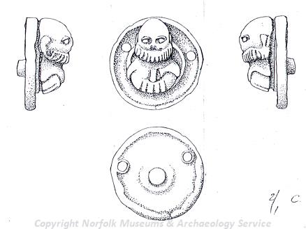
Roman mount probably portraying Silenus from Besthorpe. (©NCC)
There is evidence for prehistoric activity in the area from the many burnt and worked flints recovered during fieldwalking. The earliest finds date to the Mesolithic period and include a flint axehead (NHER
30701) and a macehead (NHER
14540). There are also several surface finds dating to the Neolithic period – an arrowhead (NHER
19399) and another axehead (NHER
28988). No prehistoric sites have been identified. The earliest evidence for settlement in the parish dates to the Late Iron Age when several Iron Age coins and prehistoric pottery might demonstrate a Late Iron Age date for the establishment of a settlement near the church (NHER
29171). The most prolific finds from this site are, however Roman. These include a mount that probably portrays the Roman god Silenus. A thriving settlement must have been here – over 300 Roman coins and numerous brooches have been metal detected from the area.
A second Roman settlement (NHER 29740) has been fieldwalked at Black Carr. Roman pottery including high value Samian has been identified here. This site may have extended to the northwest where other Roman finds have been made (NHER 29016). Roman coins and brooches have also been found in other places across the parish.
In contrast to the richness of Roman finds in the area there is only one recorded Saxon object from the parish. A set of Early Saxon loomweights (NHER 9125) was found southeast of the railway. There is extensive evidence for medieval activity, however. Although the Domesday book only describes Besthorpe as occupied by one freeman, one villager and seven smallholders, only a short period later there is evidence for two medieval moated sites (NHER 1056 and 9131). Besthorpe Hall (NHER 9132) was built by the Drury family in 1590, and they have a large tomb within the 14th century church (NHER 9137). There is a large earthwork that runs along the parish boundary known as Bunn’s Bank (NHER 9127 and 9206). This may be a medieval park enclosure, but probably dates earlier, perhaps to the Saxon period, and was then reused as the park boundary for Old Buckenham Hall (NHER 11810). Two medieval seals (NHER 13936 and 32870) have been recovered from the parish – we can identify the owner of one of them as John of Uckham from the inscription.
There is little evidence of post medieval occupation of the parish – it may be that evidence for this all lies beneath the modern villages. Certainly several post medieval buildings still remain in Besthorpe and Black Carr and there are reports of an earlier medieval building over the Old Rectory (NHER 41084) with an inscription over a fireplace reading ‘All you that sitt by thys fire warming, Pray for the sowle of Sir Iohn Downyng’. A post medieval coin hoard (NHER 16236) has also been recovered from the parish, close to the earlier moat site (NHER 1056), containing silver coins of Mary I and Elizabeth I.
Besthorpe was once the home of two windmills (NHER 15964), one a tower mill and the other a postmill, but both of these have now been demolished. Excavations under the miller’s house found that parts of a goose had been buried beneath the foundation to bring good luck. More modern remains include that of a rare type of pillbox (NHER 32713) that was built against Compass House and is still standing and also two mysterious buildings and a linear feature (NHER 35956) that runs between them (a secret tunnel?) that have shown up on aerial photographs and may have been used by the Americans in World War Two.
Megan Dennis (NLA), 29th July 2005.
Further Reading
Brown, P. (ed.), 1984. Domesday Book, 33 Norfolk, Part I and Part II (Chichester: Phillimore)
Mills, A.D., 1998. Dictionary of English Place Names (Oxford: Oxford University Press)
Neville, J., 2004. ‘Norfolk Mills – Besthorpe tower windmill’. Available:
http://www.norfolkmills.co.uk/Windmills/besthorpe-towermill.html. Accessed 30 January 2006.
Unknown, unknown. ‘William Drury of Besthorpe (Knight)’. Available:
http://www.tudorplace.com.ar/Bios/WilliamDruryof%20Besthorpe(Sir)1.htm. Accessed 30 January 2006.