This Parish Summary is an overview of the large amount of information held for the parish, and only selected examples of sites and finds in each period are given. It has been beyond the scope of the project to carry out detailed research into the historical background, documents, maps or other sources, but we hope that the Parish Summaries will encourage users to refer to the detailed records, and to consult the bibliographical sources referred to below. Feedback and any corrections are welcomed by email to heritage@norfolk.gov.uk
Upper Sheringham is a small parish situated on the north Norfolk coast. It is south of Sheringham itself and north of West Beckham. The name ‘Sheringham’ is thought to derive from the Old English for homestead of Scira’s people.
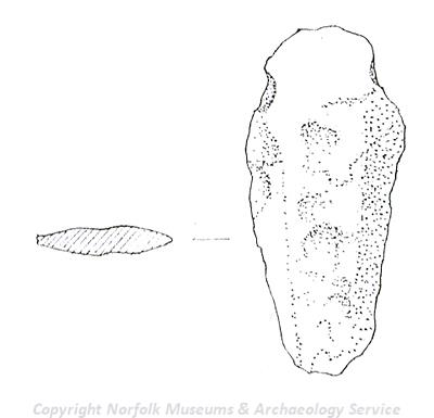
Bronze Age dagger or spearhead fragment from Upper Sheringham. (© NCC)
The earliest dated finds from the parish are Neolithic axeheads (NHER
6288,
6289 and
6291). A Bronze Age dagger or spearhead fragment (NHER
30018) has also been recovered. The earliest dated monuments are Bronze Age barrows. Howe’s Hill (NHER
6292) is a complex example of this type of monument that probably incorporates an earlier oval barrow with a later round barrow built on top of it. A Bronze Age pottery urn was found here in the 19th century. Cropmarks of other barrows (NHER
34183,
34182 and
27997) have been identified on aerial photographs as part of the Norfolk National Mapping Programme.
This program has also identified a possible Iron Age or Roman enclosure (NHER 27978). Iron Age coins (NHER 6269, 6270 and 6293) have been found in several places along the coast in the parish including examples made in Gaul (NHER 6265). It is possible that these originally came from a hoard in the cliff that has since been dispersed.
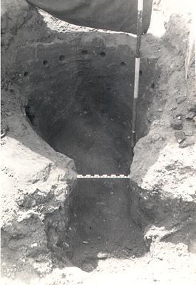
Excavation of a Roman kiln in Upper Sheringham in 1953. (© NCC)
The chamber and part of a stoke hole of a Roman pottery kiln were dug out when a fence in the parish was constructed in 1956 and the site was subsequently excavated (NHER
6295). The site was completely excavated in 1956. The kiln was probably in use between AD 100 and 140. The floor was formed of a series of radiating clay bars. Many pieces of over fired clay were found. These show the kiln was used to fire greyware storage jars, platters and beakers. Roman coins (NHER
6294,
6296 and
15602), pieces of pot (NHER
15602) and a brooch (NHER
29419) have also been recorded.
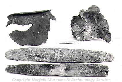
Kiln furniture from the Roman kiln excavated in Upper Sheringham in 1953. (© NCC)
Metal detecting has recovered pieces of an Early Saxon brooch (NHER
29419), a Middle Saxon strap end (NHER
30018) and a Late Saxon box mount (NHER
30018) and strap fitting (NHER
25894). The area may have been used for the extraction of iron ore – several possible ironworking pits have been recorded in the area (NHER
38248,
38243 and
38244).
The Domesday Book is a census of the population and productive resources of the country. It was created in 1086. The Domesday entry for Sheringham covers both Sheringham and Upper Sheringham parishes and mentions a church, villagers, smallholders, slaves, ploughs, woodland, pigs, meadow, a horse, cattle, pigs and goats. In 1086 land at Sheringham was held by William of Ecouis.
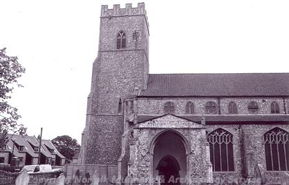
The tower of All Saints' Church, Upper Sheringham. (© NCC)
All Saints’ Church (NHER
6305), was built in the late 13th or early 14th century. The side windows date to the 15th century when the porch was probably also constructed. Abbot Upcher's mausoleum was added to the north of the church in 1820. Inside is an important 14th or 15th century roof screen with a loft and carved pews. When the boiler house was removed a number of 13th century stone coffin lids were found. The medieval cross base in the church comes from a different site in the parish (NHER
21293). The earthworks of a medieval hollow way (NHER
24267) have also been identified. These are a very well-preserved example of this type of medieval sunken road. It consists of a bank and a ditch about 2m deep that broadly follows the parish boundary until it crosses into Sheringham parish, where it becomes a modern road. The site of a possible medieval windmill (NHER
34182) has also been identified on aerial photographs.
A number of medieval objects have been recovered from the parish. These include an ampulla and seal matrix found on the same site by a metal detectorist (NHER 32214), a vessel leg (NHER 32210), a buckle (NHER 32204) and a harness pendant (NHER 32209). A more unusual lead bird feeder trough (NHER 32212) has also been recorded.
Apart from the church the most well-known building in the parish is Sheringham Hall (NHER 6297). The hall was designed in 1812 by Humphrey Repton for Abbot Upcher and was completed by 1839. It stands on the site of an earlier Jacobean style hall. The present two storey gault brick building has a Tuscan porch to the west and a colonnade to the south. The surrounding park (NHER 22881) was Humphry Repton's last commission before his death in 1818. Repton produced a Red Book, containing his recommendations for the layout of the park, in 1812, and work on the park was almost complete by 1817. The entrance drive was carefully planned so that visitors to the park would not see the dramatic view of the house against the backdrop of the sea until the last moment. The temple, which stands on a high point in the park overlooking the house, was built in 1975 to one of Repton's designs that was never carried out. The impressive rhodedendron collection was started in the 1850s in the woods at the edge of the park. Repton himself considered Sheringham to be his favourite commission, and the park is now regarded by many as his finest work. The park is now in the care of the National Trust, and is open to the public.
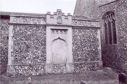
Bishop Upcher's mausoleum, All Saints' Church, Upper Sheringham. (© NCC)
Abbott Upcher also built The Conduit (NHER
36527) in 1814 over the end of a water conduit or a spring. The flint and gault brick structure is perched above a circular cistern. Water flows into the cistern through a spout at the rear and out via two spouts at the corners.
The remains of the old Lifeboat House (NHER 6255) on the Old Hythe are visible on aerial photographs from the 1940s and have subsequently been exposed in the cliff by the sea. During World War Two the Lifeboat House remains were incorporated into the defences and training activities (NHER 38622).
The 19th century Midland and Great Northern Joint Railway north to south line (NHER 13584) passes through the parish. The stretch between Sheringham and Weybourne reopened as the North Norfolk Railway in the 1970s. 19th century stations, signal boxes, bridges and embankments survive in a number of locations along the line.
Being a coastal parish several training and defensive structures were built here during World Wars One and Two. The possible earthwork remains of a World War One firing range (NHER 38617) are visible along the coast at Upper Sheringham on aerial photographs. This site also gets incorporated into later World War Two defences and training activities. Other World War Two features include pillboxes (NHER 18110, 31023 and 32506), an anti-tank ditch (NHER 32505), spigot mortar emplacements (NHER 32527 and 32507) and practice trenches (NHER 38238 and 38239).
The most modern archaeological sites recorded are a series of coastal defences (NHER 38614) and a cast iron red telephone box (NHER 47501) designed by Sir Giles Gilbert Scott in 1935.
M. Dennis (NLA), 26 July 2007.
Further Reading
Ashwin, T. & Davison, A., 2005. An Historical Atlas of Norfolk (Chichester, Phillimore)
Barringer, C., 1989. Faden’s Map of Norfolk (Dereham, Larks Press)
Brown, P. (ed.), 1984. Domesday Book: Norfolk (Chichester, Phillimore)
Cox, P., no date. 'A brief history of Sheringham'. Available:
http://www.northnorfolk.org/sheringham/downloads/ABriefHistorOfSheringham.doc. Accessed: 23 December 2005.
Erroll, A. C., 1907. A history of the Parishes of Sheringham and Beeston Regis in the County of Norfolk (Sheringham, A. Campbell Eroll)
Mills, A. D., 1998. Dictionary of English Place-Names (Oxford, Oxford University Press)
Poppyland Press, unknown. 'Sheringham, Norfolk'. Available:
http://www.poppyland.co.uk/norfolk/sheringham.htm. Accessed: 23 December 2005.
Rye, J., 1991. A Popular Guide to Norfolk Place-names (Dereham, Larks Press)