This Parish Summary is very much an overview of the information held for the parish, and only selected examples of sites and finds in each period are given. It has been beyond the scope of the project to carry out detailed research into the historical background, documents, maps or other sources, but we hope that the Parish Summaries will encourage users to refer to the detailed records, and to consult the bibliographical sources referred to below. Feedback and any corrections are welcomed by email to heritage@norfolk.gov.uk
The small Breckland parish of Yaxham is situated in mid Norfolk, to the south of the much larger parish of East Dereham. Its name comes from the Old English for either ‘cuckoo’s meadow’, or, less attractively, ‘Geac’s homestead’. The parish has a long history, and was certainly well established by the time of the Norman Conquest, its population, land ownership and productive resources being extensively detailed in the Domesday Book of 1086.
The earliest dateable evidence of human activity is a little ambiguous. A prehistoric chipped flint axe (NHER 19153) was found on the surface of a field in 1983. At first it looked to be Palaeolithic in date, but it could equally well be an unusual or re-worked Neolithic example. More closely dateable early evidence comes in the form of two Mesolthic flint tranchet axeheads (NHER 23716 and 24945), and a Neolithic polished flint axehead (NHER 24946).
No Bronze Age or Iron Age finds or features have as yet been identified, and the only Roman object found to date is part of a puddingstone quern (NHER 3070), although this could be medieval in date. Saxon finds currently consist of two pottery fragments, one Middle Saxon and one Late Saxon (NHER 19812) and a very rare Middle Saxon silver penny of Coenwulf of Mercia (796 to 821) (NHER 3067), which was found on the surface of a ploughed field in 1961.
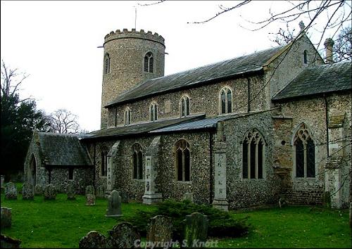
The medieval period has left the parish with its oldest surviving building, St Peter’s Church (NHER 1085). Approached along the rather alarmingly named Cut Throat Lane, this trim and well maintained church in its circle of trees consists of a round west tower, the base of which has a banding of carstone and is probably Late Saxon, a nave with a south aisle and clerestorey, a south porch and a chancel. The upper part of the tower is 14th century and the crenellated parapet post medieval. The rest of the church is 14th and 15th century work, subjected to a Victorian restoration that included the rather fussy chancel windows. Inside is a Saxon tower arch, which has a smaller arch high above it, either providing access to the roofspace for maintenance and lighting, or to the ringing chamber other than by way of the tower ground floor when other liturgical activities were in progress. The body of the church is lit by an excellent series of 19th century stained glass windows, the east window being the best example. In the south aisle are some splendidly carved 19th century bench ends, including on the front pew a pelican. The 15th century carved octagonal font is quite stunning and in a very good state of preservation. Outside again, just to the southwest of the porch is a good 18th century limestone table tomb.

St Peter's Church, Yaxham. Photograph from www.norfolkchurches.co.uk. (© S. Knott.)
Other medieval buildings have not survived, but their former presence can be ascertained from finds on the ground and from interpretation of aerial photographs. In an area northeast of Frogs Hall Farm, two pieces of medieval pottery and oyster shells were found in 1962 on a slight rise in a field bounded by ditches, suggesting this was the site of a medieval moated farmstead. The site is difficult to make out from the ground, but aerial photographs show the cropmarks of a rectangular moat or ditched enclosure, within which are two rectangular marks likely to be building foundations (NHER
3068). South of Watering Farm, aerial photography shows the cropmarks of a square ditched enclosure which has the appearance of a small medieval moat (NHER
36393).
Medieval finds include pottery fragments (NHER 3069, 18092 and 23716) and a coin (NHER 16551).
Of the post medieval buildings to survive, probably the oldest is Willow Farm (NHER 19811) on Norwich Road. This house consists of two ranges. To the rear is a 16th century timber framed house with clay lump infill, much altered in the later 16th and 17th centuries, including the insertion of floors and chimneys into the original open hall. The front range is early 19th century. The house was restored in the 1980s, when pieces of medieval and post medieval pottery were found in the garden.
Hollands Hall (NHER 15809) on Brakefield Green is a late 16th century and later house of diapered brickwork, two storeys high with attics and stepped end gables. It has a central porch with stepped gables, polygonal angle-shafts and a brick doorway with a four-centred arch. The first floor has 18th century windows and those to the right of the porch are of the same date. However, one 16th century mullioned window remains to the left on the first floor.
Boronia Cottage (NHER 13778) on Norwich Road is a two storey timber framed cottage dating from 1611 with later alterations.
Yaxham Barn (NHER 43967), formerly Glebe Farm Barn, east of Cut Throat Lane, is a timber framed three stead threshing barn on a brick plinth, dating to around 1700. The original infill, probably of clay and straw, was replaced in brick in the 19th century when a pentise was added along the north side. Further alterations took place later. The barn has now been converted to a house.
Ashtree Farm (NHER 45501), formerly Robjoy, on Paper Street, is an 18th century two storey brick cottage with a pantile roof and later additions and alterations.
Built as the rectory by Robert Lagar in 1822 for the Reverend John Johnson, Yaxham House (NHER 13779) is a two storey colourwashed brick building in the style of an Italianate villa, with slate roofs. The symmetrical entrance façade has three window bays, the outer ones projecting slightly under pediments, and a large central entrance porch on pairs of Greek Doric columns. Inside, the chimneypiece was painted by William Blake from a painting by William Cowper (Johnson's cousin), though the remaining fragments of the painting are thought to have been moved.
Other post medieval structures have not survived. But are referred to in old documents and maps. Documentary sources point to there being a gibbet (NHER 12293) on Bradley Moor where a criminal named Cliffe was executed in 1785. Apparently his bones were ploughed up some years later and his skull taken into private possession.
Another post medieval feature has been identified north of Willow Farm. Fieldwalking from 1983 to 1984 recovered post medieval pottery fragments and kiln furniture, indicating that the area was probably a 16th to 17th century pottery production site (NHER 19812).
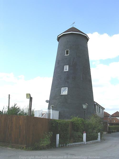
East of the village is the site of a post mill of 1810 and a nearby tower mill of about 1860 (NHER 13777). The tower mill was last turned by wind in 1922, after which it was steam powered until the modern mill buildings were constructed on the site. Its brick tower remains among the new buildings and is used for storage.

The 19th century tower mill. (© NCC)
Running from north to south through the western side of the parish is the route of the Wymondham to Wells Branch Line (Great Eastern Railway) (NHER
13588), Today the Mid Norfolk Railway operates steam and diesel trains on the line between Dereham and Wymondham Abbey. Stations or halts survive at Kimberley, Hardingham and Thuxton and Yaxham, Dereham, North Elmham, County School, and Wells. The Dereham to Wells line was opened by the Norfolk Railway in 1849, and the Dereham to Wymondham line for freight in 1846 and passengers in 1847. The Dereham to Wells line closed in 1964 and the Dereham to Wymondham closed in 1969.
P. Aldridge (NLA), 19 September 2007.
Further reading
Rye, J., 1991. A Popular Guide to Norfolk Place Names (Dereham, The Larks Press)
Brown, P. (Ed.) Domesday Book; Norfolk (Chichester, Phillimore & Co)
Knott, S., 2006. ‘The Norfolk Churches Website’. Available http://www.norfolkchurches.co.uk/yaxham/yaxham.htm
Accessed 29 August 2007
Pevsner, N. & Wilson, B., 1997. The Buildings of England: Norfolk 2: North-West and south (London, Penguin Books)