This Parish Summary is an overview of the large amount of information held for the parish, and only selected examples of sites and finds in each period are given. It has been beyond the scope of the project to carry out detailed research into the historical background, documents, maps or other sources, but we hope that the Parish Summaries will encourage users to refer to the detailed records, and to consult the bibliographical sources referred to below. Feedback and any corrections are welcomed by email to heritage@norfolk.gov.uk
Mundford is a small parish in Breckland, close to the town of Thetford. The northern parish boundary follows the course of the River Wissey and the small village of Mundford sits on the banks of the river. The huge plantations that were planted during the first half of the 20th century in the area around Thetford now dominate the majority of the landscape of the parish.
The earliest archaeological artefacts from the parish are Palaeolithic flint handaxes and a Levallois flake (NHER 5094). A bowl-shaped pit, possibly dating to the prehistoric period, was excavated in 1961. The pit contained a layer of charcoal and burnt flints. Prehistoric flints (NHER 4989) have been found scattered throughout the parish, including Mesolithic or Neolithic flint scrapers, fabricators and other implements (NHER 5095), Neolithic flints including several axeheads (NHER 5096, 14330, 5098, 5099, 5101 to 5106, 14829), Neolithic arrowheads (NHER 14827, 14828, 17041, 39496, 39497) and a flint knife (NHER 5097). A number of Beaker barbed and tanged arrowheads (NHER 5097, 5098, 5100, 14826, 14828, 39488, 39498), a Bronze Age socketed axehead (NHER 5107), a Bronze Age spearhead tip and socketed knife (NHER 14330), and a dirk or dagger (NHER 28202). A human skeleton (NHER 4985, 21346) buried with a copper alloy clip was discovered in 1925. The skeleton has been dated to either the Bronze Age or the Early Saxon period.
There is some evidence of Iron Age occupation in the parish, and coins (NHER 14330) and an Iron Age or Roman brooch (NHER 28202) have been found during metal detecting.

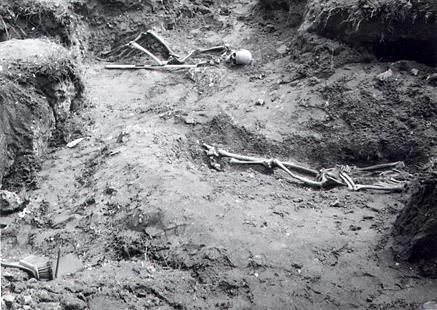
The excavation of a Roman inhumation cemetery in the 1960s. (© NCC)
The site of a Roman inhumation cemetery (NHER
4981) was discovered in the north of the parish in 1963. At least seven inhumations have been recovered from the site, including two skeletons that had been decapitated!
Other Roman finds from the parish include fragments of Roman pottery (NHER 4983, 4984, 11424, 19577, 20416, 23416, 23875), tiles (NHER 4989, 14330), coins (NHER 5110, 11425, 22233, 28196, 28197, 28202 to 28204), brooches (NHER 14330, 22233) and a quern (NHER 5111).
The site of an Early Saxon inhumation cemetery (NHER 5112) was found in the 1950s, and several inhumations, as well as Early Saxon knives and spearheads were recovered. The skeleton of a young man (NHER 4986) from the Early Saxon period was discovered in 1967. He had been buried with a brooch, beads and wrist clasps. Metal detecting has also recovered Early Saxon brooches (NHER 11413, 11799, 14330, 35073, 35795), a pin (NHER 28202), and a pendant in the shape of an axe (NHER 40789). Fragments of Middle Saxon pottery (NHER 20416) and a sceat (NHER 28202), a Late Saxon socketed iron axe (NHER 5113) and pieces of pottery (NHER 5114) have been found.

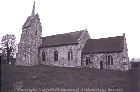
St Leonards Church in Mundford. (© NCC)
St Leonard’s Church (NHER
5155) has an aisleless nave, a north porch with chequered brick and knapped flint, and a mid 19th century southwest tower. The interior of the church has a 14th century chancel arch, a 14th century font with mutilated carvings and a late medieval chancel screen with early 20th century tracery and an organ loft. The earthworks of a rectangular moated enclosure (NHER
31916) are visible on the ground and on aerial photographs near Lynford Road Farm. The moat may have been the site of a parsonage during the medieval and post medieval periods. Fragments of post medieval brick and pottery have been found within the moat. Medieval finds include a silver bracelet (NHER
5117) and a 13th century gilded ring brooch with two animal heads (NHER
23696).
West Hall (NHER 11416) is a 16th century timber framed house with 17th and 18th century additions, possibly on the site of a medieval manor house. The building incorporates reused medieval timber and stonework. Interior features include a fine 17th century staircase and very elaborate late medieval carved bridging joists with deeply undercut leaf patterns. Fir Cottage, The Cottage and The Little House (NHER 44643) are a row of 17th century timber framed cottages with thatched roofs. Rosemary Cottage (NHER 44645) is an 18th century timber framed cottage with a thatched roof, although there is evidence of an earlier structure within the house, which is built on a lobby-entrance plan. The Crown Hotel (NHER 44641) is a 17th century and later house and pub, built in brick and flint. The southern end of the main block is probably the original building, and the house has 19th century sash windows and a moulded brick string course. 33 St Leonard's Street (NHER 44644) is an early 18th century house with an early 19th century façade in knapped flint with brick dressings. The side façade has a chequered pattern of knapped flint and clunch, and the house has an open porch with plain columns and a later rear wing. Brockholm (NHER 44642) is an early 19th century flint and brick house with sash windows and a raised veranda. The roof is supported by fluted columns, and there is a central flight of steps from ground level to the veranda. Lower Mill (NHER 5004) was a tower mill built in the 1840s. The mill was in use until the 1890s and the building was demolished in the 1970s. a post medieval smock mill (NHER 16210) is marked on Bryant’s map of 1826 and on an Ordnance Survey map of 1836 on land off Thetford Road.
A Lancaster bomber crashed to the south of the village (NHER 33637) in March 1945, with the loss of six of the seven crew. A large earthwork crater marks the site of the crash, and a permanent memorial has been erected.
Sarah Spooner (NLA), 31 July 2006.
Further Reading
Brown, P. (ed.), 1984. Domesday Book: Norfolk (Chichester, Phillimore)
Mills, A. D., 1998. Dictionary of English Place-Names (Oxford, Oxford University Press)
Rye, J., 1991. A Popular Guide to Norfolk Place-names (Dereham, Larks Press)