This Parish Summary is an overview of the large amount of information held for the parish, and only selected examples of sites and finds in each period are given. It has been beyond the scope of the project to carry out detailed research into the historical background, documents, maps or other sources, but we hope that the Parish Summaries will encourage users to refer to the detailed records, and to consult the bibliographical sources referred to below. Feedback and any corrections are welcomed by email to heritage@norfolk.gov.uk
Stokesby with Herringby is a small parish in the east of the county. The River Bure is the southern parish boundary, and the northern and western boundaries follow the course of the Muck Fleet. The small village of Stokesby is in the south, and a number of scattered farms are on a small spur of land overlooking drained marshland.
A Palaeolithic flint flake (NHER 8591) was found in 1968, and other prehistoric flints (NHER 41010) have been collected during metal detecting.
The site of a small Roman settlement (NHER 41010) has been revealed by metal detecting. An Iron Age or Roman terret, Roman pottery, coins, brooches and other metal finds have been recovered from the site. A Roman brooch (NHER 28808), Roman pottery (NHER 41137) and a Roman furniture fitting (NHER 42566) have been found in the area around the settlement. The cropmarks of a field system and trackway (NHER 21840) are visible on aerial photographs. The cropmarks may date to the Iron Age to Roman or medieval periods. A Roman salt works (NHER 8646) was recorded in the parish in 1926.
Stokesby comes from a mixture of Old English and Old Scandinavian meaning ‘village with an outlying farmstead or pasture’. Herringby comes from the Old Scandinavian meaning ‘village or settlement of the people of Herringr’. Middle and Late Saxon pottery (NHER 41010), Late Saxon strap ends (NHER 41010, 37430) and a strip from a Late Saxon or early medieval casket (NHER 37430) have been found by metal detecting. Both Stokesby and Herringby are mentioned in the Domesday Book. Stokesby is recorded as a large and valuable manor held by a free man named Edwin, with a church and various outlying lands. Herringby is recorded as a smaller holding held by Reinbald the Goldsmith.
Herringby was gradually deserted during the medieval period. The church of St Ethelbert (NHER 8592) is shown on a 16th century estate map but there are no longer any standing remains. Fragments of medieval masonry have been incorporated into the garden walls of Herringby Hall (NHER 8592), a 19th century house that stands on the probable site of the medieval village.
The earthworks of a medieval to post medieval enclosure (NHER 42175) and various medieval to post medieval drainage ditches and channels (NHER 42404, 42405, 42427) have been recorded from aerial photographs. Medieval and post medieval pottery and metal finds have been found throughout the parish during fieldwalking and metal detecting.
St Andrew’s Church (NHER 8623) in Stokesby dates mainly from the 13th and 14th centuries with later alterations. The church contains a 15th century brass to Sir Edward Clere and his wife.

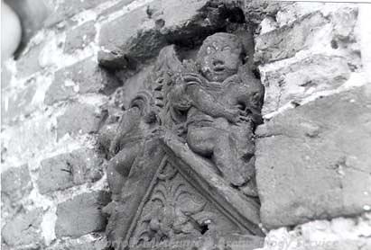
A terracotta plaque at Stokesby Hall. (© NCC)
Stokesby Hall (NHER
8615) is on the site of a medieval manor house built by the Clere family. The earliest part of the Hall is a 16th century porch tower with decorative terracotta panels, and the rest of the Hall dates to the 17th and 18th centuries. Manor Farm (NHER
8613) is an early 17th century farmhouse, with decorative brickwork and a walled garden.
Bure Reach (NHER 8624) is an 18th century house with reused medieval stone doorways. The Thatched House (NHER 42906) is a mid 18th century house with a thatched roof. Martinstaithe and Staithe House (NHER 42905) is an 18th century house now divided into two.
Commission Mill (NHER 8610) is an early 19th century drainage mill, and a mill is marked on the same site on Faden’s map of 1797, and the nearby miller’s cottage (NHER 42904) dates from the late 18th century. Trett’s Mill (NHER 8614) is an early 19th century tower mill that was in use until 1916.
Two possible World War Two bomb craters (NHER 42176) are visible on contemporary aerial photographs.
Sarah Spooner (NLA), 15 February 2006.
Further Reading
Brown, P. (ed.), 1984. Domesday Book: Norfolk (Chichester, Phillimore)
Mills, A. D., 1998. Dictionary of English Place-Names (Oxford, Oxford University Press)
Rye, J., 1991. A Popular Guide to Norfolk Place-names (Dereham, Larks Press)