This Parish Summary is an overview of the large amount of information held for the parish, and only selected examples of sites and finds in each period are given. It has been beyond the scope of the project to carry out detailed research into the historical background, documents, maps or other sources, but we hope that the Parish Summaries will encourage users to refer to the detailed records, and to consult the bibliographical sources referred to below. Feedback and any corrections are welcomed by email to heritage@norfolk.gov.uk
Coltishall, from the Old English meaning ‘a nook of land belonging to Cohede’, is situated on the Broads, and is popular with tourists for its picturesque buildings and river. Settlement in the parish is focused on the village of Coltishall, and the hamlet of Great Hautbois.
A number of prehistoric flint implements have been found scattered throughout the parish, many of which date to the Neolithic period, including axeheads (NHER 7672, 22613, 23254), a knife (NHER 24065), and a mace (NHER 8045). The sites of thirteen ring ditches (NHER 36338, 31743, 36339, 36346), probably the remains of Bronze Age barrows, are visible on aerial photographs, overlooking the River Bure. One ring ditch is close to the site of several circular enclosures, one of which contains a hut circle dating to the Bronze Age or the Iron Age (NHER 36129). There is not such definite evidence for settlement during the Roman period, although many Roman coins (NHER 8046, 21287, 34866), brooches (NHER 8049, 8050) and fragments of pottery (NHER 35717, 8048), have been found in the parish, suggesting that settlement continued to develop here throughout the Roman period.

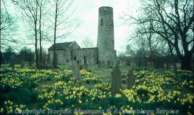
The ruins of St Theobald's Church, Great Hautbois. (© NCC)
An Early Saxon brooch (NHER
21955) is the sole artefact from the Saxon period that has been found in Coltishall. In Domesday Book however, there was a relatively substantial settlement at Coltishall, including a church, and St John the Baptist’s Church (NHER
4767) in Coltishall dates to the Late Saxon period. The nearby hamlet of Great Hautbois, from the Old English meaning ‘a meadow with tussocks’, is also mentioned in Domesday Book, which lists the eight acres of meadow, from which the hamlet draws its name. St Theobald’s Church (NHER
7677) in Great Hautbois also dates to the Late Saxon period, and the walls contain Roman bricks.
During the medieval period a castle (NHER 7679) was constructed in Great Hautbois in 1312 by Sir Robert Bainard, and the moat, bailey and foundations of buildings are still visible on the ground. It was during the post medieval period that Coltishall grew substantially into a small town, with a wealth of 17th and 18th century buildings in the village, such as the School House (NHER 4768), the Limes (NHER 4771), Lower House (NHER 4774) and the Old Hall (NHER 25824), all of which date to the 17th century. Coltishall prospered in the 17th and 18th centuries and a former malting complex dating from the 18th century (NHER 19209), and several lime kilns (NHER 16678, 16680) survive in the village. The Bure Navigation Canal (NHER 29856), constructed in the 1770s between Aylsham and Coltishall, and the Lock Cut (NHER 28753) brought more trade into the parish, and stimulated the boat building industry.
The modern landscape of Coltishall is dominated by the nearby RAF base (NHER 7697), which was used as a fighter base during World War Two and the Cold War.
Sarah Spooner (NLA), 15 September 2005.
Further Reading
Brown, P. (ed.), 1984. Domesday Book: Norfolk (Chichester, Phillimore)
Mills, A.D., 1998. Dictionary of English Place-Names (Oxford, Oxford University Press)
Rye, J., 1991. A Popular Guide to Norfolk Place-names (Dereham, Larks Press)