This Parish Summary is an overview of the large amount of information held for the parish, and only selected examples of sites and finds in each period are given. It has been beyond the scope of the project to carry out detailed research into the historical background, documents, maps or other sources, but we hope that the Parish Summaries will encourage users to refer to the detailed records, and to consult the bibliographical sources referred to below. Feedback and any corrections are welcomed by email to heritage@norfolk.gov.uk
The parish of Ryston is located to the west of Norfolk. It lies to the east of Downham Market, west of West Dereham and south of Wimbotsham. The name Ryston derives from the Old English meaning ‘brushwood enclosure’. The parish has a long history and was certainly well established by the time of the Norman Conquest, its population, land ownership and productive resources being extensively detailed in the Domesday Book of 1086. This document reveals that before 1066 the lands were under the jurisdiction of various individuals including Ketel and that the parish owned half of a fishery.
Despite the fact that only a few prehistoric sites and finds have been recovered from Ryston, those that have been found demonstrate a rich prehistoric heritage. The earliest site on record is a Neolithic long barrow (NHER 16153) identified on an aerial photograph in 1977 lying north of Hilgay Road in the Little Go Plantation. A number of Neolithic finds have also been recovered including a number of polished-flint axeheads from lands owned by Bexwell Hall Farm (NHER 11464) and elsewhere (NHER 20438 and 11977).
The subsequent Bronze Age period seems to have been the busiest part of prehistory according to the archaeological records held for Ryston. Ring ditches of this date have been reported at the site of the aforementioned Neolithic long barrow (NHER 16153), as well as approximately 300m south of Home Farm (NHER 16154) and 500m northeast of the same farm (NHER 16561). Two of these collections of ring ditches (NHER 16154 and 16561) have associated trackways that were identified as cropmarks on the aerial photographs. All this evidence suggests that this area to the southwest of the parish was important during prehistory for occupation and possibly ritual purposes. The only Bronze Age find from Ryston was a socketed copper alloy axehead (NHER 49037).
Some continuity of this landscape usage can be seen by the fact that an Iron Age enclosure (NHER 29035), situated northeast of Crossways Farm, is also in the southwest of the parish. Additionally, two possible Iron Age roundhouses have been identified at the site of the former Walpole Hall (NHER 2467) and these are in the vicinity of the other main prehistoric sites that have already been discussed.
Very little evidence survives as testament to the Roman period in Ryston. Metal detecting has provided the few finds that have been retrieved. These objects comprise a copper alloy mount (NHER 11464), an inscribed finger ring and bracelet (both NHER 31096) along with several coins (NHER 40984). It is a similar situation with Saxon Ryston. A small number of metal objects have been recovered which include brooches (NHER 31096), a buckle (NHER 31096) and part of a girdle hanger (NHER 40984).

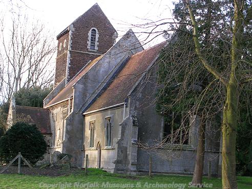
St Michael's Church, Ryston. (© NCC)
The earliest standing buildings in the parish date to the medieval period. St Michael’s Church (NHER
2472) is set within the park of Ryston Hall (NHER
2461) with the earliest parts of the church dating to the 12th century. The present tower, in vague Norman style, dates to 1858 and the rest of the church is 14th century in date but was restored in 1901. Of course this is not the only church in the parish as there is also St Mary’s in Bexwell (NHER
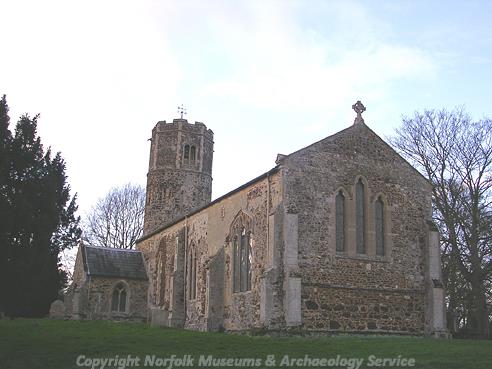
2470). This pretty church has a Norman round tower and a nave and chancel in one. The tower's octagonal top dates to the late 14th century and the church was altered in the 14th and 15th centuries before being thoroughly restored in 1874. Records also show that another church dedicated to St Michael (NHER
4464) existed in the medieval period although nothing of this building remains and the exact location of it is not clear.

St Mary's Church, Bexwell. (© NCC)
The parish of Ryston is also remarkable due to the fact that it possesses two deserted medieval village sites. The abandoned village of Ristuna (NHER
2453) lies 250m southwest of the works and pump on Ryston Road. It was mentioned in the Domesday Book of 1086 and the Nomina Villarum of 1316. Records state that the village was granted Black Death relief in 1352 but was depopulated by the 18th century. No buildings remain today, but east of the church are earthworks of a hollow way, ridge and furrow cultivation and possible house platforms. Less is known about the deserted village of Roxham (NHER
16534), situated to the south of Crossways Farm. It was seemingly deserted by the 16th century. No buildings remain, but from the air cropmarks are visible of roadways, enclosures and building plots.
A small selection of medieval finds has been found in Ryston. The majority of these are mundane items such as strap ends (NHER 41111), coins (NHER 40984), jettons (NHER 31096) and harness mounts (NHER 11464).
The post medieval period saw the erection of the magnificent Ryston Hall (NHER 2461). Sir Roger Pratt, a famous architect of the day, built this brick country house in about 1670 for himself. It has a north front of nine window bays with the central three bays projecting and is three storeys high, the lowest floor being a semi-basement. Alterations and remodelling were carried out in 1780 and 1867, which was probably when the yellow brick extensions at the east and west ends were added. In the grounds of the house are various outbuildings including stables barns, a cowshed, a summerhouse and an icehouse (NHER 2462). As was common of grand manor houses of the period the house was set in extensive parklands. Ryston Park (NHER 30521) was built for this purpose although it is now partly used as a modern golf course. It is also reputed that the large old oak tree in the grounds of Ryston Hall was a rallying point for rebels during Kett's Rebellion of 1549 (NHER 2466).
The other noteworthy building from this period in the parish is Bexwell Rectory (NHER 12231). This very fine Victorian Tudor-style building has a five bay façade, a battlemented porch and stepped gables. However, other than these two grand buildings, little else remains from the era and although a few post medieval artefacts have been found they are so archetypal so as not to merit a mention.
The latest archaeological records for Ryston deal with World War One military sites. The site of a World War One airfield (NHER 13614) has been identified on land near to Stonehills Farm. However, evidence suggests this was not in frequent use and served more as an emergency landing ground than an airstrip. It is also possible that one of the many possible Bronze Age ring ditches mentioned earlier (NHER 16169) may in fact be the marking ring belonging to a World War One landing ground.
Thomas Sunley (NLA), 10 April 2007.
Further Reading
Brown, P. (ed.), 1984. The Domesday Book (Chichester, Phillimore & Co.)
Pevsner, N. and Wilson, B. 1999. The Buildings of England, Norfolk 2: North-west and South (London, Penguin)
Rye, J., 1991. A Popular Guide to Norfolk Place Names (Dereham: The Larks Press)