This Parish Summary is an overview of the large amount of information held for the parish, and only selected examples of sites and finds in each period are given. It has been beyond the scope of the project to carry out detailed research into the historical background, documents, maps or other sources, but we hope that the Parish Summaries will encourage users to refer to the detailed records, and to consult the bibliographical sources referred to below. Feedback and any corrections are welcomed by email to heritage@norfolk.gov.uk
The coastal west Norfolk parish of North Wooton is situated immediately west of Sandringham. Its name comes from the Old English for ‘settlement in the woods’. The parish has a long history, and was certainly well established by the time of the Norman Conquest, its population, land ownership and productive resources being detailed in the Domesday Book of 1086.
The earliest evidence of human activity comes in the form of Palaeolithic flint handaxes (NHER 11344 and 13024) and a Neolithic flint knife (NHER 13024). Bronze Age finds are a copper alloy rapier tip (NHER 34683) and flint flakes (NHER 3310). A tree-covered mound (NHER 13899) on the heath east of the village has been interpreted as a much-mutilated Bronze Age barrow, but which could equally well be a natural feature. Aerial photography has identified a possible ring ditch (NHER 24974), the surviving traces of a flattened barrow. There is currently no evidence of Iron Age activity.
Roman finds include coins and a brooch (NHER 34683), together with pottery fragments (NHER 16822 and 24974). There is to date no evidence of Roman structures, but to the west of All Saints’ Church (see below) building works in the late 20th century revealed evidence of a metal working site (NHER 24120), including large quantities of iron slag, a possible furnace base and burnt clay. Roman pottery fragments were also found. The site is now largely built over. Aerial photography has identified a possible Roman or Saxon field system in the same area as the possible Bronze Age ring ditch at NHER 24974, and fragments of Saxon pottery have been recovered from there. The only other Saxon find is a strap fitting (NHER 36088) found by metal detecting in 2000.

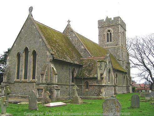
All Saints' Church, North Wootton. (© NCC)
Normally the medieval period leaves its parish church as the oldest surviving building, and there was indeed a medieval church on the site of All Saints’ (NHER
3294), but it had fallen into disrepair before being replaced by the current building in the 19th century. North of the church is the site of a medieval stone cross (NHER
3290), marked on old maps, but no trace of it remains today. What do remain, and in large numbers, are medieval saltern mounds, the traces of salt making works (examples of the many are NHER
36911,
36910 and
36906). Not always discernable on the ground, they have largely been identified by aerial photography.
Medieval objects consist of coins (NHER 34683 and 36088), pottery fragments (NHER 34683, 3291, 24974, 30826 and 31243), a token (NHER 36088) and a purse mount (NHER 16828).

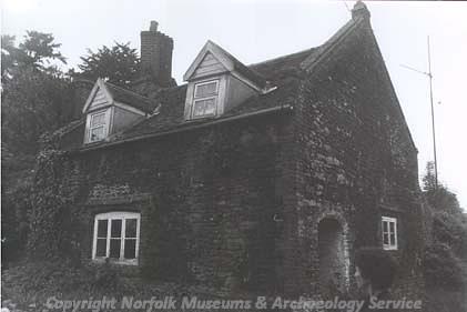
Church Cottage, North Wootton, a small carrstone building of about 1600, extended in the 19th century with some reused medieval stone. (© NCC)
Of the post medieval buildings to survive in the parish, probably the earliest is The Priory (NHER
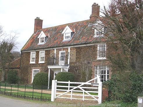
25338), sometimes known as Church Farmhouse. This is a double pile two storey carrstone and brick house with a date plaque of 1718 on its central columned doorway, though the front of the building is late 16th or early 17th century. The rear pile is later 19th century. Investigation during restoration work in the 1990s suggests a sequence of an early 17th century building, given a grand entrance and new windows in 1718, then a rear addition in the 19th century. Church Cottage (NHER
25337) on Nursery Lane is a small carrstone building of about 1600, extended in the 19th century with some reused medieval stone. The house was restored in the late 20th century.

The Priory, North Wootton. (© NCC)
Although largely gone now, various post medieval sea defences, flood banks and breakwaters are marked on old maps or are visible on 1940s aerial photographs (for example NHER
5528,
36937,
36927,
36913 and
36917).
A long rectangular tank (NHER 19578) was discovered during works at the pumping station in 1983. Its floor was paved in brick and its walls made of carrstone with brick tops. Apparently used as a sheep dip in the 1930s, it is possible that it was previously a retting or tanning pit.
NHER 2197 is the site of a windpump, marked on an early 19th century map. The site is now occupied by a small modern pumphouse. A windmill (NHER 36897) stood to the north of this, but no trace of it remains today.
The Lynn and Hunstanton Railway (NHER 13591) ran through the parish. This line was opened in 1862 and closed in 1969 (although King's Lynn station remained open, see NHER 13594). All of the railway track has been removed since 1969, although many buildings survive. These include stations at King's Lynn, Dersingham, Snettisham, North Wootton and Wolferton and several signal boxes.
All Saints’ Church (NHER 3294) was built in 1852 by Anthony Salvin for the Honourable Mrs Mary Howard at a cost of £2,200, about half a million pounds in today's money. It replaced a medieval church on the site that had fallen into disrepair. The style is very much Early English, with a grand west door flanked by niches and lots of blind arcading at the base of the tower. Plate tracery in the bell openings and nave and three narrow lancet windows to the east end complete the picture. The tower has a southwest turret which is capped in a Scottish baronial style popular at the time. Inside is a 19th century font with stylised foliage decoration, and the choir stalls are particularly worthy of note, their heads presumably those of parishioners; one has splendid muttonchop whiskers. The windows have later 19th century stained glass, including a rare figure of St Francis. The building is lit internally by very fine Art Nouveau lamp standards. In recent years, the base of the tower has been converted to a kitchen and meeting room.
North Wootton Bridge (NHER 43178) on Marsh Road is a reinforced concrete bridge of unusual design, over the Pinch Cut drain. It has a parapet of concrete posts and steel rails and is thought to have been built between 1910 and 1940.
During World Two the parish was home to various military installations. East of Wooton Marsh is the possible site of a World War Two Starfish decoy (NHER 23220). These were designed to fool enemy bombers into thinking they were bombed towns, with a variety of effects to represent both small fires and major conflagrations. This one was to protect King's Lynn. Other features of the time, now gone but visible on contemporary aerial photographs, include an artillery or bombing range (NHER 36921), a searchlight battery (NHER 36875) and anti-tank ditches (NHER 36873 and 36874).
This summary is very much intended as an overview, and those wishing to dig a little deeper should consult the detailed records.
Piet Aldridge (NLA), 3 November 2006.
Further Reading
Brown, P. (Ed.), 1984. Domesday Book; Norfolk (Chichester, Phillimore & Co)
Rye, J., 1991. A Popular Guide to Norfolk Place Names (Dereham, The Larks Press)