This Parish Summary is an overview of the large amount of information held for the parish, and only selected examples of sites and finds in each period are given. It has been beyond the scope of the project to carry out detailed research into the historical background, documents, maps or other sources, but we hope that the Parish Summaries will encourage users to refer to the detailed records, and to consult the bibliographical sources referred to below. Feedback and any corrections are welcomed by email to heritage@norfolk.gov.uk
The large parish of Halvergate is situated in the southeast part of Norfolk, immediately west of Great Yarmouth. Although covering an extensive area, much of the parish is uninhabited marshland, settlement being concentrated in the western part. The name’s origin is unclear, but may come from the Old English for ‘Land for which half a heriot (a feudal service or payment) is due’. The parish has a long history and was certainly well established by the time of the Norman Conquest, its population, land ownership and productive resources being recorded in the Domesday Book of 1086.
The earliest evidence of human activity in the parish comes in the form of a prehistoric but otherwise undateable flint flake (NHER 14775). There are no Palaeolithic or Mesolithic finds, and the next evidence comes from a few Neolithic finds, a flint axehead and flake (NHER 33279) and some pottery fragments (NHER 10369).
The Bronze Age has left the parish with possible evidence of its earliest structures. These are ring ditches, probably round barrows subsequently flattened by agriculture and only visible as cropmarks on aerial photographs. Quite a number of these have been identified in the parish, including NHER 11682, 14186, 18332 and 32060. The only other Bronze Age find in the parish is a copper alloy socketed axehead (NHER 17771). There are no Iron Age finds at present.
Work by the Norfolk National Mapping Programme (Broads Zone) in 2006/7 has indentified the cropmarks of a coaxial field system, of later Iron Age to early Roman/Roman date, covering large tracts of the landscape. There is very tentative evidence that the period of the Roman occupation may have left traces of a building. A scatter of Roman and medieval pottery fragments (NHER 14774) may indicate a building of either age. Other Roman finds in the parish include coins (NHER 15474, 33150, 33279 and 35199), pottery fragments (NHER 10370 and 33150), an armlet (NHER 31071) and a brooch (NHER 35720). Saxon finds are pottery fragments (NHER 21645 and 35369), a mount or brooch (NHER 33279), a strap end (NHER 34918) and a stirrup mount (NHER 37224). There is also evidence that salt was being produced from this period into medieval times. Aerial photography has identified numerous mounds that are associated with the heating and evaporation of sea water to obtain salt, a valuable commodity. Examples of these mounds include NHER 22349, 42196, 42197, 42198, 42199, 42399 and 42423.
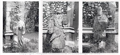
Three stone statues at SS Peter and Paul's Church, Halvergate. The statues originally stood at the top of the tower but were moved in 1958 to the base of the tower and by the porch. (© NCC.)
The medieval period has left the parish with its oldest surviving buildings, both dedicated to St Peter and St Paul. The church at Tunstall (NHER
10392) is a 14th century building on the site of an earlier church mentioned in the Domesday Book. Save for the chancel and a 19th century vestry, the building is in ruins, having fallen into disuse after the nave roof collapsed in 1660. Despite this, there is still an annual thanksgiving service in the chancel. To the south in Halvergate itself is the identically named NHER
10395, set behind a screen of lime trees with a very tall 15th century battlemented tower. The nave and chancel are 14th century, the south porch being added during an extensive Victorian restoration that also lengthened the chancel. Three stone statues that topped the tower until 1958 can now be seen at its base. There are interesting brasses inside, and a tiny but complete 14th century stained glass St Christopher, once in the north window, but now in a display case.
Other medieval structures have not survived, and their former presence can only be surmised by documentary evidence like old maps, or by scatters of medieval objects. An example of this is NHER 14773, a scatter of medieval finds in an area marked as Hall Piece on an old tithe map, and the possible site of medieval Wickhampton Manor. NHER 14774 referred to above is another scatter that may have been a medieval building, though it could equally well have been a Roman one. The traces of other medieval structures are invisible from the ground but can be made out from the air. An example is NHER 30301, the cropmark of a possible moated site. Aerial photography has also been valuable in identifying many other medieval features, including a large number of enclosures (selected examples being NHER 42179, 42180, and 42402) and, due to the marshy nature of much of the parish, drainage ditches (examples being NHER 42391, 42393 and 42395). However, it should be remembered that these features are not precisely dateable, and some may stray into the post medieval period. For instance, existing medieval drainage ditches will have been repaired, re - dug and improved well into post medieval times and indeed up to the present day.

Stracey Arms Mill, Halvergate. (© NCC.)
The marshy ground of the majority of Halvergate has since Roman times required drainage in order that the land could be used. This was achieved mainly by the drainage channels referred to above, but the post medieval period saw an increased use of wind power as a means of pumping water off the land. Some fourteen drainage windmills, both 18th and 19th century, serviced the marshes of the parish, eight of which survive. Probably the best known of these is the Stracey Arms (NHER
10387), a prominent and popular landmark in the surrounding flatness. This fine brick tower mill dates to about 1880, and was fully restored in 1961. Tunstall Dyke Mill (NHER
10384) was restored in 1994, as was Tunstall Dyke smock mill (NHER
10385), the only surviving drainage smock mill in Norfolk. Mutton’s Mill (NHER
10389), which has the only surviving scoop wheel in the Broads area, was restored in 1980. The other surviving drainage mills are High’s Mill (NHER
10403), South Walsham or Howard’s Mill (NHER
10404), Key’s or Black’s Mill (NHER
10407) and Six Mile House Mill (NHER
10408). Six drainage mills, marked on 18th and 19th century maps, have disappeared leaving little or no trace of their existence (NHER
10405,
15573,
15639,
18415,
18416 and
40394). In the southwest of the parish are the remains of Halvergate Mill (NHER
10391) a corn (as opposed to drainage) mill, dating to 1866. This was burnt out in 1935, and only the brick tower remains.
Of other post medieval buildings to survive, probably the oldest is Hall Farm Barn (NHER 43029), a 17th century thatched brick barn, partly rebuilt in the 18th century, and now with a 20th century galvanised steel extension. Dawdy’s Farmhouse (NHER 28692) is 18th century, but covers the remains of a 17th century timber framed building. The barn north of Halvergate House (NHER 43032), Horseshoe Barn (NHER 43033) and Harrier Barn (NHER 43034) are all 18th century thatched buildings, as is The Red Lion pub (NHER 43038). Manor House (NHER 43036) has a datestone of 1783. Hall Farmhouse (NHER 43028) is early 19th century, later refronted.
19th century buildings include Halvergate Hall (NHER 43030), built in 1840 for Sir Cyrus Gillet. Halvergate House (NHER 43031), with its symmetrical garden walls, was built at about the same time. Other 19th century buildings worth mentioning include Mill House (NHER 43037), Staithe Farm (NHER 43039), Stone Cottage (NHER 43040), Old Post Office (NHER 43041) and The Rookery (NHER 43042).
The most recent entries on the record for the parish date to World War Two. Two pillboxes (NHER 20339 and 20340) stand about two hundred metres east of the Red Lion pub, part of the anti invasion defences of 1940, and a Liberator bomber with a full complement of bombs crashed east of Tunstall in 1944 (NHER 15358).
Piet Aldridge (NLA), 12 April 2006.
David Gurney (NLA), 28 March 2008.
Further Reading
Brown, P. (ed.), 1984. Domesday Book, 33 Norfolk (Chichester, Phillimore & Co)
Rye, J., 1991. A Popular Guide to Norfolk Place Names (Dereham, The Larks Press)