This Parish Summary is an overview of the large amount of information held for the parish, and only selected examples of sites and finds in each period are given. It has been beyond the scope of the project to carry out detailed research into the historical background, documents, maps or other sources, but we hope that the Parish Summaries will encourage users to refer to the detailed records, and to consult the bibliographical sources referred to below. Feedback and any corrections are welcomed by email to heritage@norfolk.gov.uk
Dickleburgh and Rushall is a large parish in south Norfolk close to the Suffolk border. It is north of Brockdish and Scole. The parish has been formed by joining Dickleburgh and Rushall. There are several centres of modern occupation at Dickleburgh and Rushall themselves but there are also smaller hamlets including Dickleburgh Moor, Semere Green and High Common. Dickleburgh and Rushall are mentioned in the Domesday Book, as is Semere, which may be Semere Green. Both Dickleburgh and Semere were owned by the Abbot of St Edmund’s. All three villages have Old English origins for their names suggesting there has been occupation here since the Saxon period. Dickleburgh means ‘stronghold of a man called Dicel or Dicla’. Semere can be translated as ‘lake or marsh pool’. This fits well with the current location of Semere Green which is in the north of the parish in an area that was formerly marshy before extensive drainage. Rushall means ‘nook of land’. The first part of the word is probably a personal name. The archaeology of the parish includes significant evidence for prehistoric and Roman use of the landscape along with interesting medieval moated sites and more modern buildings.
The earliest evidence for activity in the parish is a Mesolithic axe (NHER 29524) recovered during the development of the Dickleburgh bypass. Fieldwalking ahead of the scheme also recovered several other prehistoric worked flints (NHER 23342, 23348 and 23354) and Neolithic flint flakes (NHER 28105) have also been found in the parish. Iron Age pottery (NHER 23353) has also been recovered. A burnt mound of flint (NHER 11014) has been recorded and a prehistoric crannog (NHER 11099), or man-made island has been reported near Dickleburgh Moor. This suggests this area was previously wetter before modern drainage. An undated wooden trackway (NHER 11012) seen in the sides of drains running north to south across this area may also be prehistoric. There has been considerable debate over the age of the relict field systems (NHER 7947) recorded in modern hedgerows and roads between Dickleburgh and Scole which were once thought to be prehistoric.
The Roman Pye Road (NHER 7947) cuts at an angle across this system, forming part of the eastern boundary of the parish. Another possible Roman road, Patten Lane (NHER 11022), joins the Pye road at Dickleburgh although excavations here suggest the current road is Saxon or later. There are extensive scatters of Roman pottery (NHER 11010, 23343, and 28497) across the area – fragments were found at many of the fieldwalking sites along the Dickleburgh bypass. Other Roman finds include a 1st century AD Dolphin type brooch (NHER 36092), a terret attachment (NHER 32743) for a chariot and several Roman coins (NHER 29525, 35916 and 36092) including a silver denarius of Julius Caesar (NHER 11011) minted in 45 BC.

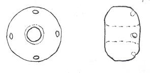
Saxon spindle whorl found in Dickleburgh. (© NCC)
In the Saxon period there seems to be a decrease in archaeological evidence, although this doesn’t necessarily indicate a reduction in human activity in the area. A Late Saxon spindle whorl (NHER
17652) and a Late Saxon stirrup mount (NHER
36092) are the only recorded Saxon finds from the parish although we know this is likely to be the date of settlement in at Dickleburgh, Semere Green and Rushall. The round tower of St Mary’s church, Rushall (NHER
11037) may be Saxon supporting a Saxon date for the settlement here.
In contrast to the lack of evidence for Saxon sites there are six medieval moats (NHER 11030, 11025, 11031, 11032, 11034 and 11087) in the parish. The large number is partly because of the water retentive clay geology of the landscape that is particularly suited to the construction of this type of monument.

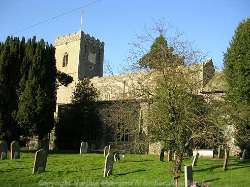
All Saints' Church, Dickleburgh. (© NCC)
All Saints' Church (NHER 3991) also dates to this period and several hall houses (NHER 19401 and 24915) built around 1500 survive, albeit considerably converted and altered. Parts of Scotland Yard (NHER 28649) possibly date to 1400. Earthworks of medieval house platforms (NHER 20140) and scatters of medieval pottery (NHER 29525) suggest other areas of occupation.

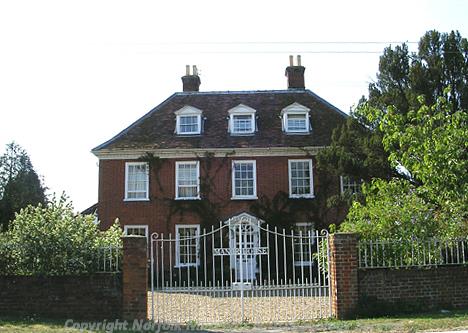
Manor Farm in Dickleburgh is a mid 17th century timber-framed farmhouse. (© NCC)
There are many post medieval buildings surviving in both Dickleburgh and Rushall. The old King’s Head Inn (NHER
42781) is a timber framed building that may date back to the 15th century. Manor Farm (NHER
35089) is a mid 17th century timber-framed farmhouse.

Dickleburgh House is a grand 18th century brick manor house. (© NCC)
Dickleburgh House (NHER
15513) is a grand 18th century brick manor house. The Old School (NHER
3990) was built in the churchyard in the 19th century and the Baptist chapel (NHER
3992) is of similar date. Dickleburgh Hall (NHER
12400) was built in the 16th century and has been derelict until it was converted into a small country hotel. The village has had a series of mills (NHER
16403,
16404 and
11010). The latest was built as recently as 1919. None of these remain. Thorpe Abbotts Airfield (NHER
15169), in the north of the parish, used by the United States Army Air Force during World War Two can still be visited as the control tower and various other buildings have been converted into a museum. A pillbox (NHER
32719) can also be seen to the east of Dickleburgh village on the Langmere Road.
There is extensive use of the landscape in this parish from the prehistoric period to the development of the airfield in the 1940s. The lack of Saxon archaeology doesn’t necessarily indicate lack of activity but perhaps a lack of archaeological research.
Megan Dennis (NLA), 29th September 2005.
Further Reading
Brown, P. (ed.), 1984. Domesday Book, 33 Norfolk, Part I and Part II (Chichester, Philimore)
Knott, S., 2005. ‘All Saints Dickleburgh’ Available:
http://www.norfolkchurches.co.uk/dickleburgh/dickleburgh.htm. Accessed 1 February 2006.
Mills, A.D., 1998. Dictionary of English Place Names (Oxford, Oxford University Press)
Peterson, J., 1997. ‘Ancient Landscape in South Norfolk’. Available:
http://www.sys.uea.ac.uk/Research/researchareas/JWMP/venta5.html. Accessed 1 February 2006.
Rye, J., 2000. A Popular Guide to Norfolk Place-names (Dereham, The Larks Press)
Williamson, T., 1993. The origins of Norfolk (Manchester, Manchester University Press)