This parish summary provides an overview of the large amount of information which we hold about the parish, and only a representative sample of sites and artefacts from each period are mentioned. If you have any feedback on this article please contact us using the link on the left-hand menu or by emailing heritage@norfolk.gov.uk
Attleborough is a large parish located in central southern Norfolk. It is in the Breckland district, about 14 kilometres northeast of Thetford and about 15 kilometres southwest of Norwich. Rivers and streams form part of the southern and western parish boundaries, whilst a stream passes northeast to southwest through the middle of the parish. The other parish boundaries follow roads, field boundaries, Bunn’s Bank or cut across landscape features.
Attleborough town occupies the centre of the parish, and is located between the A11 (the main Norwich to London road) and the Norwich to Ely railway line. The A11 passed through the centre of the town until a bypass was built in the 1980s. The B1077 Diss to Watton road still does, following a one way system around the town centre. As well as the town, farms and hamlets are scattered throughout the parish. These include West Carr, Fiddler’s Green, Baconsthorpe and Burgh Common.
A reasonable amount of archaeological work has been carried out. This includes work ahead of development, work ahead of improvements to the A11, building recording, fieldwalking and metal detecting. Although much of the parish has been covered, a number of areas have not been examined (such as between West Carr and Swangey Fen). As the distribution of archaeological finds appears to reflect the areas studied, this means identifying changes in occupation, activity and settlement is difficult.
The earliest artefact recovered to date is a Middle Palaeolithic flint handaxe (NHER 25257), discovered close to the A11 in 1989. Other prehistoric flint artefacts found include scrapers, flakes, arrowheads, flaked and polished axeheads, an axehammer and burnt flint. The distribution of prehistoric flint artefacts and pottery corresponds fairly closely to the distribution of fieldwork sites. This is also the case when the distribution of prehistoric finds is separated out into the Neolithic, Bronze Age and Iron Age periods.
Eight sites have revealed evidence for prehistoric burnt mounds or hearths. It is interesting to note that all are located close to rivers or streams. The only excavated features of definite prehistoric date are a Late Bronze Age or Iron Age pit and two ditches (NHER 39690) found close to one of the burnt mound sites. Two groups of possible prehistoric monuments are situated away from water. These are a ring ditch to the northwest of the town and three possible ring ditches to the southeast. All may be the remains of Bronze Age barrows, although those in the southeast may be modern ‘crop circles’.
Plenty of Bronze Age metalwork has been collected. The assemblage includes palstaves, socketed axes, a flat axehead, a spearhead and a pin. Four socketed axes found at a site (NHER 30938) to the north of the town may have been part of a hoard. In 2003 a rare Late Bronze Age to Early Iron Age bone or jet toggle (NHER 39690) was found in an excavated feature. A Late Bronze Age or Iron Age razor has recovered in the south and one silver Iron Age coin has been discovered, although where this was found is uncertain.
The distribution of Roman artefacts also matches that of fieldwork. Perhaps the most interesting find of this date was found in 1963 during the digging of a pipe trench. This is a group of Roman pewter plates that was probably deposited as part of a hoard (NHER 9188), with additional pieces found in 1986 recorded as NHER 24076). The only certain Roman feature is a wall (NHER 9095) containing roof and flue tiles. This was found in 1962 during drain digging to the northwest of the town. It is thought that two undated roads in the parish may have Roman origins. One survives as an undated bank and ditches (NHER 4380) to the north of the A11, while to the south of the A11 the other is known from cropmarks visible on aerial photographs.
As only a few Early Saxon artefacts have been found, it is difficult to interpret their distribution. However, pottery found in St Mary’s churchyard (NHER 38058) in the centre of the town might suggest the presence of settlement in the Early Saxon period. Bunn’s Bank (NHER 9206), a bank and ditch on the southeastern boundary of the parish, could have been constructed to mark the boundary of an Early or Middle Saxon estate. However, in the medieval period it was used as to demarcate the northern boundary of Buckenham deer park and it may have been constructed after the Norman Conquest for this purpose.
Few Middle Saxon objects have been discovered. As most sites have only revealed one object, it is difficult to identify patterns of activity. More Late Saxon objects are known, but their findspots tend to match the pattern of fieldwork. Pottery found in St Mary’s churchyard (NHER 38058) could suggest that the centre of the town was settled during the Late Saxon period. The largest number of finds (pottery, a brooch, weights, a possible Thor's hammer and a coin) has come from a site situated to the north of the town. This potentially interesting site has also yielded possible Middle Saxon objects.
Attleborough appears in the Domesday Book as ‘Atleburc’ and ‘Alio Atlebur’ (‘the other Attleborough’). In 1086 Roger, son of Rainard, held land in both and Alfred held land in ‘Atleburc’. Freemen, villagers, smallholders, slaves, meadow, ploughs, woodland, pigs, cattle, goats, sheep a mill and a fishery are listed. ‘Atleburc’ is an Old English placename meaning ‘Aetla’s stronghold’.
The tower is the earliest part of St Mary’s Church (NHER 5565). It was built not long after the Norman Conquest, either in the late 11th or 12th century. The tower was heightened during the 13th century and the nave, aisles, chancel and transepts were constructed between the late 14th and mid 15th centuries. The east end of the church was used by the College of the Holy Cross from about 1400 until its dissolution in 1540.

The 20th century mock tudor facade of the Attleborough community centre which conceals a 16th or 17th century timber framed building (©NCC)
Attleborough developed as a town during the medieval period and was locally successful by the 13th century. Townspeople were granted the right to hold a market by Edward I and Queen’s Square (NHER 5563) in the centre of the town was the medieval market place. A medieval market cross stood in the square (where a Victorian water pump now stands) until it was removed in 1787. Attleborough still has a weekly market (held every Thursday). The 20th century facade of the community centre (NHER 41241) hides a much earlier 16th or 17th century timber framed building.
A cess pit and pottery (NHER 41824) found during a watching brief north of the church are evidence of medieval activity within the town centre. Medieval ditches (NHER 35169) found northwest of the modern town centre may have been boundaries to fields on the edge of the medieval town. Medieval and post medieval artefacts have been found in all the areas where fieldwork has been carried out.
To the northeast of the town is a medieval moated site (NHER 7009). The post medieval Attleborough Hall now stands on the platform within the moat. It has beams that may come from the medieval manor house and a summerhouse contains medieval stonework. A second moated site (NHER 20087) is located to the west of the town at the hamlet of West Carr.
The settlement of Baconsthorpe is also listed in the Domesday Book. It is called ‘Baconstorp’ and was held in 1086 by Count Alan. Smallholders, meadow, woodland, a plough and pigs are recorded. Unfortunately the site of the 11th century settlement is unknown, although the placename is used for an area of housing, a farm and a bridge to the north of the town. These features are located about 700m to the west of Attleborough Hall moated site. Perhaps the moated site was associated with Baconsthorpe.
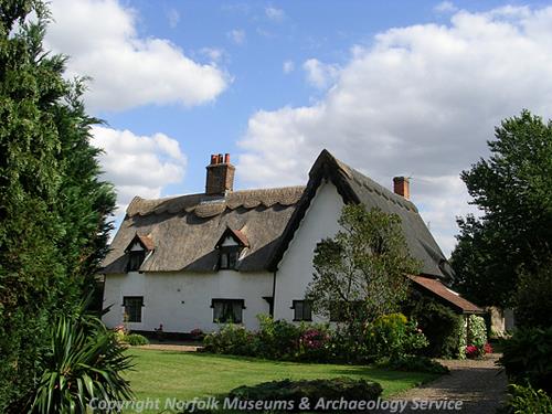
The Thatched Cottage on Connaught Road, Attleborough (©NCC)
Undated foundations found during ploughing at Burgh Common could be from a medieval or post medieval building. To the south of the town undated cropmarks of a hollow way, a square enclosure and a possible field system may be medieval in date, although they need not be. The same is true of a square enclosure cropmark identified close to the present A11.

The former Corn Hall in Attleborough (©NCC)
Attleborough continued to function as a successful market town during the post medieval period. Many post medieval buildings survive within the town centre, including the Old Bear Inn, the Griffin Inn, Whitehouse Cottage, Thatched Cottage and Central House. There is an 18th or 19th century terrace (NHER 5562) on Queens Square, one building of which is now Attleborough Town Hall. Close by is a 19th century building that was originally the town’s Corn Hall (NHER 5560). A number of post medieval buildings demolished during the 1970s were recorded before demolition took place. Further post medieval buildings survive in the modern suburbs and the less built up areas of the parish. These include Borough Farm, Potmere Farm, West Farm, Sherbourne House, Arosa, Cyprus House and Attleborough Hall.
The Wayland Union workhouse (NHER 15965) is shown to the west of the town on a map dating to 1836. In 1911/1912 to the north of this, and to the northwest of the town, a Poor Law infirmary (NHER 34339) was built. The infirmary later became the Wayland Hospital.
At the beginning of the 19th century Attleborough had at least two windmills, one to the northwest of the town (NHER 15294) and one to the southwest (NHER 15302). The northwestern windmill was replaced by a third mill (NHER 15506) in 1804 and a fourth was built to the south of the town during the early 19th century. Industry developed in the south of the town close to the railway during the 19th century. Two brickworks, a granary and maltings complex are recorded; the granary and maltings (NHER 11806) survived until they were destroyed by fire in 1977. Two saw pits sited to the north of the town are also recorded.
In the late 1850s a war memorial (NHER 5567) was built in the south of the town to commemorate the end of the Crimean War. It is one of only a few monuments to the Crimean War in Britain. In 1940 a World War Two pillbox was built beside the memorial. There was a second World War Two pillbox on the northern side of the A11 (NHER 32715) northeast of the town. Both pillboxes were demolished after the war.
David Robertson (NLA), 24 October 2005.
Further Reading
Anonymous, 1976. St Mary’s Church, Attleborough: A guide.
Brown, P. (ed.), 1984. Domesday Book: Norfolk (Chichester, Phillimore)
Bujak, P., 1990. Attleborough, the evolution of a town (Cromer, Poppyland)
Mills, A.D., 1998. Dictionary of English Place-Names (Oxford, Oxford University Press)
Norfolk Federation of Women’s Institutes, 1990. The Norfolk Village Book (Newbury, Countryside Book)
Rye, J., 1991. A Popular Guide to Norfolk Place-names (Dereham, Larks Press)
Spider Solutions, 2006. 'Attleborough online'. Available: http://www.attleboroughonline.co.uk/. Accessed 12th January 2006.