This Parish Summary is an overview of the large amount of information held for the parish, and only selected examples of sites and finds in each period are given. It has been beyond the scope of the project to carry out detailed research into the historical background, documents, maps or other sources, but we hope that the Parish Summaries will encourage users to refer to the detailed records, and to consult the bibliographical sources referred to below. Feedback and any corrections are welcomed by email to heritage@norfolk.gov.uk
Potter Heigham was originally referred to simply as Heigham, and is derived from Old English terms which indicate a homestead with a hedge, or with a grating used to catch fish. By 1182 it was referred to as Heigham Potter, due to the extensive manufacture of pottery taking place in the ‘Pothills’ area in the very northwestern corner of the parish (NHER 8388). By 1797 the village had become known as Potter Heigham, though the marshes retained the older Heigham Potter name.
The present settlement has three foci; around the church, in the area around the former vicarage to the southwest, and in the area once known as Heigham Falgate, as well as recent service buildings at the bridge. 20th century settlement has taken place almost entirely around the area of the former vicarage. To the north Potter Heigham parish encompasses some of Hickling Broad and nature reserve, including the Candle Dyke and Duck Broad section. To the east the parish is bordered by the Eelfleet Wall drain, and the whole southeast side is bounded by the River Thurne. On the banks of Hickling Broad is the Sound Plantation, and the parish is cut south to west by the A149 road, as well as being criss-crossed by numerous banks and drains. Potter Heigham has an area of 10.38 km2, with a population of just over 900, and is part of the North Norfolk local government district.
Archaeological evidence for Potter Heigham has an unusual distribution. So far only a single metal detecting event has taken place in the parish. As a result, the number of artefacts recovered from this parish is significantly lower than the majority of other parishes in the county.
The largest number of finds have been recovered by the NAU during a programme of fieldwalking and metal detecting in advance of the construction of the Bacton to Great Yarmouth gas pipeline in 1997 (NHER 33999 to NHER 34004). As a result, the only evidence for prehistoric activity in this parish is derived from that programme. Pot boilers were found in almost all areas (NHER 34000 to NHER 34004), as well as worked flints (NHER 34002) and even prehistoric pottery (NHER 34001) which is usually particularly rare. It seems likely therefore that if similar investigations were carried out in other areas of the parish, evidence of prehistoric activity would be more numerous.
Specific evidence for Bronze Age period activity in Potter Heigham is limited to a single copper alloy palstave dredged out of Hickling Broad (NHER 8387), and there have been no artefacts recovered that can be confidently dated to the Iron Age. Only one site with Roman artefacts has been found, in the village area just south of the A149 (NHER 12708), but it is of great interest. In 1972 three copper coins and ‘half a barrow load of old leather and iron buckles’ were recovered from a waterlogged site during the construction of a soak-away. The coins and buckles were subsequently identified as Roman, although the leather perished before it could be conserved and analysed. Had it been saved, who knows what we might have discovered.
There is unfortunately no evidence for occupation or exploitation of the area during the Saxon period. The Domesday Book does mention the parish, but it lists only two people and puts very little value on their land, making no mention of anything that we might expect, such as a mill, a fishery, church or plough. However, St Nicholas’ Church (NHER 8543), sited just north of the current village, originated in the 12th century, which seems to suggest that growth in this parish took place in the early medieval period. This is a direct result of the peat digging industry of the 12th to 14th centuries, which provided one of the most important fuels in an area that was one of the most densely populated in England.
Operating in the same time period was the pottery works (NHER 8388) in the northwest corner of the parish very close to Hickling Broad. As mentioned earlier, it is this pottery works that gives Potter Heigham its full name. When the site was first discovered in the 1820s it was initially thought to be Roman, as the majority of sites were in those days, but it was in fact active between the 12th and 15th centuries. When it was discovered mounds of black soil were found, littered with fragments of pottery, however little remains of these today.
At the same time as the peat digging and pottery industries were at their height, a bridge was also built over the River Thurne (NHER 8525). Dating to the 13th or 14th century, it is situated on the main road between Great Yarmouth and North Walsham, and links Potter Heigham with the parish of Repps with Bastwick. It is listed grade II, and in its current form is 14th century with 15th century central arch and buttresses.
Unfortunately for the parish, the peat diggings which proliferated across the north (NHER 27280, NHER 8387, NHER 43725) began to fill with water in the 14th century. Drainage ditches (NHER 27280) were cut, but by the 15th century were completely flooded, leaving behind lakes such as Hickling Broad (NHER 8387). It is during this period that the church of St Nicholas (NHER 8543) received some of its most charming features, making it one of the nicest churches in the Broads. The round tower dates back to the 12th century, with a 14th century embattled octagonal top which is one of the best preserved in the country. All of the roofs are still thatched, and when it was recently rethatched it required about 1850 bundles of reed. Inside there is a stunning example of a hammerbeam roof, as well as an almost unique 15th century brick font and a scheme of 14th century wall paintings in both aisles, the most readable of which are the Seven Works of Mercy.
Indeed, little work has been undertaken since the end of the 16th century, and the church even avoids the usual over enthusiastic and misguided Victorian attempts at ‘restoration’. The decline in additions to the church is reflected across the parish, where the flooding of the peat cuttings appears to have brought about a decline in the fortunes of the parish. Faden’s map of 1797 shows a very different parish, with extensive marshland and flooding visible.

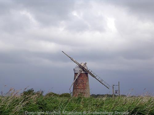
The mid 19th century wind pump at Heigham Holes. (© NCC)
Activity in the parish seems to have changed by this time to include grazing of cattle on the marshland linked with the drainage that began in the 18
th century. During this period large numbers of drainage ditches (NHER
43716, NHER
43720) were dug and mills constructed to move the water from the land, up to the rivers. Of these two are listed; Heigham Holes Windpump (NHER
8392) on the easterly edge of the parish, and High’s Mill on the River Thurne. Also surviving are a number of drainage pumps (NHER
12705, NHER
18892), and Sunways Mill (NHER
8540), a grade two listed wind-powered corn mill, whose present six storey tower was built in 1849 to replace an earlier post mill.
Although there are other structures such as Martham Ferry Bridge (NHER 33880), 2.75 km from the medieval Potter Heigham bridge, the listed sites of the post medieval period are dominated by agricultural buildings such as Dovehouse Farm (NHER 12097), Bethel Hospital Farmhouse (NHER 46640), Clay Barn (NHER 47426) and Rookery Farmhouse (NHER 47634), indicating the importance that agricultural activities came to have during this period.
In 1845 a large portion of the parish was held by leaseholders under the Bishop of Norwich, who was also the lord of the manor. This may be a hangover from the church’s control of peat cutting in the medieval period, and although there was a hall of some form at Potter Heigham, now called Hall Farm, there are no records of it. As with many other periods, the small number of finds recovered from this parish are largely associated with the programme of work in advance of the Bacton to Great Yarmouth pipeline, so very little can be interpreted from this limited evidence.

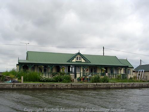
One of the distinctive inter-war chalets built in vernacular style on the River Thurne. (© NCC)
However, the parish of Potter Heigham does have a large number of features associated with the World Wars. Due to the parish’s position close to the North Sea and its flat landscape there are a number of airfields. Part of Ludham Airstrip (NHER
8456) is in Potter Heigham parish, and this contained a number of earthworks, structures and defences (NHER
45048, NHER
45047) used in World War Two. Of the same period are a number of bomb craters (NHER
44916, NHER
43715) and defences surrounding Potter Heigham Bridge (NHER
45066). Hickling Broad itself was even used as a seaplane base during World War One (NHER
8387), and perhaps most intriguingly there is evidence that the SOE (Special Operations Executive) used a field in Heigham Holmes as a secret airfield from which agents were flown into occupied countries during World War Two (NHER
25538). After the war the area became popular for holiday makers. recorded buildings include good example of early holiday chalets (NHER
39354).
The lack of finds in Potter Heigham makes it difficult to interpret activity during the pre-medieval periods, though this may be largely related to the paucity of metal detector use in the parish. The lack of evidence does not necessarily indicate a lack of activity, particularly when Potter Heigham is so rich in earthworks and cropmark evidence. Aerial photography of the region has occurred irregularly since World War Two, and the recent Norfolk National Mapping Project has identified over forty-five separate sites of earthworks or cropmarks. The majority of these cannot be firmly dated, and may represent anything from prehistoric enclosures (NHER 43792) to Roman ditches (NHER 43795) or post medieval turf extraction (NHER 43700). What they do tell us is that despite the lack of finds there certainly was activity in Potter Heigham not limited to the boom-time period of peat extraction.
Ruth Fillery-Travis (NLA), 7 December 2006.
Further Reading
GENUKI, Information on Potter Heigham. Available:
http://www.origins.org.uk/genuki/NFK/places/p/potter_heigham/. Accessed: 7 December 2006
Marhsall, A., Associate Lecturer, The Open University (United Kingdom), May 2006. 'The Seven Works of Mercy, Potter Heigham, Norfolk’. Available:
http://www.paintedchurch.org/pottheig.htm. Accessed: 7 December 2006
Morris, J. (General Editor), 1984. Domesday Book, 33 Norfolk, Part I and Part II (Chichester, Phillimore & Co)
Mortlock D. P. & Roberts, C. V., 1981. The Popular Guide to Norfolk Churches No. 1, North-East Norfolk (Acorn Editions)
Neville, J., 2004. ‘Potter Heigham towermill’. Available:
http://www.norfolkmills.co.uk/Windmills/potter-heigham-towermill.html. Accessed: 7 December 2006
Pevsner, N., 1997. The buildings of England: Norfolk 1: Norwich and North-East (London, Yale)
Rye, J., 1991. A Popular Guide to Norfolk Place Names (Dereham, The Larks Press)
Sinclair, O., Unknown. Potter Heigham - The Heart of Broadland (North Walsham, Poppyland Publishing)
Southall, H., 2006 ‘A Vision of Britain Through Time: Potter Heigham CP’. Available:
http://www.visionofbritain.org.uk/relationships.jsp?u_id=10208749. Accessed: 7 December 2006
William White's History, Gazetteer, and Directory of Norfolk, 1845