This Parish Summary is an overview of the large amount of information held for the parish, and only selected examples of sites and finds in each period are given. It has been beyond the scope of the project to carry out detailed research into the historical background, documents, maps or other sources, but we hope that the Parish Summaries will encourage users to refer to the detailed records, and to consult the bibliographical sources referred to below. Feedback and any corrections are welcomed by email to heritage@norfolk.gov.uk
New Buckenham is a small parish in the Breckland district of Norfolk. It is located southwest of Old Buckenham and northeast of Tibenham. The village was created between 1146 and 1176 by William D’Albini as a Norman planned town. He placed New Buckenham on a virgin, undeveloped site adjacent to his new castle (NHER 40577). The village name derives from that of its neighbour Old Buckenham. The origins of the name are Old English and can be translated as ‘homestead of a man called Bucca’. The village, together with its eastern neighbour New Buckenham has a fascinating medieval history that is amply recorded in documents. The records for these two parishes are so closely linked that some finds and sites officially located in Old Buckenham civil parish have been included here to present a coherent summary. The documentary record has been investigated over many years by Paul Rutledge. The Norfolk Historic Buildings Group has also carried out a long term building survey including dendrochronological dating of samples from the many timber framed buildings of the town. The earlier history of the landscape is less well known.
The earliest find recorded in the database is a Neolithic axehead (NHER 9194). Several other undated prehistoric worked flints (NHER 30609 and 39661) have also been found. Traces of Bronze Age barrows (NHER 9195) were recorded in the 19th century on Buckenham Common but no trace of them can be seen now. The site of two possible Bronze Age barrows (NHER 9196) was recorded in the 19th century but the mounds are no longer there. Prehistoric pot (NHER 40629) has also been recorded. Fieldwalking in part of New Buckenham Castle’s southwest bailey just outside the parish boundary recovered pieces of Iron Age pot (NHER 40624).
A possible Roman road (NHER 9219) has been reused as part of the parish boundary. Pieces of Roman pot (NHER 40624) have been found close to New Buckenham Castle (NHER 40577) and a Roman coin (NHER 9197) was found in the parish before 1952. Pieces of Middle and Late Saxon pot (NHER 9200) have also been found within the town.
New Buckenham Castle (NHER 40577) is actually in Old Buckenham parish but for the sake of completeness will be described here. The D’Albini’s established this substantial castle around 1146 to replace Old Buckenham Castle (NHER 9202). The circular ringwork of New Buckenham Castle contains the oldest, and perhaps the largest, circular Norman keep in the country. The castle has two baileys. The east bailey (recorded as Knightriders Ward in an old document) is the earliest. It was reached via an east gateway that was destroyed in the 13th century when the bank of the ringwork was enlarged almost burying the gatehouse. A second bailey, gatehouse and barbican-like defensive enclosure were then constructed to the southwest. The castle was besieged twice in the 13th and 15th centuries. It was defortified in the 1640s. St Mary’s Chapel (NHER 39594) is adjacent to the castle. William D’Albini founded this in the 12th century to serve the parishioners of his planned town (NHER 9200) and the inhabitants of his castle (NHER 40577). At some stage in its history it was served by the canons of St James’ Priory. When the parish church of St Martin (NHER 40579) was built in New Buckenham in the 13th century the chapel became the private chapel of the castle. At some time in the 15th century large traceried windows were inserted. The chapel appears to have survived the Reformation, perhaps continuing in use until the defortification of the castle in 1649. The castle and chapel were surrounded by Buckenham deer park (NHER 44620) that was laid out around 1100 to surround Old Buckenham Castle (NHER 9202). D’Albini’s son, William the Strong, expanded the park in the 12th century probably as part of his development of New Buckenham Castle (NHER 40577) and the planned town (NHER 9200).

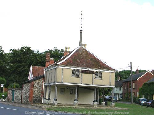
The 16th century timber framed market cross in New Buckenham. (© NCC)
New Buckenham was laid out as a rectangular planned and fortified Norman town on a simple grid pattern attached to the D'Albini's castle (NHER
40577) in Old Buckenham parish between 1146 and 1176. It functioned as a small borough and market town. This is a remarkable example of a planned town that has generally kept to its original boundaries and layout. The town was surrounded by a rectangular boundary ditch (NHER
41233).
The small size of the town meant that in order to create a decent sized field for the townspeople to graze their animals, William had to borrow land from the Bishop of Norwich. Haugh’s Enclosure (NHER 31005), an oval piece of ground surrounded by a ditch to the southeast of the town was borrowed from the Bishop. This had originally been an outlier of the Bishop’s manor at Eccles. Parts of the ditches around this ‘borrowed’ town field still remain. A second area to the north of the town was also taken over effectively becoming a second town field. Most residents of New Buckenham also had rights of access to the common to the east of the town. The acreage was, however, too small to support all the people of the town and consequently many had a non-agricultural trade for income.
In the 13th century St Martin’s Church (NHER 40579) was created. This replaced St Mary’s Chapel (NHER 39594) as the town’s place of worship. The building of the new church may have been stimulated by a growth in population. The new building was inserted into an empty space on the town grid to the north of the market place. This church was founded in the 1240s, between 50 and 100 years after the laying out of the town. Only parts of the chancel and possibly the base of the tower now date to this period. The south doorway and perhaps the south arcade were built around 1300 to 1330 and the north aisle and chapel in the late 15th century. The tower, south aisle, clerestory and chancel belong to a grand rebuilding in the early 16th century.

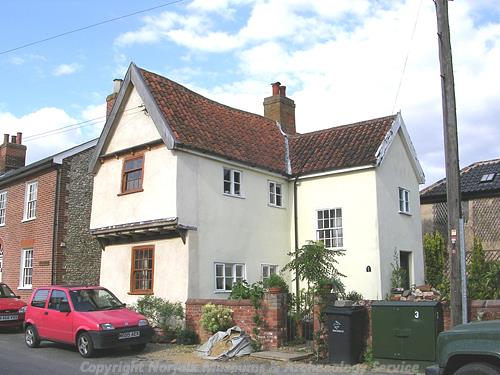
1 Chapel Street is a 16th century timber framed house that was probably originally a gatehouse. (© NCC)
A large part of the housing within New Buckenham dates to the late 15th and early and mid 16th centuries. The size of the market place was reduced in the 15th century to provide further sites for high status houses for example No.3, Oak Cottage and Priory Cottage (NHER
40616), the earliest jettied building still standing in the town. The number of people involved in trading led to the predomination of forms of housing that emphasised storage space. The medieval tripartite plan of parlour, hall, and service wing was often adapted. For example at The Pleasance (NHER
40608) an extra wide doorway was incorporated into the tripartite plan to allow access to the market place and make it easier to move bulky items in and out of the building.
The hall and service plan was also used in buildings in the town. Dial House (NHER 40621) is the earliest building to use this plan and was built around 1500. It had an extremely large hall that, again, was probably adapted this way to create more storage space. Another two-cell plan house, Gingerbread Cottage (NHER 41041) still contains a 16th century plank and muntin screen constructed from local oak on the upper floor. This is the only example of this type of screen known in Norfolk.
It is unsurprising that medieval pot has been found in many of the gardens of New Buckenham. A medieval copper alloy seal (NHER 13739) was found 'on estate at New Buckenham formerly Lord Petre's, now belonging to Sir T. Baring'.
Some tradesmen in the town did very well for themselves during the early post medieval period and were able to create very upmarket houses. Pinchpot (NHER 40585) is an early example of a lobby entrance house. It contains some exquisite wood and plaster work. The name is derived from the 17th century owner, Widow Stacy, who had a habit of pinching the leather pot at The Bull Inn to increase the profit margin on her beer. Turnpike Lodge (NHER 41042) also contained many cutting edge features for the time. It is built on the same basic plan as Pinchpot but there is some reused timber in the house that may relate to an earlier building on the site. As the town grew the south town boundary ditch (NHER 41233) was infilled. Parts of the ditches remain as open water because they were used in the 16th century as tanning pits.
After economic decline in the 18th century housing was repaired and renovated in the town rather than knocked down and rebuilt. In some cases the rows of terraced buildings allowed reallocation of rooms between neighbouring houses. One good example is The Old Swan, Diken Cottage and The Beams (NHER 40617). In the 19th century many houses were clad with a brick façade hiding the timber frames and disguising many of the medieval buildings (NHER 41041, 40621 and 40608).

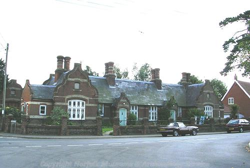
The almshouses on Castle Hill Road were built in the late 19th century. (© NCC)
Although many post medieval structures in New Buckenham survive, the two windmills on the common (NHER
15303) were both demolished by 1920. Post medieval cobbled surfaces have also mostly been replaced but excavation on the former site of the garage and bus depot (NHER
40633) recorded post medieval cobbled surfaces and post medieval finds including a tyg (two handled drinking vessel). Excavations have also uncovered a post medieval midden (NHER
44515) in the front garden of Mill House and evidence for industrial activity at The Old Police House (NHER
40629). An 18th century milestone (NHER
41289) inscribed NORWICH 15 MILES ATTLEBORO 5 MILES still stands on Common Road.
The Wesleyan chapel (NHER 40582) went into disuse when a new chapel was built in Chapel Street. It seems to have been used later as a school and then a house. The building was demolished in 1985. The telephone box (NHER 43200) in the centre of the town was designed in 1936. It is now listed and protected by English Heritage. There is a World War Two Royal Observers’ Corps post (NHER 44632) near Spitalmere. Excavations at the former snooker hall uncovered two modern dog skeletons (NHER 39661) that were originally thought to be medieval burials! The most recent archaeological site is a Cold War Royal Observers Corp post (NHER 11809) on Buckenham Common. An Orlit post structure and an underground chamber were constructed here in 1960 and served until 1968.
Megan Dennis (NLA), 16 May 2006.
Further Reading
Brown, P. (ed.), 1984. Domesday Book, 33 Norfolk, Part I and Part II (Chichester, Philimore)
Knott, S., 2006. ‘St Martin, New Buckenham’. Available:
http://www.norfolkchurches.co.uk/newbuckenham/newbuckenham.htm. Accessed: 15 May 2006.
Longcroft, A. (ed.), 2005. 'The Historic Buildings of New Buckenham', Journal of the Norfolk Historic Buildings Group Volume 2 (Norwich)
Mills, A. D., 1998. Dictionary of English Place Names (Oxford, Oxford University Press)
Rutledge, P., 2000. New Buckenham A Planned Town At Work 1530-1780 (Norfolk Archaeological and Historical Research Group)
Rye, J., 2000. A Popular Guide to Norfolk Place-names (Dereham, The Larks Press)