This Parish Summary is an overview of the large amount of information held for the parish, and only selected examples of sites and finds in each period are given. It has been beyond the scope of the project to carry out detailed research into the historical background, documents, maps or other sources, but we hope that the Parish Summaries will encourage users to refer to the detailed records, and to consult the bibliographical sources referred to below. Feedback and any corrections are welcomed by email to heritage@norfolk.gov.uk
The parish of Belton and Browston is situated on the Norfolk – Suffolk border, north of the River Waveney and west of Great Yarmouth. Consisting of two merged parishes, it was actually in Suffolk until boundary changes in 1974.
The original meaning of the word Belton is uncertain, and has variously been interpreted as a farmstead in a glade, or on dry ground in a marsh. Alternatively, it could mean a farmstead near a beacon or funeral pyre. In any event, all these possibilities originate from Old English, and the parish was in existence by the time of the Domesday book (1086), in which it is mentioned.
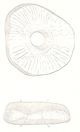
There is evidence of human activity in Belton from as far back as the Palaeolithic, the oldest archaeological find being a flint axehead from this period (NHER 10472). More flint tools appear in the record from the Neolithic, mainly consisting of axeheads (some of which are polished) and scrapers. A particularly fine example of this period is a hoard of polished and chipped axeheads, together with a polishing stone, that were found under a layer of peat in the early 1900s (NHER 10494). Evidence of activity continues with a quartzite macehead (NHER 10478) that could be late Neolithic or early Bronze Age.

A Neolithic or Bronze Age quartzite macehead from Belton. (©NCC)
Sites or finds relating to the Bronze Age were limited to this macehead and a few metal objects of slightly hazy provenance until advances in aerial photography revealed the cropmarks of several ring ditches. These are probably the ploughed-out remains of Bronze Age burial mounds. See, for example, ring ditches noted at NHER
17225.
There is little to be seen in the record from the Iron Age, the only finds being some fragments of pottery and a piece of worked bone (NHER 10488). However, aerial photographs show the cropmarks of enclosures and trackways which may possibly date to the period. Similarly, evidence of the Roman occupation is confined to pottery fragments, metal detected coins and a brooch.
The only finds from Saxon times are a spearhead (NHER 39867) found somewhere in the parish about forty years ago, a box mount (NHER 28449), a stirrup strap mount (NHER 41930), and, more interestingly, a Late Saxon (maybe Viking) gold ingot (NHER 33151).
After the Norman Conquest and moving into the medieval period, evidence of human activity and indeed settlement becomes more frequent. Metal detecting enthusiasts have recovered a wide range of medieval objects, including coins, buckles, harness pieces and a Papal Bull seal (NHER 15903). However, more tangible evidence of settlement comes in the form of All Saint’s Church (NHER 10502), a medieval parish church with later alterations. The south porch was added in the 15th century, and the whole building was restored in the 19th century, when the west tower was rebuilt. Inside, there is a 13th century font, and late 14th century wall paintings. There was a village in Browston in the medieval period (NHER 11433), but this has entirely vanished. It is thought to have stood near Browston Hall (NHER 24633).
Turning to the post medieval period, metal detecting has again recovered a wide range of objects, including coins (e.g. NHER 37367), spur fragments, buckles (e.g. NHER 25611), seals (NHER 39393) and a candle snuffer (NHER 20920). Of the buildings, probably the oldest to survive, although in a much altered state, are Thatched Cottage (NHER 34077) and Thatched Cottage on Church Street (NHER 40189), both of which date back to about 1600. Browston Hall (NHER 24633) was originally 17th century, rebuilt in the 18th century and altered in the 19th. The Manor house (NHER 24634) was originally an early 17th century farmhouse and barn, rebuilt in 1689, and now a single dwelling. The Old Hall (NHER 32582) is early 18th century.
The patchiness of some parts of the archaeological record does not necessarily indicate a lack of human activity, and may merely reflect a lack of detailed investigation.
Pieter Aldridge (NLA), 15 September 2005.
David Gurney (NLA), 5 April 2010.
Further Reading
Brown, P., 1984. The Domesday Book: Norfolk (Chichester, Phillimore)
Rye, J., 1991. A Popular Guide to Norfolk Place Names (Dereham, The Larks Press)