This Parish Summary is an overview of the large amount of information held for the parish, and only selected examples of sites and finds in each period are given. It has been beyond the scope of the project to carry out detailed research into the historical background, documents, maps or other sources, but we hope that the Parish Summaries will encourage users to refer to the detailed records, and to consult the bibliographical sources referred to below. Feedback and any corrections are welcomed by email to heritage@norfolk.gov.uk
Horsey is on the northeast coast of Norfolk in the North Norfolk district. Situated between Sea Palling and Winterton-on-Sea the parish has a very small population of around 100. The flat landscape is effectively drained and is protected by a series of sea defences. These were strengthened and rebuilt after being destroyed by floods in 1938. It took several years for the land to recover. The village name can be translated from Old English and means ‘island or dry ground in the marsh where horses are kept’. Land held in Horsey is recorded in the Domesday Book.
The earliest recorded archaeological objects are a number of Lower Palaeolithic flint handaxes (NHER 8399, 8400, 8401, 8402, 14871 and 22618) that have all been found on the beach. One of these was found after flooding in 1953 (NHER 8399). It seems likely that these flints are being eroded from peat deposits just off the coast. They are an important indication of early occupation of East Anglia. There is no other evidence for prehistoric activity. It is likely that the bleak and easily flooded landscape would not have been suitable for settlement.
There are few Roman records. A piece of Roman pottery and a coin (NHER 8403) were found southeast of the church and more pottery (NHER 8404) was found near Horsey Gap. It is suggested that two complete Roman querns (NHER 8405) may have been recovered but this is not completely clear. Old records provide the only evidence for Saxon finds. A possible Early Saxon sword and spears (NHER 28099) were found before 1843.
The round towered church of All Saints (NHER 8411) mostly dates to the 13th century but was extensively renovated and re-thatched in 1855. Inside there is an interesting 19th century stained glass memorial with a portrait of Miss Catherine Ursula Rising, a painter. The site of a medieval cross (NHER 13388) marking the boundary between Horsey, Waxham and Martham has now been lost. Peat and clay were heavily extracted from the landscape in the medieval period. The largest extraction pit filled with water and is now Horsey Mere (NHER 13507), a popular destination for holidaymakers. Other pits can be seen on aerial photographs (NHER 42154, 42156 and 42191). Sinuous medieval drainage ditches (NHER 42194) were dug to prevent the land becoming waterlogged. A piece of medieval pottery (NHER 8403) has been found near the church.

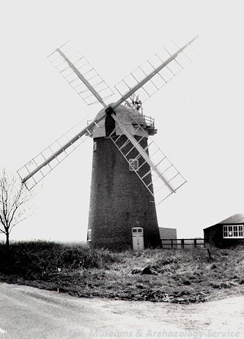
Horsey Mill was built in 1912 and is now owned by the National Trust. (© NCC.)
Post medieval drainage ditches (NHER
42144,
42145 and
42150) can be seen on aerial photographs. The land was drained by wind powered drainage pumps. The restored 20th century Horsey Mill (NHER
8408) is a five-storey brick tower mill owned by the National Trust and open to the public. It was built on the site of an earlier mill. There are wonderful views of the expansive landscape from the balcony at the top. The site of another wind pump (NHER
16355) is marked on an old map. The site of an old sluice (NHER
19707) is also recorded in this way. A number of wooden stakes may be the remains of this sluice. A canal (NHER
35366) was built from Horsey Mere to transport crops from local farms and later to serve a brickworks (NHER
35365) in Sea Palling. In addition to the extensive network of drainage channels two ponds (NHER
42192 and
42378) can be seen on aerial photographs. One of these has a small island in the middle of the pond (NHER
42378). This appears to have been designed to protect wildfowl from predators. A trackway (NHER
42208) not marked on any old maps but visible as a cropmark on aerial photographs probably dates to the post medieval period. Several buildings in the village are listed by English Heritage. This includes Street Farm barn (NHER
40557) that is dated to 1742, mid 18th century Kerrison House (NHER
43919) and Horsey Hall (NHER
43918) that was built in 1845.

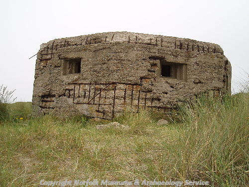
World War Two pillbox. (© NCC.)
The area was very important during World War Two and there are records of many buildings and monuments dating to this period. There were extensive beach defences including pillboxes (NHER
12843,
32646 and
32647), gun emplacements (NHER
42184 and
42094), beach scaffolding (NHER
42105) and other structures (NHER
42129 and
42130). Two possible minefields (NHER
42182 and
42102) were also part of this defence network. There was an extensive military site behind the dunes at Horsey Gap (NHER
42103). Possible bomb craters (NHER
42051,
42095 and
42369) can be seen on aerial photographs taken in the 1940s. It is unclear if Allied or German bombs created these craters. There is now very little left of these extensive sites. Most of the structures were dismantled after the war, the minefields were detonated or removed and the earthworks were levelled. Some beach scaffolding may remain buried on the beach and one pillbox (NHER
12843) can be seen in the dunes.
Megan Dennis (NLA), 24 March 2006.
Further Reading
Brown, P. (ed.), 1984. Domesday Book, 33 Norfolk, Part I and Part II (Chichester, Philimore)
Mills, A. D., 1998. Dictionary of English Place Names (Oxford, Oxford University Press)
National Trust, 2006. ‘National Trust Horsey Windpump’. Available:
http://www.nationaltrust.org.uk/main/w-vh/w-visits/w-findaplace/w-horseywindpump/. Accessed 23 March 2006.
Neville, J., 2004. ‘Norfolk Mills – Horsey drainage windmill’. Available:
http://www.horseyvillage.com/. Accessed: 23 March 2006.
Norfolk Federation of Women’s Institutes, 1990. The Norfolk Village Book (Newbury, Countryside Books and Norwich, Norfolk Federation of Women’s Institutes)
Rye, J., 2000. A Popular Guide to Norfolk Place-names (Dereham, The Larks Press)
Unknown, unknown. ‘HorseyVillage.com The Story of a Norfolk Village and its Inhabitants’. Available:
http://www.horseyvillage.com/. Accessed: 23 March 2006.