This Parish Summary is an overview of the large amount of information held for the parish, and only selected examples of sites and finds in each period are given. It has been beyond the scope of the project to carry out detailed research into the historical background, documents, maps or other sources, but we hope that the Parish Summaries will encourage users to refer to the detailed records, and to consult the bibliographical sources referred to below. Feedback and any corrections are welcomed by email to heritage@norfolk.gov.uk
Bunwell is located in south Norfolk, west of Forncett and northeast of New Buckenham. It is a linear settlement and is first mentioned in 1198. The village name is Old English, meaning ‘spring with reeds’, suggesting that it may have earlier origins although the settlement is not recorded in the Domesday Book. The name is apt as there is a spring just south of the main area of settlement. The parish includes not only the main settlement of Bunwell but several hamlets including Bunwell Bottom concentrated around Poppylots Farm (NHER 32853) and Bunwell Hill and Low Common. The parish has been extensively fieldwalked and metal detected and therefore much is known of the history of settlement in the area.

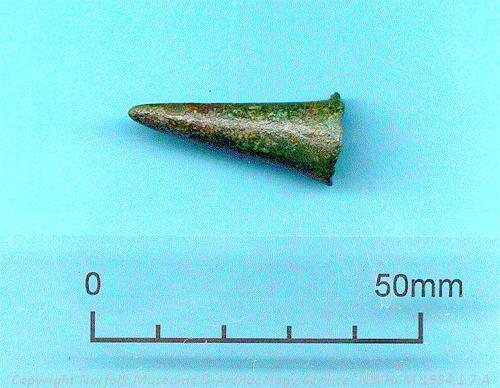
A Bronze Age ferrule from a hoard of objects found in Bunwell. NWHCM 1984.1.7:A (©NCC)
The earliest evidence for activity is a Palaeolithic handaxe (NHER 10033) that was recovered during fieldwalking. Several Mesolithic finds have also been made notably including a microlith (NHER 23091) and a handaxe (NHER
19509). Neolithic activity is represented by a polished axe (NHER
17244). The Bunwell Late Bronze Age hoard (NHER
17474) comprising eleven different items was probably buried by a metal worker in the 9th or 10th century BC. Several of the items in the hoard are unusual finds in Norfolk and the knife is unique. The axeheads, however, are not unusual – three other socketed axes have been found in the parish (NHER 10033 and 23091). An Early Bronze Age macehead has also been recovered from the area (NHER
24456). In addition to these objects fieldwalking has also recorded broad scatters of worked and burnt prehistoric flint (for example NHER
10005 and
16876) and some Iron Age pottery (NHER 23091 and
25181). Most of this prehistoric evidence is located near to the high ground of Bunwell Hill.

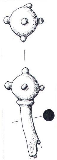
A Late Saxon pin from Bunwell. (©NCC)
Fieldwalking and metal detecting has also been useful in identifying scatters of Roman pottery and metalwork (NHER 9332 and 1005). This type of work led to the identification of a possible settlement site and subsequent excavation of two Roman pits (NHER 10007) belonging to a possible building. The recovery of forty-eight Roman coins from another site is also a probable indicator of settlement (NHER 24456). The building is located just southeast of the present village and it is possible that the centre of the village has slowly migrated northwest over time. A more unusual find was the possible Roman shackle (NHER 31504) found near to the ford.
The Roman settlement was also an area of Saxon occupation as shown by the excavation of a Saxon ditch and the finds of Saxon pottery (NHER 10007). Despite the general paucity of finds from Norfolk dating to the Saxon period the fieldwalking program in Bunwell has recovered unusually large numbers of scatters of Saxon pottery (NHER 18011, 23846, 25418) and metal finds including Early Saxon brooches (NHER 29454), a Late Saxon pin (NHER 9332) and a Late Saxon zoomorphic pendant (NHER 23989). A skeleton recovered during development of the bypass (NHER 10027) may date to the Saxon or medieval period.
Other medieval evidence suggests that the settlement pattern of modern Bunwell has medieval origins. Scatters of medieval pottery may indicate settlement, but are mostly spread by manuring of the fields (NHER 10012, 10013, 23417 and 29214). At least three medieval moats have been identified (NHER 10015, 10024 and 10034). Several medieval buildings still exist (NHER 10017, 10034, 10038, 24106 and 25291) and at least one other has been identified from the presence of medieval pottery and building materials collected during fieldwalking (NHER 17465). St Michael’s Church (NHER 10040) dates from the late 15th century and despite extensive renovations in the 19th century still retains many lovely Perpendicular features and an extremely wide nave.
The post medieval brickworks (NHER 16661) are now in ruins and the smock mill (NHER 15968) has been demolished but the more modern archaeology of Tibenham Airfield (NHER 23222) in the south of the parish which was used throughout World War Two can still be seen and is still in use as a glider airfield.
Megan Dennis (NLA), 13th September 2005.
Further Reading
Brown, P. (ed.), 1984. Domesday Book, 33 Norfolk, Part I and Part II (Chichester, Philimore)
Day, P., (1986), Archaeology of Bunwell, Unpublished document.
Mills, A.D., 1998. Dictionary of English Place Names (Oxford, Oxford University Press)
Rye, J., 2000. A Popular Guide to Norfolk Place-names (Dereham,The Larks Press)
Seaward, N., 2005. ‘Bunwell Community Website.’ Available:
http://www.bunwell.org.uk/index.htm. Accessed 5 January 2006.