This Parish Summary is an overview of the large amount of information held for the parish, and only selected examples of sites and finds in each period are given. It has been beyond the scope of the project to carry out detailed research into the historical background, documents, maps or other sources, but we hope that the Parish Summaries will encourage users to refer to the detailed records, and to consult the bibliographical sources referred to below. Feedback and any corrections are welcomed by email to heritage@norfolk.gov.uk
Gayton is a large parish in the west of the county. It lies on the boundary of two very different geological deposits; chalk to the east and gault clay to the west. Running west to east through the parish is a deposit of riverine gravels and loam. Where the chalk meets the gault are a number of springs. These geological deposits are important because they seem to have influenced the location of settlement in the parish since the Palaeolithic period. Although the archaeological records in the parish date back to the earliest prehistory, documentary evidence is more sparse. Both Gayton and Gayton Thorpe are mentioned in the Domesday Book, although Gayton Thorpe was only called Thorp. The history of this village is interesting as in 1316 it is recorded as being called Aylsweithorp. It must have acquired the Gayton prefix some time after this. The appearance of both villages in the Domesday Book suggests that they may have a Saxon origin and this is reinforced when we consider the derivation of their names. Gayton comes from Old English and may mean 'Gaega's enclosure' or 'farmstead where goats are kept'. If the modern settlement pattern was developed by the Saxon period where were people living before then? To answer this question we must look at the archaeological records.
The earliest finds from the parish are two Palaeolithic flint handaxes (NHER 3736 and 16121). Flint implements were used throughout the prehistoric period and many Neolithic axeheads have also been recovered (NHER 3746, 3735 and 3739). Unusually fragments of Neolithic pottery (NHER 2322) have also survived thousands of years and have been found in the parish. A complete Beaker period vessel (NHER 3738) with black deposits inside it has also been recorded. Metals were first used in the Bronze Age. Several Bronze Age copper alloy objects have been found. These include a rapier (NHER 3739), palstave (NHER 3741), spearhead (NHER 11346) and axehead (NHER 2144). The remains of many Bronze Age barrows have also been recorded from aerial photographs. Frequently these can be seen as ring ditches (NHER 11294, 11756 and 15401). As the land is ploughed the raised part of the barrow is flattened and all that is left is the ditch that surrounded it. One of these ring ditches was excavated in the 1930s (NHER 3778). In a few cases the barrow itself has also survived (NHER 3742). A complete, unploughed example in Gayton is known as the Hill of Peace. Interestingly these Bronze Age barrows and ring ditches are all located on the western edge of the chalk, on a slightly higher part of the landscape overlooking the lower gault clay.

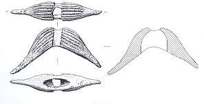
An Iron Age 'moustache' made of copper alloy. (© NCC.)
Iron Age objects have also been recovered. Metal detectorists have found an Iron Age terret (NHER
3739) and brooch (NHER
29713). On one site a collection of Iron Age objects including brooches, coins and a copper alloy 'moustache' (NHER
16121) were found. It is not clear what the moustache was used for! It may have been a toggle or fastening of some kind or a type of horse harness. Iron Age pottery (NHER
17752) and coins (NHER
31560 and
31620) have also been recovered at other sites. The coins (NHER
31620) from one of these sites are very unusual. They come all the way from Gaul (modern France). In contrast to the location of the Bronze Age barrows the prehistoric finds are found in the loam zone which stretches from the west to the east side of the parish.
There is plenty of evidence for activity in the Roman period. Gayton Thorpe Villa (NHER 3743), a two block winged building, was excavated in the 1920s. Further fieldwalking around the structure located the presence of a detached bath house and other structures. Other areas of settlement have also been identified. Eight concentrations of pottery and other finds (NHER 3592) suggests an area of intense activity with at least three buildings of brick. The other concentrations may represent timber buildings. A scatter of Roman pottery, coins, brooches and other metalwork (NHER 16121) are also indicative of Roman occupation. On the southwest parish border a third concentration of finds (NHER 30030), including a hoard of barbarous radiate coins and coin manufacturing debris, indicate a third area of settlement. In between these areas there is evidence for a possible Roman field system (NHER 11776). The settlements are likely to have been linked by a series of Roman roads (NHER 19913) or tracks. Some of the Roman finds from the parish are quite exotic. They include fragments of a Spanish globular amphora (NHER 16784), many brooches (NHER 3739, 17470 and 22092), a snake head bracelet (NHER 32823) and a pendant (NHER 29713).

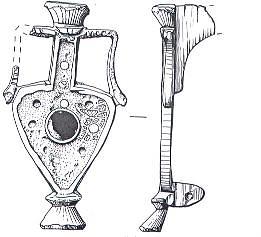
A Roman brooch in the shape of a flagon. (© NCC.)
One of the brooches is in the shape of a wine flagon (NHER
31560) and another is an important Colchester brooch that shows a transition between two types of brooch manufacture (NHER
33874). Roman coins (NHER
3744,
11294 and
14072) have been found across the area. One is a plated denarius (NHER
34436). The Roman finds are again concentrated on the loam or the edge of the chalk deposits, where the springs are. There is a clear concentration at Gayton Thorpe and an absence in the northeast of the parish on the chalk upland area.
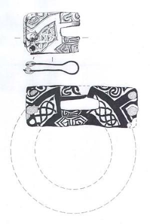
There is less evidence for Saxon activity. An Early Saxon cemetery on the parish border has been identified from a scatter of brooches and other personal adornments recovered by a metal detectorist. Human bone has also been recovered in the field. This suggests that this was an inhumation rather than a cremation cemetery. Many other single finds of Early Saxon brooches (NHER 33873, 29274 and 29713), two buckles (NHER 11294 and 29392), a pin (NHER 16121) and a staple (NHER 31812) have also been found. A relatively rare Middle Saxon caterpillar brooch (NHER 3739), a pin (NHER 29392) and a hooked tag (NHER 30034) have also been found. A very exciting and unusual Middle Saxon buckle plate (NHER 30881) has also been discovered. This was made from an 8th century gilt copper alloy mount that had been cut and bent forming a buckle plate with ornate decoration on each side.

A Middle Saxon buckle plate made out of an 8th century mount. (© NCC.)
Late Saxon objects such as box mounts (NHER
3739 and
29715), a penny of Eadgar (NHER
30037), a strap fitting (NHER
31836) and the arm of a pair of tweezers (NHER
29392) have also been found. In addition to these metal finds fragments of Late Saxon pottery (NHER
17749 and
23717) have been recovered, some from St Nicholas' churchyard (NHER
3770). The majority of these Saxon items come from Gayton village and they are the first evidence for settlement here. Parts of St Mary's Church, Gayton Thorpe (NHER
1044) date to the Saxo-Norman period. This archaeological evidence ties in well with the place name evidence that suggests a Saxon origin for the modern settlements.
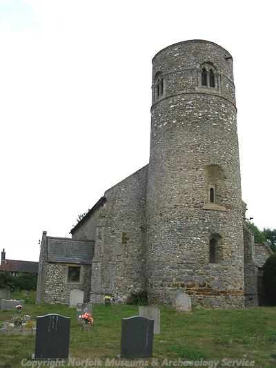
By the medieval period, as we have seen above, the modern settlement pattern of the villages was established. There is also evidence for occupation at other locations. The deserted medieval village of Wella (NHER 11830) has been identified. Other medieval sites can be seen as earthworks on aerial photographs (NHER 3748, 14071 and 30904). A medieval moat and associated fishponds (NHER 3771) have also been recorded. Between these scattered areas of occupation a system of fields (NHER 11776) would have been laid out. Some of the best preserved medieval archaeology is within the churches of the parish. St Mary's, Gayton Thorpe (NHER 1044), a round-towered church, was mostly built in the 14th and 15th centuries. St Nicholas', Gayton (NHER 3770) dates to the early 14th century, although the large amounts of reused stone used in its construction suggests there may have been an earlier church on the same site. At Well Hall (NHER 3593) another religious site is recorded. This is the Benedictine Cell of Stephen of Caen. Some of the earthworks around the hall may be related to this cell which was founded in 1081 and dissolved in 1415. A medieval stone cross (NHER 12438) is marked on maps but can no longer be seen. A large fragment of tracery, an ornate architectural stone openwork commonly used at the top of windows in churches, was hit by a plough in a field in the parish. It doesn't seem to come from either of the local churches and so how it got into the field remains a bit of a mystery. Although unusual the 15th century coin from Milan (NHER 30034) found by a metal detectorist in Gayton has been identified as a Billon Sestino of Filipo Maria Visconti, a Duke of Milan.

The Late Saxon or Norman round tower of St Mary's Church, Gayton Thorpe. (© NCC.)
The post medieval tower mill (NHER
5271) of Gayton is probably one of the most recognisable buildings in the village. Standing seven storeys tall and with an associated bakehouse and other buildings it was used to grind flour. The bakery ovens were also used by the villagers to bake their bread out of hours. It was built in 1824 to replace an earlier mill (NHER
15000) and was used until 1912. There may also have been a post medieval watermill (NHER
33873) near Well Hall but its exact location is unknown. Other post medieval buildings remain standing. Well Hall (NHER
3593) was built around 1700 and Gayton Hall (NHER
3771) a hundred years later. The lake at Gayton Hall was pumped by a post medieval hydraulic ram (NHER
3772). Parts of Gayton Workhouse built by Donthorne in 1836 still remain, although the majority has been demolished or significantly altered. It is now known as Eastgate House (NHER
3607). To the north of the village the ground gently rises and it is here that the remains of several post medieval limekilns (NHER
12552 and
12763) are located. Chalk was dug out here and then burnt to make lime. A post medieval brickworks (NHER
3749) has also been recorded.
Megan Dennis (NLA), 22 December 2005.
Further Reading
Brown, P. (ed.), 1984. Domesday Book, 33 Norfolk, Part I (Chichester, Phillimore)
Gregory, T., 1982. 'Romano-British Settlement in West Norfolk and on the Norfolk Fen Edge' in Miles, D. (ed.), 1982. The Romano-British Countryside. Studies in Rural Settlement and Economy. Part II. British Archaeological Reports. British Series. 103 (II) (Oxford, BAR)
Mills, A.D., 1998. Dictionary of English Place Names (Oxford, Oxford University Press)
Neville, J., 2004. 'Gayton tower windmill'. Available:
http://www.norfolkmills.co.uk/Windmills/gayton-towermill.html. Accessed: 22 December 2005.
Pevsner, N. and Wilson, B., 1999. Norfolk 2. North-west and south (London, Penguin Books)
Rye, J., 2000. A Popular Guide to Norfolk Place-names (Dereham, The Larks Press)