This Parish Summary is an overview of the large amount of information held for the parish, and only selected examples of sites and finds in each period are given. It has been beyond the scope of the project to carry out detailed research into the historical background, documents, maps or other sources, but we hope that the Parish Summaries will encourage users to refer to the detailed records, and to consult the bibliographical sources referred to below. Feedback and any corrections are welcomed by email to heritage@norfolk.gov.uk
Mundham is a small parish in the southeast of the county, close to the town of Loddon. The tiny hamlet of Mundham is now little more than a few houses and farms clustered around an area of former common land in the north of the parish. Mundham comes from the Old English meaning ‘homestead or enclosure of the man named Munda’.
The earliest archaeological artefacts from the parish are prehistoric flints (NHER 21523, 21525, 21876, 28342) and Neolithic flints (NHER 28508) collected over a number of years.
Iron Age coins (NHER 24894, 28342), including a gold coin (NHER 28508), a strap fitting (NHER 28342), a terret (NHER 29312) and fragments of pottery (NHER 29312) have been found during metal detecting. Roman pottery (NHER 21525), coins (NHER 21872, 28342, 28508, 30426), an amphora-shaped strap end (NHER 21872) and several brooches (NHER 24894, 28342, 29313) have been found in the parish.
Several archaeological evaluations have been carried out on a site off Mundham Road (NHER 29198) since 1992, revealing a long history of occupation dating back to the prehistoric period. Evidence of Neolithic activity has been recovered from the site in the form of worked flints and pottery, and a number of Early Neolithic pits have been discovered, including one that contained burnt wood and other debris, and a human cremation. Other pits have been dated to the Bronze Age, and a ditch and two pits have been dated to the Iron Age. This does not seem to have been the site of a Roman settlement, although Roman pottery has been found on the surface. A settlement was established here in the Early Saxon period, and the remains of sunken-featured buildings, or grubenhauser, have been excavated, as well as a Middle Saxon post-hole. Metal detecting on the site has recovered a Viking bridle cheekpiece and other metal finds. The latest archaeological features found on the site are two post medieval drainage ditches.
The site of an Early Saxon inhumation cemetery (NHER 21872) has been found during metal detecting, and a number of Early Saxon brooches and other metal finds have been recovered from the site. Other Saxon finds from the parish include an Early Saxon sword pommel (NHER 24894), Middle Saxon brooches (NHER 21872, 24894, 28508), a dress fitting (NHER 28342), pins (NHER 30426, 34959), a Middle to Late Saxon strap end (NHER 40684), Late Saxon mounts (NHER 21872, 30426), a pin (NHER 21877), a bridle cheek-piece (NHER 28342), pieces of pottery (NHER 28736), coins (NHER 28794, 29455) and brooches (NHER 29312, 33432) have been found during metal detecting. In the Domesday Book Mundham was divided between several landowners, and had a church, beehives and a fishery as well as meadow and woods.

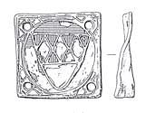
A square copper alloy medieval mount. Traces of red and blue enamel and gilded decoration remain. (© NCC)
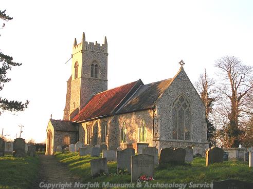
St Peter’s Church (NHER
10465) has a 12th century nave, a 14th century chancel and 19th century alterations. The church has an elaborately carved 12th century doorway with three different orders. The interior contains a medieval wall painting of St Christopher, a 12th century font that was restored in the 19th century, a 15th century rood screen and an original wafer oven in the tower. Only the ruined chancel of St Ethelbert’s Church (NHER
10459) is still standing, and the remains probably date from the 13th or 14th centuries. The church is recorded as having a Rector in 1305, but by 1593 it was served by a curate and the church was abandoned in 1749. Possible medieval house platforms (NHER
21869) are visible as earthworks in a field off Mundham Road close to the parish boundary with Loddon. The earthworks of two possible house platforms of unknown date (NHER
31948) are visible in fields close to Abbey Farm.

St Peter's Church, Mundham. (© NCC)
Hall Farm (NHER
34090) is a late 16th or early 17th century timber framed and thatched house with a later 18th century range and a 20th century pebbledash exterior. The nearby barn is also timber framed and dates to the early 17th century. Abbey Farmhouse (NHER
14053) is a 17th century timber framed and brick house, dated 1654, with a later 18th century range. The house has a large gabled dormer window with ovolo-moulding and an 18th century dairy to the south. White House Farm (NHER
34089) a 17th century timber framed and thatched house built on a lobby-entry plan. The house has an axial stack with polygonal shafts, and ovolo-moulded beams in the interior. Lower Barn (NHER
36111) is a mid 17th century brick stable with coped and pinnacled gables and an original mullioned window. This is a rare example of a purpose-built 17th century stable. Mundham Grange (NHER
44682) is a 17th and 18th century timber-framed and brick farmhouse surrounded by a moat. Mundham House (NHER
10467) is an 18th century brick house that was extended and altered in the 19th and 20th centuries. The house has sash windows, a central pedimented door and an elaborately tiled lavatory dating to about 1800. The stables also date to the 18th or early 19th century and have lunette windows. Elfreder Cottage (NHER
44680) and the nearby barn (NHER
44681) date to the late 18th or early 19th century and are built of clay lump with thatched roofs.
A smock mill (NHER 12276) is shown on Faden’s map of 1797 near the present Mill Farm. The mill was last used in 1916 and has now been demolished.
Sarah Spooner (NLA), 31 July 2006.
Further Reading
Brown, P. (ed.), 1984. Domesday Book: Norfolk (Chichester, Phillimore)
Mills, A. D., 1998. Dictionary of English Place-Names (Oxford, Oxford University Press)
Rye, J., 1991. A Popular Guide to Norfolk Place-names (Dereham, Larks Press)