This Parish Summary is an overview of the large amount of information held for the parish, and only selected examples of sites and finds in each period are given. It has been beyond the scope of the project to carry out detailed research into the historical background, documents, maps or other sources, but we hope that the Parish Summaries will encourage users to refer to the detailed records, and to consult the bibliographical sources referred to below. Feedback and any corrections are welcomed by email to heritage@norfolk.gov.uk
Barsham parish is located north of Fakenham and south of the pilgrimage centre of Little Walsingham in north Norfolk. The parish includes several small villages – Houghton St Giles, West Barsham, East Barsham and North Barsham. The name Barsham means ‘homestead or village of a man called Bar’. Bar may derive from boar and be a nickname. The Domesday survey identifies a man called Toki as owning land here prior to 1066. After 1087 Hugh owned the land. The parish is rich in archaeological finds from many periods, but contains some particularly splendid churches and monuments related to pilgrimage to nearby Little Walsingham.
The earliest evidence for activity in the parish is finds of burnt flints (NHER 33405) and prehistoric worked flints (NHER 1964). The earliest of these is a leaf arrowhead (NHER 35746) from the Early Neolithic period. Neolithic flint axeheads have also been found (NHER 1996, 2108 and 2109). The earliest monument in the parish is Norwich Long Lane (NHER 2134) that may be a prehistoric track.
The parish was also a through route for the Romans. A Roman road (NHER 1791) runs along the parish boundary to the west, and would have led to Brancaster on the north Norfolk coast. There is little other evidence for Roman activity however. A scatter of Roman pottery and coins (NHER 29796) was recovered very close to the parish boundary and this may indicate a small settlement along the line of the road.
In contrast the only evidence we have for Saxon activity is in the valley bottom close to the railway where digging to insert a sewer found some Early Saxon pottery (NHER 2045). The Late Saxon church (NHER 2111) of The Assumption in West Barsham incorporates some earlier Roman building material and some Norman features. The other churches within the parish all date to the medieval or post medieval periods.
The earliest medieval structure is the tiny, truncated 13th century All Saints’ church (NHER 12244) at North Barsham. This stands on a mound, perhaps suggesting this was the site of an earlier religious site, and is in Early English style. Although there are now only a few farm buildings around the church, earthworks of the deserted medieval village (NHER 11543) of North Barsham can be seen close to the river. East Barsham All Saints’ church (NHER 12243) also contains elements of 13th century building but continued to be rebuilt into the 15th century. Only the nave and porch tower now remain. The slipper chapel (NHER 2068) at Houghton St Giles was built between 1350 and 1380 and was designed for pilgrims to leave their shoes at on their way to Walsingham. It has been the National Shrine of Our Lady since 1934.

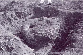
A medieval or post medieval well exposed during ploughing in Barsham. (©NCC)
Churches are not the only medieval archaeology in the parish. Wolterton Manor House, often called Barsham Hall, (NHER
2112) is a brick great house and freestanding gatehouse that was built in the Tudor period in 1520 to 1530 and still dominates the main road through East Barsham. Earthworks of a possible medieval moated manor (NHER
15476) to the south of Wolterton may represent an earlier manor building. A medieval or post medieval well (NHER
39751) was excavated after it was exposed during ploughing.
In the post medieval period grand houses continued to be built within the parish – at West Barsham a Jacobean hall (NHER 15381) stood on the site of Meadow House, and much of the building material from this hall was reused in the 19th century building that replaced it when the hall burnt down in 1815. Post medieval water meadows were identified at Houghton St Giles from aerial photographs. As industry grew in the parish lime and brick kilns were built (NHER 15829 and 15830) and the large pit where clay was extracted outside Houghton St Giles can still be seen. Houghton St Giles gets its name from the unusual church of St Giles (NHER 2064) that was designed by the architect William Nesbitt and built in 1879. The church reuses much of the building stone from an earlier church on the same site. The parish windmill (NHER 15200) is marked on old maps just to the north of Houghton, although the building no longer survives. More modern archaeological features include the Wymondham to Wells railway line (NHER 13588) that is now disused and a World War Two pillbox (NHER 19719).
Megan Dennis (NLA), 5th August 2005.
Further Reading
Brown, P. (ed.), 1984. Domesday Book, 33 Norfolk, Part I and Part II (Chichester: Philimore)
Knott, S., 2005. ‘Norfolk Churches All Saints North Barsham’. Available:
http://www.norfolkchurches.co.uk/northbarsham/northbarsham.htm. Accessed 27 January 2006.
Knott, S. 2005. ‘Norfolk Churches All Saints East Barsham’. Available:
http://www.norfolkchurches.co.uk/eastbarsham/eastbarsham.htm. Accessed 27 January 2006.
Knott, S., 2005. ‘Norfolk Churches Assumption West Barsham’. Available:
http://www.norfolkchurches.co.uk/westbarsham/westbarsham.htm. Accessed 26 January 2006.
Mills, A.D., 1998. Dictionary of English Place Names (Oxford: Oxford University Press)
Rye, J., 2000. A Popular Guide to Norfolk Place-names (Dereham:The Larks Press)