This Parish Summary is an overview of the large amount of information held for the parish, and only selected examples of sites and finds in each period are given. It has been beyond the scope of the project to carry out detailed research into the historical background, documents, maps or other sources, but we hope that the Parish Summaries will encourage users to refer to the detailed records, and to consult the bibliographical sources referred to below. Feedback and any corrections are welcomed by email to heritage@norfolk.gov.uk
The small parish of Mundesley is situated on the northeast coast of Norfolk, immediately north of Paston. Its name comes from the Old English for Mundel’s clearing. People have been living in the area for a long time, and the parish was certainly well established by the time of the Norman Conquest, its population, land ownership and productive resources being detailed in the Domesday Book of 1086.
The earliest evidence of human activity comes in the form of prehistoric but otherwise undateable flint tools, including an axe and flakes (NHER 6859, 6874 and 41583). A piece of carved Palaeolithic wood (NHER 6860) is reported to have been found at the foot of a cliff, and a Mesolithic flint pick (NHER 6861) was recovered from the beach in 1958. Neolithic finds include a chipped axehead (NHER 6864), also found on the beach, and an arrowhead (NHER 6862). Bronze Age objects consist of copper alloy axeheads (NHER 6866, 6867 and 6868) and a stone battleaxe (NHER 18374). There are currently no Iron Age finds, but aerial photography has tentatively identified traces of field systems (NHER 39059 and 38933) and ditches (NHER 39065) that may be of Iron Age or Roman date
A possible Roman road (NHER 41037) passed through the parish, running from Cawston to Mundesley via Bacton and linking with a known route to the coast. Roman finds consist of coins (NHER 6870, 6872, 23762 and 30901) and a copper alloy military camp-kettle (NHER 6869) that was found in gravel deposits before 1900. Nine Early Saxon cremation urns (NHER 6872) were found during building works in 1965, indicating a cemetery. Other Saxon finds are brooches (NHER 15974 and 21434) and an iron spearhead (NHER 16294).
The medieval period has left the parish with its oldest surviving building, All Saints’ Church (NHER 6884). This is a Norman, 14th and 15th century church, almost completely rebuilt between 1899 and 1914 after standing in ruins for a hundred years. Every remnant still in situ or discovered in the churchyard appears to have been re-used with imagination and affection. The building consists of a nave with a western extension, south porch and chancel, with a 20th century vestry to the north. The oldest original feature is a Norman slit window on the north side. Inside is a massive plain 14th century octagonal font, a nice Jacobean pulpit with a tester which originally came from Sprowston near Norwich, and the arms of Queen Victoria.
Medieval finds include fragments of pottery (NHER 6873, 12543 and 19221), coins (NHER 20918 and 30901), part of a pilgrim bottle (NHER 18891) and a lead crucifix (NHER 28516). A medieval or post medieval cannon (NHER 15350) was found on the beach at very low tide in 1979.
Of the post medieval buildings on the record, probably the earliest is Laurels Farm, Birchway (NHER 40725), a 17th century or earlier two storey rendered timber framed house, with 17th to 18th century brick gable ends, a rear service wing of 1732 and a 20th century porch. Mundesley House (NHER 14143) has a datestone of 1603 or 4 on its left hand gable wall, but appears to be early 19th century in date. The barn (NHER 14140) north of The Grange is a long thatched brick and flint building with an eroded date plaque that seems to read 1714.
The Dell (NHER 44613) at 14 Beach Road is a pair of early 19th century single storey Gothic style cottages, now one dwelling. A 20th century conservatory is now across the façade. Cowper House (NHER 44614) at 33 High Street is also early 19th century, two storeys high in rendered brick with a pantile roof. The façade has three window bays and a central doorway.
NHER 14141 is an early 19th century circular brick kiln, circular in plan with a conical tower. It has its original entrance and sunken entrance to the stoke hole. Windows were inserted in the 20th century and it is now used as an office.

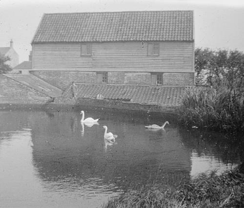
Mundesley mill pond. Courtesy of Norfolk County Council Library and Information Service.
Other post medieval buildings have not survived. At NHER
14144 is the site of a water mill. All that remains is the water wheel set in a flint mill race and where the mill was is now flower gardens. An early 19th century miller's house stands nearby. Another water mill (NHER
15431), marked on a late 18th century map, has disappeared entirely.
The Norfolk and Suffolk Joint Railway (NHER 13585) ran through the parish. This was a late 19th and early 20th century railway, from East Runton to North Walsham, via Cromer, Overstrand, Trimingham, Mundesley, Paston and Knapton. The Cromer to Mundesley section was closed in 1953, with the other sections closed in 1964. Part of the line is still active. Some parts of the line have been built over, while others sections are still used as roads and paths. Paston and Knapton stations and a number of bridges and embankments survive, as does a viaduct at East Runton.

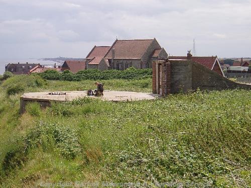
The remains of a World War Two coastal battery in Mundesley. (© NCC)
The landscape of the parish changed dramatically during World War Two with the construction of a huge network of anti-invasion structures along the Norfolk coast. These included pillboxes (NHER
18471,
18476,
39069 and
39146), tank traps (NHER
32620 and
32621), coastal defences (NHER
14142,
39147,
39148 and
39151), gun emplacements (NHER
39198) and slit trenches (NHER
39190,
39191 and
39192). The massive scale of these defences can be seen on contemporary aerial photographs, and although most of them were dismantled and cleared away after the war, some still exist today, like the Emergency Coastal battery (NHER
14142) and the pillboxes in the gardens of 20 Beckmeadow Way and 19 Marina Road (NHER
18471 and
18476).
To the west of the parish stands a Royal Observer Corps underground monitoring post (NHER 35420), opened in 1961 and closed in 1991. It was part of a network of such posts, designed to monitor fallout in the event of a nuclear attack.
Piet Aldridge (NLA), 31 October 2006.
Further Reading
Brown, P. (Ed.), 1984. Domesday Book: Norfolk (Chichester, Phillimore & Co)
Rye, J., 1991. A Popular Guide to Norfolk Place Names (Dereham, The Larks Press)