The Norfolk Historic Environment Record holds archives relating to many different aspects of Norfolk’s archaeology. This includes World War Two sites. We also have a library of RAF and a few Luftwaffe World War Two aerial photographs that help us record how the landscape was used in the past. The aerial photograph library is open to the public by appointment. The RAF photographs can be viewed online on E-map Explorer. Contact us using the links in the side bar to arrange a visit. The National Mapping Program has mapped many World War Two sites around the coast allowing us to identify coastal defences and other structures from old aerial photographs even if they are no longer extant. We have featured a number of records and photographs from our archive in this short article. The text and illustrations were originally used in a presentation during the Village at War weekend, 2006, at Gressenhall Farm and Workhouse.
During World War Two a series of defences were constructed across the country. A number of these still remain. The most well known are pillboxes. These were first built during World War One, but in World War Two an enormous construction programme took place. The NHER records both surviving pillboxes and the sites of pillboxes that have now been demolished. A few examples are examined here. For more details read Pillboxes in Norfolk.
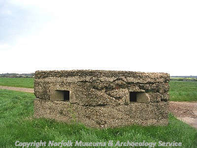
World War Two pillbox in Brisley. (© NCC)
Many different types of pillbox were built. A classic example can be seen at Brisley (NHER
5764). Some of the structures were camouflaged or made to look like normal buildings. A pillbox in Acle (NHER
14219) is disguised as a shed. Other buildings were also disguised in order to prevent them from being bombed or damaged. Happisburgh lighthouse (NHER
7192) was painted in camouflage colours during the war. Pillboxes were constructed to protect the coastline and major transport links. The example in Acle looks out over a road junction. A brick and concrete pillbox at Brancaster (NHER
15653) was built into the sea wall and was part of a larger range of defences around Brancaster Golf Club House. At Eccles-on-Sea a pillbox (NHER
32640) was built entirely into the sea wall.
On the coast pillboxes are often part of a much larger defensive system, as at Brancaster. There was a large military site at Horsey (NHER 42120) including several pillboxes, coastal defences, lines of barbed wire, anti-tank ditches, a minefield and huts and tents. The site stretched across the beach, dunes and over 300m inland into the marshes. Some pillboxes may appear to be separate from other defences but are actually linked (or were linked) by underground tunnels. The Royal Navy pillbox at Hunstanton (NHER 23514) is connected to the coastguard station next-door and a series of underground tunnels led to a nearby gun emplacement.
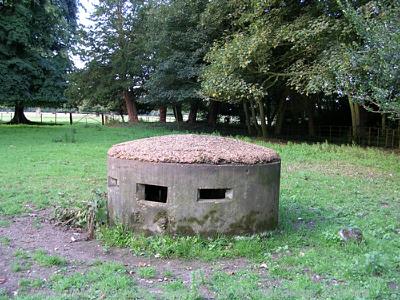
A rare example of a circular World War Two pillbox can be seen in Docking. (© NCC)
Most pillboxes are polygonal. A few examples are circular. A pillbox in Docking (NHER
30778) is a very rare example of a 'Norcon' circular pillbox. Another unusual pillbox from Norfolk is the heavy machine gun pillbox at Happisburgh (NHER
16971). It used to be surrounded by barbed wire obstructions.
Most of the pillboxes recorded on the NHER are in their original position or have been destroyed. On rare occasions pillboxes have moved! A pillbox on Happisburgh beach (NHER 15994) is actually upside down. It was originally located on the cliff top. It fell onto the beach between September 1965 and April 1968, presumably as a result of cliff erosion. A pillbox at Hunstanton (NHER 41426) has also probably slumped from its original position.
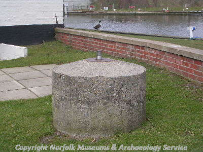
World War Two spigot mortar emplacement, Acle. (© NCC)
The remains of other defences can also be seen in Norfolk. Spigot mortar emplacements are relatively commonly recorded on the NHER. The spigot mortar at Acle (NHER
20595) has survived fairly intact. A large concrete post was constructed with a small steel pin placed on top of it. The gun was mounted on the pin. The soldiers stood in a trench dug around the post and so were protected from enemy fire whilst being able to rotate the gun to fire in almost any direction. The trenches around most spigot mortar emplacements have been filled in and often all that can be seen above ground is the steel pin and sometimes part of the concrete post.

A rare example of a World War Two Allan Williams Turret in Cley-next-the-Sea. (© NCC)
The Alan Williams turret is another kind of gun emplacement. It was designed to mount a Lewis gun to fire at aircraft or the enemy on the ground. The metal structure of these turrets rarely survives although there is one example at Cley-next-the-Sea (NHER
24183). They often get moved around away from their original locations as has happened at Cockley Cley (NHER
48902 to
48906). The turrets were mostly used to defend airfields or important structures.
During World War Two there was a whole series of defences around Norfolk’s coast. Parts of these remain although the sea has destroyed many. The coastal battery defences at Brancaster (NHER 31113) once consisted of two brick and concrete roofed gun houses connected by a semi-underground complex. This is the best-preserved battery in Norfolk but it has suffered considerably from coastal erosion. Another coastal battery defence at Cley-Next-the-Sea (NHER 24184) originally had two gun emplacements, a building and barbed wire obstructions. Now only parts of the gun emplacements remain. The emergency coastal battery defence at Mundesley (NHER 14142) would only have been used during an invasion. It consists of two gun emplacements that held ex-Naval 6-inch guns, semi-underground accommodation and a storage block. The guns were removed in late 1945 or early 1946 once the threat of invasion had passed.
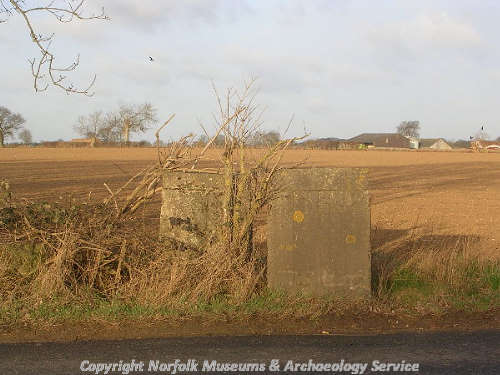
World War Two anti-tank cubes on Attlebridge Airfield. (© NCC)
If these coastal defences were breached there was a second line of defence. On many beaches and further inland a series of anti-tank cubes were erected. These were designed to stop tanks advancing any further. Some can still be seen at Hockering (NHER
40732). These were part of the defences of Attlebridge Airfield (NHER
3063). Anti-tank ditches (NHER
32505) were also dug, but these have been mostly filled in and can no longer be seen.
During World War Two many RAF and United States Army Air Force bases (NHER 2007) were constructed in Norfolk. Many of these can be seen on aerial photographs taken during the 1940s. After the announcement of the end of the war the RAF pilots had very little to do. The RAF decided to produce an aerial survey of the country. The photographs taken of Norfolk during this survey are now housed at Gressenhall in the Norfolk Aerial Photographs Library. RAF Horsham St Faith (NHER 8137) was photographed in 1946 as part of the national survey. The airfield is now Norwich International Airport.
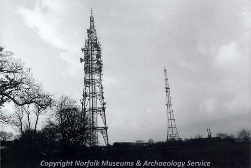
Two World War Two radar masts in Caistor St Edmund. (© NCC)
Suring World War Two a system of radar beacons was used to try and pick up signals from Germany and also for Allied communications. The radar beacons at Caistor St Edmund (NHER
14227) still survive. A plane hit one of the masts on 18th July 1942 killing the crew. There is a memorial to them at the base of one of the masts. The buildings and pylons at Bard Hill Radar Station, Salthouse (NHER
23386) were used during the war and then for some time afterwards. The complex took part in Project ‘Winkle’ in 1956 testing a passive radar detection system.
Enemy aircraft movements needed to be monitored during the war. The Royal Observation Corps manned a number of observation posts across the county. The concrete observation post at Beeston Regis Hill, Sheringham (NHER 21298) was linked to a large system of slit trenches. All that survives is the concrete base of the structure. A second example at Thornham (NHER 18077) consists of a small squat brick tower from which plane movements could be recorded. After the war these posts were gradually replaced with underground monitoring posts. These would have been used in the event of nuclear war. Each underground bunker was fitted with Geiger counters so that nuclear fall out radiation readings could be taken.
During World War Two the Luftwaffe (German Air Force) took a series of aerial photographs of the UK trying to locate potential bombing targets and obtain information. Many of the photographs are taken from very high and have obscuring cloud cover. Some details can be seen, however, and it is interesting to identify the subjects chosen for photography. Copies of a few of the photographs are held in the Norfolk Aerial Photograph Library. Norwich features often in the photographs. They may have been taken in order to select targets for bombing raids. The Luftwaffe also photographed Ketteringham Hall (NHER 9501) and surrounding woodland. The hall was used as a headquarters for the United States Army Air Force 2nd Division, which may explain why the hall was recorded.

A World War Two Nissen hut at the edge of Hockering Wood. (© NCC)
Ammunition needed to be stored somewhere safely during the war. Several ammunition depots were set up. Hockering Wood (NHER
38190) operated as RAF Hockering Forward Ammunition Depot. Ammunitions were stored here where enemy aircraft couldn’t see them. A network of concrete roads, buildings, bomb stores and water tanks survive within the wood. Bombs were stored within bays. Nissen huts were erected. These temporary structures were used extensively on military sites and many can still be seen in Norfolk, some converted into chicken sheds or farm buildings.
Norfolk is also the location of a unique World War Two military training camp. High Ash Training Camp, Ickburgh (NHER 34704) was used between January and May 1944 by the 7th Armoured Division (the 'Desert Rats'). It is the only British training ground to be used by this Division.
Perhaps some of the most important sites recorded on the NHER are the war memorials (NHER 26003). These are poignant reminders of the brutality of war. They permanently record the debt we owe to those who gave their lives for us. In a way the records for World War Two defences, camps and observation posts in the archive also act as a memorial. As more and more of these structures become forgotten, demolished or ruined the records held by the NHER remind people of their presence and importance. It is only by taking care of our local heritage that we can begin to understand how it is an important part of our history.
M. Dennis (NLA), 4 January 2006.