This Parish Summary is an overview of the large amount of information held for the parish, and only selected examples of sites and finds in each period are given. It has been beyond the scope of the project to carry out detailed research into the historical background, documents, maps or other sources, but we hope that the Parish Summaries will encourage users to refer to the detailed records, and to consult the bibliographical sources referred to below. Feedback and any corrections are welcomed by email to heritage@norfolk.gov.uk
Fordham is a long narrow parish located in west Norfolk. It lies to the south of Downham Market and is northeast of Littleport. The small village of Fordham is sited in the west of the parish, on some of the highest land in the vicinity and on the fen edge. The Fens are to the west of the village and fenland features include the Cut Off Channel, Fordham Fen and the confluence of the Rivers Wissey and Great Ouse. The A10 King’s Lynn to Ely road passes through the east of the parish, while the King’s Lynn to Ely road passes through the centre.
Little archaeological work has been carried out in Fordham. Most reported artefacts have been discovered by chance and there is only one recorded metal detecting and fieldwalking site. Only a few sites have been identified from aerial photographs and no formal excavations have taken place. Most of the recorded archaeology is located in the east close to the village, with only a few sites situated in the west. As a result, little is known about past settlement and patterns of activity. Having said this, a number of observations can be made.

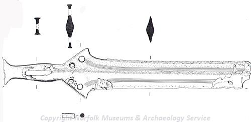
A decorated Bronze Age sword from Fordham. (© NCC.)
Three prehistoric artefacts have been found. A Neolithic or Bronze Age axe hammer (NHER
4443) and part of a decorated Bronze Age sword (NHER
24114) have been discovered close to the Cut Off Channel. Before 1906 a Bronze Age copper alloy socketed axehead was recovered, but exactly where it was found is uncertain.
Two Roman coins (NHER 29440) have been found close to the Cut Off Channel. In the northeast of the parish a number of undated enclosures (NHER 11774) are visible as cropmarks on aerial photographs. Two pieces of Roman pottery were found amongst them in 1978 during road construction works and these suggest that the enclosures could be Roman (although it is also possible that they could be earlier or later in date).
Two Early Saxon brooches, a Late Saxon strap end, a Late Saxon hooked tag (NHER 29440) and Late Saxon pottery have been found in the east of the parish, close to the village. In the Domesday Book of 1086 Fordham is recorded as ‘Forham’. This is an Old English placename meaning ‘homestead by the ford’. Also listed is the settlement of ‘Snora’. It is thought that this was located to the east of the village where Snore Hall (NHER 4463) now stands.
St Mary’s church (NHER 4469) is located in the village. Sections of the nave and chancel date to around 1400. In 1730 the tower collapsed and destroyed much of the building. The nave and chancel were subsequently repaired, but the tower, south aisle, vestry and a chancel chapel were demolished. In 1992 a medieval or post medieval well (NHER 28983) was found close to the church.
A medieval moat (NHER 4446) is marked on the 1st edition Ordnance Survey map to the southeast of the village. In 1960 medieval pottery and part of a post medieval plate were found on the site, but in 1966 the moat was destroyed. The earthworks of a possible medieval field system have been identified around the site of the moat, while cropmarks of medieval ridge and furrow (NHER 25380 and 25389) have been recorded to the north of the village.
Excavation work has suggested that there may have been a late medieval timber framed hall on the site of the present Snore Hall (NHER 4463). This building may have been demolished when the earliest part of the standing building was constructed in about 1520. This section was built as the north wing of a large and new great house; the rest of the early 16th century house was demolished in around 1580. A new northern section was added about 1700, with an eastern extension built in 1903. There is a 16th or early 17th century priest's hole and it is thought that Charles I used the building during the Civil War.
The fenland in the parish has been managed and drained since at least the medieval period. Evidence for this includes a silt ridge (NHER 24676) between Fordham and the River Wissey that may be an infilled medieval canal. Post medieval wind pumps and pumping stations are known to have been built at four sites. Three of these are located along the River Great Ouse (NHER 2506, 14504 and 14505), with the fourth between the River Wissey and the Cut Off Channel (NHER 4466).
High House Farmhouse (NHER 44141) was built around 1790 and Fordham House was built before 1880. There may have been a post medieval brickworks in Fordham village (NHER 30825). During World War Two a pillbox (NHER 2506) was built alongside the River Great Ouse close to the railway and a spigot mortar emplacement (NHER 16125) was constructed beside the River Wissey to the east of Hilgay Bridge. The pillbox has been demolished but the emplacement survives.
David Robertson (NLA), 1 December 2005.
Further Reading
Barringer, C., 1989. Faden’s Map of Norfolk (Dereham, Larks Press)
Brown, P. (ed.), 1984. Domesday Book: Norfolk (Chichester, Phillimore)
Mills, A.D., 1998. Dictionary of English Place-Names (Oxford, Oxford University Press)
Rye, J., 1991. A Popular Guide to Norfolk Place-names (Dereham, Larks Press)