This Parish Summary is an overview of the large amount of information held for the parish, and only selected examples of sites and finds in each period are given. It has been beyond the scope of the project to carry out detailed research into the historical background, documents, maps or other sources, but we hope that the Parish Summaries will encourage users to refer to the detailed records, and to consult the bibliographical sources referred to below. Feedback and any corrections are welcomed by email to heritage@norfolk.gov.uk
Burgh St Peter is a small and isolated parish on the county border with Suffolk, near Great Yarmouth. The name comes from the Old English, meaning ‘a fortified enclosure or stronghold’, or alternatively from the Old English meaning ‘a hill, or a mound’. The latter is perhaps more likely, given the location of the parish overlooking the flat marshes. Indeed, most of the land area of the parish is taken up by Burgh Marshes, whilst the settlement in the parish is scattered across the higher ground.
There is some evidence for early settlement in the parish, although it is very limited. A series of enclosures and pits are visible as cropmarks on aerial photographs, and prehistoric pottery and worked flint has been found (NHER 10745, 18349, 31317 and 35652), close to the edges of the marshes. The site of a ring ditch (NHER 16004), probably a Bronze Age burial mound, is also visible on aerial photographs.
Another area of cropmarks, on the high ground in the middle of the parish, is the remains of a Roman settlement (NHER 16005), which survives as a series of trackways and enclosures. A small number of Roman coins (NHER 10747, 32739 and 35229), other metalwork (NHER 35228) and pottery (NHER 16776 and 16777) have been found scattered throughout the parish.
There is little evidence for Saxon settlement in the parish, however the position of St Mary’s Church (NHER 10746) in Burgh St Peter is typical for an early church site; it sits on a promontory, overlooking the surrounding marshes. Close to the site of the church is a cropmark of a rectangular enclosure and several sunken features (NHER 36364), which may be the remains of Early Saxon grubenhauser, or sunken-featured buildings.

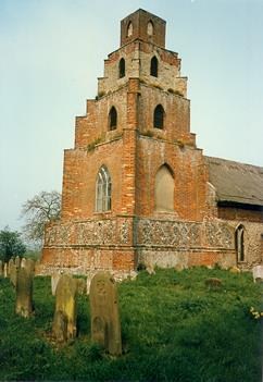
The unique tower of St Mary's Church, Burgh St Peter. Built on the base of an early 16th century tower the 18th century pyramidal construction most closely resembles a ziggurat. (©NCC)
Burgh St Peter is not mentioned in the Domesday Book, it first appears in 1254, when it was known as Wheatacre St Peter, and as Wheatacre Burgh in 1515. The village of Burgh St Peter itself is situated close to the parish boundary, and the modern settlement runs into Wheatacre, and the two may once have been part of the same landholding. Domesday Book lists a lost settlement close to the neighbouring parish of Aldeby, called Thurketeliart, which was listed as having a church, and it has been suggested that this entry may be for Burgh St Peter. However, Wheatacre is listed in Domesday Book as having two churches, and seems to have been a settlement well endowed with resources, such as pasture, woodland, and meadow, and it seems more likely that Burgh St Peter was included in the survey under Wheatacre, further evidence of the close historic connection between these two parishes.
St Mary’s Church (NHER 10746) is a famous local landmark, its unique and distinctive tower rises up above the marshes, transplanting the unsuspecting visitors from the Burgh marshes to the deserts of Mesopotamia. The present building dates back to the 12th century, with substantial alterations carried out in the 13th and 14th centuries. The site of a medieval chapel (NHER 10750) is close to St Mary’s Church (NHER 10746), and several medieval inhumations have been found (NHER 10748 and 10749).
During the post medieval period, the inhabitants of Burgh St Peter began to drain the marshes with more sophisticated technology, and several wind pumps and wind mills remain dotted through the modern landscape (NHER 15572, 37515 and 37516).
Sarah Spooner, 22 August 2005.
Further Reading
Brown, P. (ed.), 1984. Domesday Book: Norfolk (Chichester, Phillimore)
Mills, A.D., 1998. Dictionary of English Place-Names (Oxford, Oxford University Press)
Norfolk Federation of Women’s Institutes, 1990. The Norfolk Village Book (Newbury, Countryside Books)
Rye, J., 1991. A Popular Guide to Norfolk Place-names (Dereham, Larks Press)