This Parish Summary is an overview of the large amount of information held for the parish, and only selected examples of sites and finds in each period are given. It has been beyond the scope of the project to carry out detailed research into the historical background, documents, maps or other sources, but we hope that the Parish Summaries will encourage users to refer to the detailed records, and to consult the bibliographical sources referred to below. Feedback and any corrections are welcomed by email to heritage@norfolk.gov.uk.
Please note that this parish summary was compiled in 2006. In 2007, following publication of this article, the parish boundary between Hunstanton and Old Hunstanton was altered ensuring that the village now known as Old Hunstanton is located within Old Hunstanton parish. Many of the sites discussed within the article below are now located within Old Hunstanton parish.
The modern parish of Hunstanton is located on Norfolk’s northwest coast, about 19 kilometres north of King’s Lynn. It is a strip shaped parish and the beach forms its western boundary. Until the 19th century it was much larger and included the modern parish of Old Hunstanton. The two were divided when the town of New Hunstanton (now mostly known as Hunstanton) was established in the south as resort for the rich and famous. Confusingly the village called Hunstanton before the division is now known as Old Hunstanton. It is in the north of the parish and not in Old Hunstanton parish, although its medieval church (NHER 1136) is.
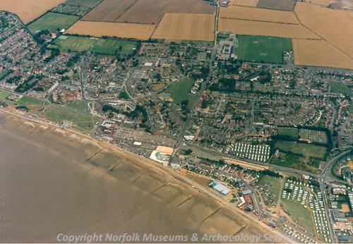
Hunstanton from the air. (© NCC.)
The archaeology of Hunstanton has been reasonably well studied and sites are recorded throughout the parish. There have been numerous stray finds, a few excavations have been conducted, and many sites have been identified on aerial photographs, including many recorded by the National Mapping Programme. Site visits have also been undertaken, a good number of historic buildings survive and some fieldwalking and metal detecting have taken place.
Prehistoric flint artefacts have been found at numerous locations. They include a Palaeolithic handaxe, at least one Palaeolithic flake, Mesolithic blades, burins, cores, scrapers and microliths, Neolithic axeheads, arrowheads, blades and cores and two Beaker barbed and tanged arrowheads. A Mesolithic stone macehead (NHER 13325) in Birmingham Museum may have come from the parish, although it could have been found in Heacham instead.
Excavations at Redgate Hill in the south during the 1970s and in 2001 revealed numerous prehistoric features. They included Late Neolithic/Bronze Age pits and round houses, Neolithic to Iron Age structures and a Neolithic to Iron Age palisaded enclosure (NHER 1396). Artefacts collected include Mesolithic, Neolithic and Bronze Age flint artefacts and Late Neolithic, Bronze Age and possible Iron Age pottery. On the eastern edge of the town a ring ditch (NHER 26942), possibly the remains of a Bronze Age barrow, is visible on aerial photographs. The name 'Ringlehowe' appears to the south of Old Hunstanton on a 17th century map. It suggests that there may once have been a Bronze Age round barrow on the site (NHER 1258). Nearby two pits containing Bronze Age pottery have been observed in a cliff face.
In 1974 a hoard of Middle Bronze Age copper alloy objects (NHER 1101) was found northeast of the town. It included a palstave, a torc, a neck ring, a pin and a bracelet. Other Bronze Age artefacts include a piece of 'ring money' (probably a personal ornament), axeheads and a miniature urn. Iron Age pottery has been collected at a number of sites between the town and Old Hunstanton village.
Roman pottery and coins have been discovered throughout. A rectangular enclosure (NHER 27157) visible on aerial photographs near Old Hunstanton village may have been a farmstead or settlement. Building material, a coin and pottery (NHER 1275) have been collected from a site and in 1953 Roman buildings and pits were discovered within the enclosure. There are also reports of a tessellated floor having been uncovered. In 1965 a building with a tile floor and an enclosing wall, pottery, roof tiles and a millstone (NHER 1271) were revealed close by. A gravel bank or road may have led to the building. In 1879, during the construction of a new esplanade and swimming baths in the town, three Roman pits (NHER 1267) were found. They contained oyster shells and pottery and were probably rubbish pits, although they may have been graves. Other features containing Roman pottery have been recorded after having fallen from the cliff face. Some of these have been described as 'tombs'.
An Early Saxon brooch, fragments of Middle Saxon pottery, a Middle Saxon bead and a Middle Saxon coin (NHER 1271, 1275, 1287, 11227, 11302 and 12841) have been discovered in the area around the Roman buildings. These suggest that the area continued to be used in the Saxon period, probably for settlement. In 1862 and 1897 human burials were uncovered in a gravel pit in the south of the town. At the time of their discoveries they were thought to be Palaeolithic, but radiocarbon dating has shown one to be Middle Saxon.
The modern parishes of Hunstanton and Old Hunstanton are combined as ‘Hunestanestuna’ in the Domesday Book of 1086. This is an Old English name meaning ‘Hunstan’s enclosure or farmstead’. The land in the parish was held by various people, including King William I, the Bishop of Thetford, John, nephew of Waleran. Freemen, villagers, smallholders, slaves, ploughs, meadow, woodland, cattle, pigs, sheep, mills, fisheries, beehives and a church were recorded. The church probably stood on the site of St Mary’s, Old Hunstanton (NHER 1136).
The earthworks of a medieval moated site (NHER 1277) survive to the east of Old Hunstanton village. Immediately adjacent are the cropmarks of probable medieval and post medieval field boundaries, drainage features and ridge and furrow (NHER 28502 and 26865). Further east the foundations of a medieval stone building (NHER 12841) have been discovered, as has a possible second moated site (NHER 11303). Concentrations of medieval and post medieval building material (NHER 1287), indicating the presence of buildings, have been identified in Old Hunstanton village.
The ruins of the medieval chapel of St Edmund. (© NCC.)
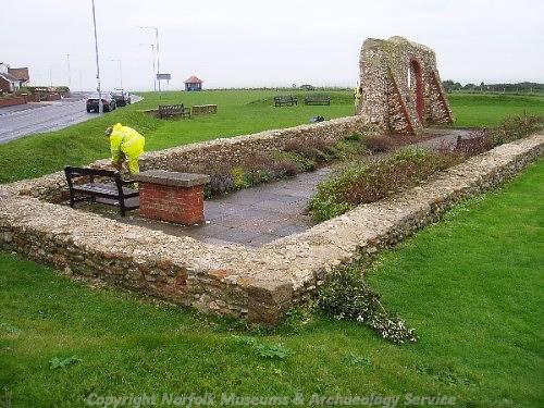
Features visible on aerial photographs and on historic maps suggest that the area to the west and southwest of Old Hunstanton village and that of the modern town were used for agricultural purposes during the medieval and post medieval periods. They include field boundary banks and ditches, some of which indicate the presence of strip fields, and possible roads. St Edmund's chapel (NHER 1291) stood amongst the fields, the ruins of which survive. Some sections date to the medieval period, although significant rebuilding took place during the laying out of a World War One memorial garden in 1915. Excavations were carried out in 1913 and fragments of 15th century window glass and 15th to 16th century glazed floor tiles were recovered.
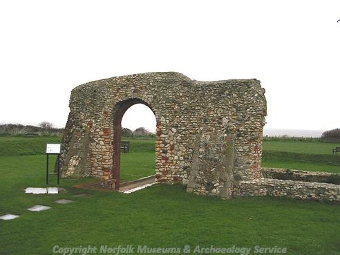
St Edmund's Chapel, Hunstanton. (© NCC.)
Many historic buildings survive in Old Hunstanton village. They include buildings at Cliff Farm, Lodge Hotel, Caley Hall, several houses on Old Hunstanton Road, cottages on Sea Lane, the Le Strange Arms Hotel and a courtyard of early 19th century coastguard cottages. The farmhouse at Cliff Farm (NHER 17151) dates from the 16th century and has an associated 17th to 18th century barn, an 18th century stable and 19th century cart sheds. It has been suggested that Lodge Hotel dates to the 16th century, although there is no external evidence for this. The exterior of the building is mostly 17th and/or 18th century in date, with a number of 19th century additions.
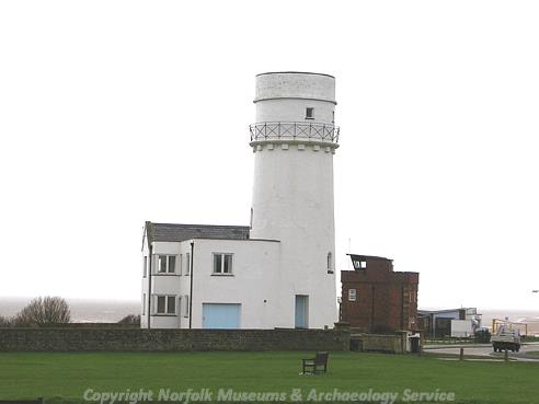
Hunstanton lighthouse. (© NCC.)
To the east of the village is an area that was called 'Bricklin' on a map of 1765. In 1970 waste fragments from a post medieval brick kiln (NHER 1281), including green glazed bricks, were gathered from the surface of a field. An area of reddish soil (NHER 26726) visible on aerial photographs could be this kiln or the site of a second. It is interesting to note that post medieval green glazed bricks have been found in a wall close by (NHER 11226). Hunstanton Lighthouse (NHER 1290) stands on the cliff top between Old Hunstanton village and the town. It was built during the first half of the 19th century, closed in 1921 and is now used as a private residence. It superseded a wooden structure that was constructed in the late 18th century, which itself had succeeded a lighthouse built around 1665.
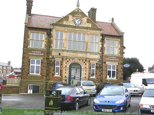
Hunstanton Town Hall. (© NCC.)
Henry Styleman Le Strange established the resort town of New Hunstanton in the mid 19th century and intended it to be a fashionable and picturesque centre for leisure and seawater bathing. Many 19th century resort buildings survive, including St Edmund’s Church (NHER 1292), The Golden Lion Hotel and the Town Hall. Surviving open spaces include Boston Square, Lincoln Square and part of the gardens Glebe House. In 1862 the town was connected to King’s Lynn by railway (NHER 13591), a link that helped to stimulate its growth. A 19th century water tower (NHER 40217) built on the eastern edge of the town has been demolished, although the Redgate water tower of around 1900 still stands in the south.
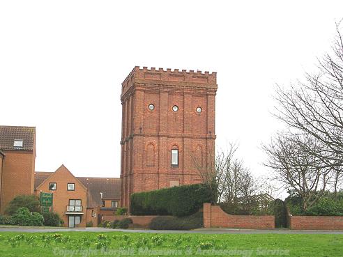
Redgate Water Tower, Hunstanton. (© NCC.)
During World War Two the parish was heavily defended. In June 1940 a coastal battery (NHER 26938) was built on the cliff top between the town and village. It included a minefield, an enclosure of barbed wire, Nissen huts, linear earthworks, ditches, gun emplacements and pillboxes, one of which was built to a Royal Navy design (NHER 23514). A pre-War coastguard tower was adapted for military use and returned to the coastguard at the end of hostilities. From 1934 the lighthouse (NHER 1290) was used by the Royal Observer Corps. This use this continued throughout the war and on until 1957. That year an observation post was constructed alongside the lighthouse and this functioned until 1968.
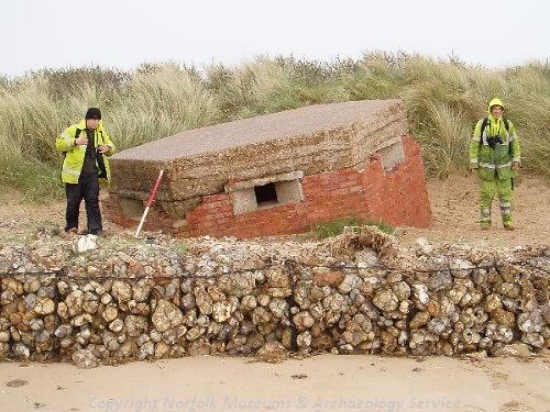
A World War Two pillbox that has probably moved from its original position. (© NCC.)
In the event of an invasion during World War Two, defences on the beach, on the cliffs and in the sand dunes would have served as the first line of defence. Barbed wire obstructions and anti tank scaffolding (NHER 26685 and 26694) were set up on the beach, with at least one pillbox (see NHER 41426) and a gun emplacement amongst them. At Old Hunstanton village, pillboxes, minefields, banks and slit trenches were constructed behind these amongst the dunes. Further back a substantial anti tank bank (NHER 26707) was built and anti tank cubes were used to block the road through the village and the A149. Slit and/or practice trenches were also dotted around the town.
On the beach close to the base of the cliffs is the wreck of the Sheraton, a trawler launched in 1907. Between 1915 and 1918 it was used during boom defence work and in World War Two it served as a patrol vessel. In 1945 it became a target ship, before being wrecked in 1947.
David Robertson (NLA), 15 May 2006.
Further Reading
Anonymous, no date. 'Hunstanton, Norfolk'. Available http://www.hunstanton.net. Accessed 15 May 2006.
Ashwin, T. & Davison, A., 2005. An Historical Atlas of Norfolk (Chichester, Phillimore)
Barringer, C., 1989. Faden’s Map of Norfolk (Dereham, Larks Press)
Brown, P. (ed.), 1984. Domesday Book: Norfolk (Chichester, Phillimore)
Knott, S., 2005. 'Chapel of St Edmund, Hunstanton'. Available: http://www.norfolkchurches.co.uk/hunstantonchapel/hunstantonchapel.htm. Accessed: 15 May 2006.
Mills, A. D., 1998. Dictionary of English Place-Names (Oxford, Oxford University Press)
Rye, J., 1991. A Popular Guide to Norfolk Place-names (Dereham, Larks Press)