This Parish Summary is an overview of the large amount of information held for the parish, and only selected examples of sites and finds in each period are given. It has been beyond the scope of the project to carry out detailed research into the historical background, documents, maps or other sources, but we hope that the Parish Summaries will encourage users to refer to the detailed records, and to consult the bibliographical sources referred to below. Feedback and any corrections are welcomed by email to heritage@norfolk.gov.uk
Emneth is a fenland parish on the border with Cambridgeshire in the southwest of Norfolk. The parish is south of Walsoken and north of Outwell. The modern villages of Emneth, Emneth Hungate and Holly End all lie within its boundaries. The name Emneth is Old English and its meaning has been debated. It may mean ‘smooth meadow’, ‘junction of streams on the River Aemenan’, ‘river confluence belonging to Eana’ or ‘mowing grass meadow’. The ‘Hungate’ suffix suggests this area may have been associated with the keeping or rearing of hounds. Whatever the meaning of the name it is clear that it comes from Old English and therefore probably has Saxon origins. It is therefore unusual that the village is not mentioned in the Domesday Book. This may be because the village was valued with another parish and not named. It does not necessarily mean the village didn’t exist. There is evidence for activity in the parish from the Roman period and metal detectorists have found many medieval and post medieval finds.
No prehistoric objects have been found here. This is unusual and may be because of the low-lying nature of the surrounding landscape. The Fens were not drained until the Roman period, and were a marginal area where people may have come frequently to hunt wild fowl or collect reeds, but were unlikely to have lived. The absence of finds does not mean that the landscape was not utilised, but rather that the evidence has not yet been found and that activity was likely to be seasonal or temporary and therefore the evidence for it is less likely to survive and is harder to find.
In the Roman period the fens were drained and we start to see more archaeological evidence for human activity. Roman coins (NHER 2383, 19513 and 22564) and Roman pottery (NHER 2384, 19632 and 22475) have been found. At one site a scatter of Roman finds (NHER 22468) including oyster shell, Roman pottery and personal ornaments may suggest an area of concentrated activity. An excavation has also identified Roman features (NHER 31127) but it is not clear if they are related to occupation or more temporary use. Interestingly part of the head of a Roman figurine (NHER 31622) has also been recovered. This is only the top part of the head, so it is hard to identify, but it may be part of a small statue of a Roman god. A Roman coin minted in Greece (NHER 31622) found at the same site is also unusual.

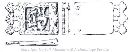
An Early Saxon square headed brooch from Emneth. (© NCC.)
In the Saxon period the earliest evidence for activity is three Early Saxon brooches (NHER
22468,
28959 and
32353) found by metal detectorists and one fragment of Early Saxon pottery (NHER
31818). Two Middle Saxon strap ends (NHER
2384 and
39619), one decorated with the head of an animal, and a Middle Saxon pin (NHER
25468) have also been found. Late Saxon pottery (NHER
19631), a Late Saxon or medieval ring (NHER
19513) and a possible Late Saxon lead spindle whorl (NHER
30876) decorated with stars have also been recovered. There was clearly activity in the area in the Saxon period, despite the lack of documentary evidence.

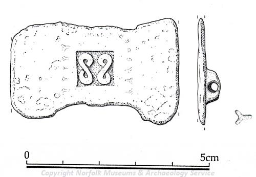
A medieval strap end from Emneth with the initials S and J. (© NCC.)
The earliest mention of Emneth in documents was in 1170. It is clear, therefore, that the village was settled by this date. St Edmund’s Church (NHER
2386) was built in the 12th century and extended dramatically in the 13th century. It remains a large and imposing building. Other medieval structures have been demolished. Hagbeach Hall (NHER
2384), a medieval hall, was demolished in 1887, although its 17th century stables remain and have been converted into houses. The medieval hall on the site of 17th century Oxburgh Hall (NHER
16726) was also demolished when the new hall was built. Other buildings have disappeared. A parochial chapel (NHER
14424) at Berking, Emneth was recorded in a document in 1389 but its location has since been lost. Other sites have lost their names and sense of importance – a medieval moated site (NHER
19631) has been recorded and a seal used by Pope Innocent III to secure documents was found here. This, and other finds including medieval seals matrices, a horse harness pendant and medieval coins suggests the site was of some importance. Domestic sites with less status have also been identified. Medieval hearths (NHER
24832), probably related to occupation, were excavated at Bird’s Corner and metal detecting has uncovered many medieval finds including pottery, coins and personal objects (NHER
39308) on one site. These include a spectacular strap end with the initials S and J (NHER
39308). The number of items recovered at this site suggests that this was an area of medieval settlement.
There are several records dating from the post medieval period. Two post medieval dovecots (NHER 2385 and 22166) are still standing, although the roof has fallen in on one of them. Banyers Hall (NHER 22168) is a mid 17th century building which originally had a service wing. Newfields Farmhouse (NHER 22167) was built in the 16th century and has since been split into two houses. Both structures are still standing. The site of a post medieval wind pump (NHER 16320) is recorded on a 19th century map. Other sites can be identified by local names. Tile Kiln Bridge is near a site where an area of burnt brick has been discovered. This suggests this might be the site of a possible medieval tile kiln (NHER 16615).
The archaeological evidence shows that there was human activity in the area from the Roman period onwards. The lack of prehistoric evidence is unusual but is probably explained by the waterlogged nature of the landscape until the Romans drained it. Most evidence for settlement comes from the medieval and post medieval periods.
Megan Dennis (NLA), 15th November 2005.
Further Reading
Brown, C., 2002. ‘Roll of Honour – Norfolk, Emneth, Norfolk’. Available:
http://www.roll-of-honour.com/Norfolk/EmnethMemorial.html. Accessed: 17 February 2006.
Brown, P. (ed.), 1984. Domesday Book, 33 Norfolk, Part I and Part II (Chichester, Philimore)
Knott, S., 2005. ‘St Edmund Emneth’. Available:
http://www.norfolkchurches.co.uk/emneth/emneth.htm. Accessed: 17 February 2006.
Mills, A.D., 1998. Dictionary of English Place Names (Oxford, Oxford University Press)
Rye, J., 2000. A Popular Guide to Norfolk Place-names (Dereham, The Larks Press)