This Parish Summary is an overview of the large amount of information held for the parish, and only selected examples of sites and finds in each period are given. It has been beyond the scope of the project to carry out detailed research into the historical background, documents, maps or other sources, but we hope that the Parish Summaries will encourage users to refer to the detailed records, and to consult the bibliographical sources referred to below. Feedback and any corrections are welcomed by email to heritage@norfolk.gov.uk
Old Catton is just north of Norwich now effectively joined to the city by the growth of suburbia around it. It is squeezed between the city parishes of Catton and Sprowston and is part of the Broadland district. The settlement has only recently been joined to the city and has Saxon origins – it is recorded in the Domesday Book and its name derives from the old English for ‘farmstead of Catta or Kati’. Catta or Kati may be a nickname because directly translated it means wildcat. At least some of the parish still retains open space – Old Catton Hall and Park are in the south of the parish whilst the north part is still under agriculture. Nevertheless the archaeological record is mostly made up of casual finds in people’s gardens and historical buildings rather than large-scale monuments identified from aerial photographs or extensive fieldwalking and metal detecting.
The earliest evidence of human activity is casual finds of prehistoric flints. The earliest of these is a Palaeolithic axehead (NHER 17946). There appears to be a dense scatter of Neolithic flint at the south end of Spixworth Road where several Neolithic worked flints (NHER 13421, 15033 and 20733) have been found in gardens including a fine translucent flint leaf arrowhead (NHER 20732). Nearby by in Catton Park a Neolithic or Bronze Age awl (NHER 33113) was discovered and a Bronze Age urn (NHER 8119) was dug up in the 1920s. Iron Age pottery (NHER 16758) has also been found in the park. Similar types of Roman finds have been made – metal detecting has recovered a Roman coin (NHER 24898), a small scatter of Roman metal objects (NHER 28861) and a Roman cosmetic mortar (NHER 41110). Roman pottery (NHER 11796) has also been found. None of these scatters are large enough to suggest occupation anywhere in the parish although there was Roman activity in the area.
A similar story can be told with the Saxon finds. An Early Saxon buckle (NHER 28861) and a Late Saxon hooked tag (NHER 41110) and Late Saxon strap fitting (NHER 24898) demonstrate activity in the area over this period but no sites can be identified. A lead model of a Late Saxon box mount (NHER 29738) suggests metalworking may have been going on nearby. It isn’t until the medieval period that we can begin to identify sites and buildings. The parish church of St Margaret’s (NHER 8132) has a Late Saxon or Norman round tower and there are several other Norman features. The remainder of the building was constructed in the 14th and 15th centuries. Nearby Manor House (NHER 8130) is a 16th century building but probably stands on the site of an earlier medieval manor or grange. The clay pits (NHER 8122) to the east of the church started to fill up in this period. The scatters of medieval pottery (NHER 11796, 16758 and 20733) found in gardens across the parish suggest that much of the land was under agriculture at this time. The pottery got spread around as the land was manured.

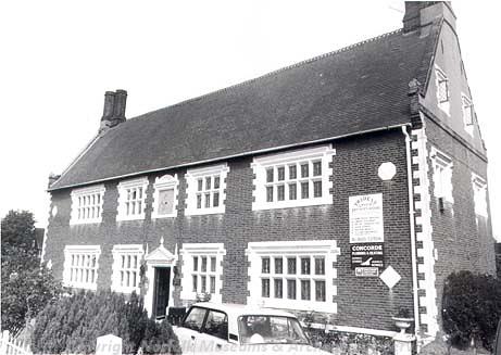
The Old Hall, Old Catton, a house that was built in 1632. (© NCC)
There are many building surviving from the post medieval period including Catton Hall (NHER
8131) and its landscaped park (NHER
30435). Old Hall (NHER
8129), Manor House (NHER
8130) and the Orangery (NHER
12515) that is now used as the village hall all have post medieval origins. Again a small scatter of post medieval finds (NHER
11796,
16758,
20733 and
31994) from surrounding gardens suggests the settlement around the church was still relatively small.
Several World War Two archaeological features can be identified that were part of Norwich’s defence system. In Catton Park an anti-glider trench was dug (NHER 40841) and a spigot mortar base and associated tank trap (NHER 32541) and an anti-aircraft battery (NHER 16715) were set up nearby. Two World War Two aircraft crash sites (NHER 40842 and NHER 40843) have been recorded on the northern edge of Catton Park.
Megan Dennis (NLA), 14th September 2005.
Further Reading
Brown, P. (ed.), 1984. Domesday Book, 33 Norfolk, Part I and Part II (Chichester, Philimore)
Mills, A. D., 1998. Dictionary of English Place Names (Oxford, Oxford University Press)
Rye, J., 2000. A Popular Guide to Norfolk Place-names (Dereham, The Larks Press)
Unknown, unknown. ‘Old Catton, Norwich, Norfolk, UK – community and parish website’. Available:
http://www.oldcatton.com/. Accessed: 8 February 2006.