This Parish Summary is an overview of the large amount of information held for the parish, and only selected examples of sites and finds in each period are given. It has been beyond the scope of the project to carry out detailed research into the historical background, documents, maps or other sources, but we hope that the Parish Summaries will encourage users to refer to the detailed records, and to consult the bibliographical sources referred to below. Feedback and any corrections are welcomed by email to heritage@norfolk.gov.uk
Burnham Norton, which comes from the Old English meaning ‘village on a stream’ and ‘north farm’, is one of the group of parishes that make up the Burnhams. The landscape of the parish is dominated by large expanses of salt marsh and beach, and the hamlet of Burnham Norton itself consists of only a few houses.
Several prehistoric flint implements have been found in the parish, including a Neolithic axehead (NHER 19676), a Neolithic or Bronze Age scraper (NHER 1756), and Bronze Age pottery (NHER 34280). The cropmarks of possible ring ditches (NHER 27046) are visible on aerial photographs, but the features may not be archaeological in origin.
Iron Age pottery (NHER 1737, 25918) has been found in the parish, and a square enclosure (NHER 27041), visible on aerial photographs, may date from the Iron Age or the Roman period. The cropmarks of a small farmstead (NHER 27060), which may date to either the Iron Age or the Early Saxon period, with a network of small fields and paddocks, have also been identified from the air. Roman pottery (NHER 1737, 25425) and coins (NHER 13660, 25918) have been found in the parish, and the site of a small Roman building (NHER 20343) has been identified from finds scatters. The cropmarks of a possible Roman field system (NHER 27010) are also visible on aerial photographs.
The parish is one of a group of parishes, created out of a larger Saxon estate. Some of the Burnham parishes were subsumed into the larger parishes. Indeed, in the Domesday Book Burnham Norton is indistinguishable from other settlements also called Burnham. St Margaret’s Church (NHER 1770) has a Late Saxon round tower as is situated on a hill overlooking the town of Burnham Market. Early Saxon brooches (NHER 1736, 25918, 29185 and 20343), Middle Saxon pottery (NHER 1737), and Late Saxon metalwork including coins (NHER 25918) and a gold finger ring (NHER 29185) have been recovered whilst metal detecting in the south of the parish, close to the important Middle and Late Saxon settlement and market (NHER 18496) in Burnham Market.

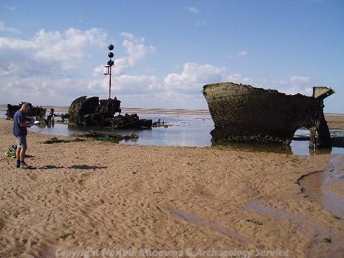
The wreck of the 'Vena' in Burnham Norton was used for target practice during World War Two. (©NCC)
The site of the medieval St Mary’s Friary (NHER
1738), the first Carmelite friary to be founded in Norfolk, is in the south of the parish. Although only the gatehouse is standing, the other buildings of the friary complex are visible on the ground as earthworks.
During the post medieval period, the inhabitants of Burnham Norton attempted to drain and reclaim some of the landscape close to the coast, which provided valuable grazing land. A number of post medieval drainage ditches (NHER 27034, 27039, 26663) are visible on aerial photographs, as well as the remains of industries that were carried out in the parish during the post medieval period. The earthworks of a late medieval or post medieval salt producing site (NHER 26661), oyster beds (NHER 26659, 26660) show that Burnham Norton thrived on the natural resources of the coastline.
The threat of invasion during World War Two also left its mark on the coastline. Anti tank cubes (NHER 18223), roadblocks (NHER 27028) and various military buildings (NHER 26668, 41464) are all visible on aerial photographs. The wreck of the ‘Vena’ (NHER 15531) is still visible from the beach, the vessel was towed to Burnham Norton and used for target practice during the War, and large areas of World War Two bomb craters (NHER 26653) can be seen on aerial photographs.
Sarah Spooner (NLA), 27 September 2005.
Further Reading
Brown, P. (ed.), 1984. Domesday Book: Norfolk (Chichester, Phillimore)
Mills, A.D., 1998. Dictionary of English Place-Names (Oxford, Oxford University Press)
Norfolk Federation of Women’s Institutes, 1990. The Norfolk Village Book (Newbury, Countryside Books)
Rye, J., 1991. A Popular Guide to Norfolk Place-names (Dereham, Larks Press)