This Parish Summary is an overview of the large amount of information held for the parish, and only selected examples of sites and finds in each period are given. It has been beyond the scope of the project to carry out detailed research into the historical background, documents, maps or other sources, but we hope that the Parish Summaries will encourage users to refer to the detailed records, and to consult the bibliographical sources referred to below. Feedback and any corrections are welcomed by email to heritage@norfolk.gov.uk
The parish of Morningthorpe is situated in south Norfolk, east of Long Stratton and west of Hempnall. The origins of its name are somewhat obscure, but may come from the Old English and Old Norse for a secondary settlement belonging to Maeringas (place of Maeringa’s people). People have lived in Morningthorpe for a long time and the parish was certainly well established by the time of the Norman Conquest, its population, land ownership and productive resources being detailed in the Domesday Book of 1086.
The earliest evidence of human activity in the parish comes in the form of prehistoric but otherwise undateable flint tools such as flakes (NHER 14316, 14650 and 16611). A prehistoric flint working site (NHER 29412) was noted during fieldwalking in 1992. The first dateable finds are Neolithic and include part of a polished flint axe (NHER 20573). The Bronze and Iron Ages are represented by pottery fragments found in the same area as the flint working site.
Finds of Roman coins, brooches, building material and other objects indicate the former presence of a Roman settlement in the north of the parish (NHER 10178). Aerial photography in 1996 showed the cropmarks of old field boundaries that probably related to the settlement. Other Roman finds include coins (e.g. NHER 10166 and 36597) and pottery fragments (e.g. NHER 10176, 13955 and 14650).

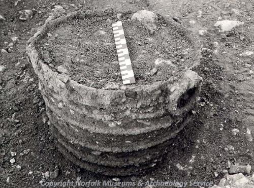
An Early Saxon iron-bound bucket from Morningthorpe. (© NCC)
An excavation following the chance discovery of two Early Saxon pots in a gravel pit in 1974 revealed an important Early Saxon cemetery (NHER
1120) with about 365 inhumations and nine cremations. Bone preservation was poor due to the acidity of the soil, but the many grave goods recovered included beads, finger rings, iron spearheads, shield bosses, knives, buckles and bucket fragments. Saxon pottery fragments have been recovered elsewhere in the parish (NHER
13955,
14864 and
15473).

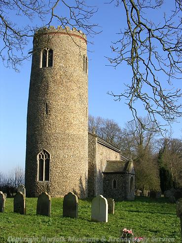
St John the Baptist's Church, Morningthorpe. (© NCC)
The medieval period has left the parish with its oldest surviving buildings, St John the Baptist’s Church (NHER
10167) and St Catherine’s Church (NHER
10186) to the northeast in Fritton. St John’s, situated on the edge of a farmyard, is a neat church consisting of a round west tower, nave, chancel and south porch. Although subject to a comprehensive Victorian restoration, the tower has Saxo-Norman origins and the rest of the church is 14th to 16th century (though the south porch is a Victorian rebuild). The interior of the church is mainly Victorian too, but a good 15th century octagonal font survives, with a piscina and tomb in the chancel from the same period. There is also an interesting assemblage of 16th to 19th century memorials and tombs. In the churchyard are a number of unusual late 19th century gravestones with pointed ogee tops and carved foliage along the edges.
St Catherine’s Church is a round-towered church set in fields. The west tower is 12th century with a 15th century octagonal belfry and a later embattled parapet. The nave north door is also 12th century. The south porch is 15th century. The windows in the nave are perpendicular in style, but these are 19th century replacements. The real treasure of the church is to be found inside; as it was not rebuilt in the late medieval period, it has retained its 15th century wall paintings of St Christopher, St George and a small figure of a young looking bishop. There are also impressive 15th century panel paintings on the screen under the modern rood. The 15th century octagonal font is noticeable for the fact that all the carved lions on it are smiling wildly.
Island House (NHER 3995) stands within an early medieval moated site. The south end may be the remnant of a 15th century jettied house with a screens passage, the upper floor having been removed, the south end later altered to form a kitchen, and the north end replaced by a large hall and parlour block in about 1580, at which time the original house was converted to a service range. The new hall was later subdivided; there is a date on the door of 1684, but its relevance is not known. In the 19th century the building was reduced in height at the south end, given a new roof, and probably subdivided into cottages, before being renovated and extended in the 20th century.
Fritton Hall (NHER 3994) is a small timber framed manor house dating to before the middle of the 16th century, with a grand west gable and a large south wing added in about 1600, giving the building an L shaped plan. A late 19th century porch sits in the angle. To the north and south of the house are 17th to 18th century barns.
Other medieval buildings have not survived. To the north of the parish is the site of Boyland medieval village (NHER 10168), all trace of which has now gone. This site was also home to successive Boyland Halls, the last of which was built in 1571 and remodelled in the Gothic Revival style in 1804. After the death of the last owner in 1930, the hall stood empty until it was demolished in 1947. A 16th century brick culvert still carries a stream under the site. Planning permission was granted in 2003 for a large new house to be built.
Medieval finds include pottery fragments (e.g. NHER 13955, 14316, 14317 and 14650), coins (e.g. NHER 29412) and a gold finger ring set with a sapphire (NHER 30038).
The post medieval period saw the construction of a large number of 17th and 18th century timber framed farm and domestic buildings, far too numerous for the purposes of this summary. With apologies to those whose properties are not included, selected examples include Church Farmhouse on Church Street (NHER 44718) and an identically named house on The Street (NHER 44719), Friars Farmhouse (NHER 44721) and its barn (NHER 29992), Fritton Rectory (NHER 44722), The Three Nags Public House on Fritton Common (NHER 44733), Moor Farm on Morningthorpe Green (NHER 41972) and nearby Blacksmith’s Cottage (NHER 44716). These buildings are a random sample and have not been singled out as having any greater merit than others of the period.
The Rectory (NHER 44731) is 17th to 18th century, Little Friars on Church Street (NHER 44724) is late 18th century and of brick and The Hollies on Tasburgh Road (NHER 44730) is early 19th century, also of brick.
More chronologically recent entries on the record are a type K6 telephone box (NHER 44723) on Fritton Common, built to a 1935 design by Sir Giles Gilbert Scott, and a World War Two anti-tank mortar base (NHER 33311) on the edge of the Common.
Piet Aldridge (NLA), 16 October 2006.
Further Reading
Morris, J. (General Editor), 1984. Domesday Book (Chichester, Phillimore & Co)
Rye, J., 1991. A Popular Guide to Norfolk Place Names (Dereham, The Larks Press)