This Parish Summary is an overview of the large amount of information held for the parish, and only selected examples of sites and finds in each period are given. It has been beyond the scope of the project to carry out detailed research into the historical background, documents, maps or other sources, but we hope that the Parish Summaries will encourage users to refer to the detailed records, and to consult the bibliographical sources referred to below. Feedback and any corrections are welcomed by email to heritage@norfolk.gov.uk
Roydon (near Lynn) is a small parish in the West Norfolk local government district, not to be confused with Roydon near Diss, in the South Norfolk local government district. Roydon Common, an area of heath and woodland, dominates the south and west of the parish, and contains a nature reserve and trail. The village of Roydon is situated to the east, and the parish is cut by the remains of the east to west line of the Midland and Great Northern Joint Railway (NHER 13581). The name Roydon is thought to have evolved from the Old English words for ‘Rye Hill’.
The survival of Roydon common has meant that unlike many other parishes, Roydon does not have a large number of arable fields. In addition, Roydon village has not undergone any recent domestic or industrial expansion. Both of these circumstances have resulted in the identification of very few objects or sites, and the total records for the parish number only twenty-two.

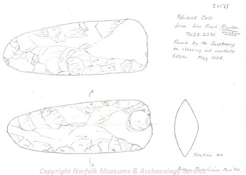
A Neolithic part-polished axehead found near Roydon, near Lynn. (© NCC)
Of these, there are five examples of prehistoric flint work. This includes flint flakes (NHER
3315), two polished flint axeheads (NHER
16950, NHER
20561), and a perforated stone axehammer (NHER
3571). The continued existence of the common has however resulted in the preservation of three Bronze Age round barrows, situated between 800m (NHER
11289) and 700m (NHER
11290, NHER
11291) from Hall Farm.
These features are situated around a south-facing scarp, overlooking a minor local road. The barrows vary between 1m to 1.5m high, covering 20m to 30m in diameter. Although these features are largely overgrown with bracken and saplings, they offer a rare chance to see features from the Bronze Age period in a local landscape largely untouched since that period.
The largest and most prominent of the barrows (NHER 11289) is situated on a slight knoll above the scarp, with the other two smaller barrows (NHER 11290, NHER 11291) 70m away on the edge of the scarp. Although we do not know whether they were constructed at the same time or whether the same people were responsible for all three monuments, it seems likely that these features are related.
The lack of arable land has particularly hampered metal detecting activities, which are the most common source of information on coins, metal objects and pottery for the Iron Age to Saxon periods. As a result, a single pottery sherd (NHER 3316) and an Iron Age or Roman terret ring (NHER 32764) are the only objects from the Roman period, and two examples of Late Saxon to medieval pottery sherds (NHER 3572, NHER 16819) are the only finds with a Saxon origin.
Roydon does feature in the Domesday Book, and interestingly there is mention of salt-houses, although no evidence for these has yet been recovered. The entry for Roydon is brief and it is therefore not surprising that there are only two sites of confirmed medieval origin. At the heart of the parish is the church of All Saints (NHER 3344), which has Norman north and south doorways. The west tower is also early, dating to around 1300 with quatrefoil lights, angle buttresses and putlog holes topped with massive stone slabs. The remainder of the church is reluctantly neo-Norman, a product of the restoration under G. E. Street in 1857. He is also responsible for the Y-tracery west window and the Y-tracery bell openings in the tower. Outside the church was given Victorian trimmings of red stone, and inside the font and pulpit also date from this restoration.
The Rey site (NHER 3317) would also have been of importance in the life of the village. The Rey is a moated manor site, originally constructed around 1400 by John Wodehouse, and according to William of Worcester demolished in 1454 by Lord Scales because of land disputes, the materials being used to build Middleton Towers. A licence to crenellate and empark was issued in 1447 for this site to Thomas Daniel, King's squire, suggesting that following the destruction of the original by Lord Scales the manor was rebuilt.
The rectangular moat was recorded by the Ordnance Survey on their early maps, but 1974 aerial photographs show only two sides remaining, and the third visible as cropmark. A site visit in 1979 recorded that the moat had been completely destroyed. Analysis of the aerial photography indicates that the main moat was also surrounded by several rectilinear enclosures and associated linear features. These may have been related to the layout of buildings and gardens associated with the manor. Unfortunately only a handful of coins and pottery sherds have survived from any of the buildings that once stood on this site.

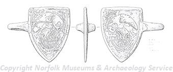
A medieval horse harness pendant depicting a pelican found in Roydon near Lynn. (© NCC)
Medieval and post medieval objects are usually common finds, owing to the metal detecting work undertaken by members of the public, but in Roydon only two areas of medieval finds have been recorded. These are both situated in or near to the village (NHER
16818, NHER
32764). The fact that a number of medieval and post medieval metal objects and coins were recovered from one of these areas, the only area to have been subject to metal detecting, indicates that this parish is not bereft of archaeological evidence, rather that it awaits investigation.
Also dating to the post medieval period is Hall Farmhouse (NHER 46809), an 18th century house noted by English Heritage for its architectural interest. Evidence of more recent activity can be found in the form of the east to west line of the Midland and Great Northern Joint Railway, a line that linked Great Yarmouth to Sutton Bridge through Stalham, North Walsham, Aylsham, Melton Constable, Fakenham and King’s Lynn. The line opened in stages between 1865 and 1933, and although it is now closed, the remains of the embankments, and some of the associated buildings still remain visible in some areas. Even more recently, the military activity of World War Two has left the earthworks of a bomb target (NHER 12833) visible in the very western corner of Roydon Common.
Ruth Fillery-Travis (NLA), 13 February 2007.
Further Reading
Morris, J. (General Editor), 1984. Domesday Book, 33 Norfolk, Part I and Part II (Chichester, Phillimore & Co)
Rye, J., 1991. A Popular Guide to Norfolk Place Names (Dereham, The Larks Press)