This Parish Summary is an overview of the large amount of information held for the parish, and only selected examples of sites and finds in each period are given. It has been beyond the scope of the project to carry out detailed research into the historical background, documents, maps or other sources, but we hope that the Parish Summaries will encourage users to refer to the detailed records, and to consult the bibliographical sources referred to below. Feedback and any corrections are welcomed by email to heritage@norfolk.gov.uk
Necton is in the Breckland district of Norfolk. The parish is south of Little Dunham and north of Holme Hale. The village is just south of the A47. The village name derives from old English and means ‘ farmstead on or by a neck of land or ridge’. There has been little archaeological investigation in the parish with only fifty seven records in the database.

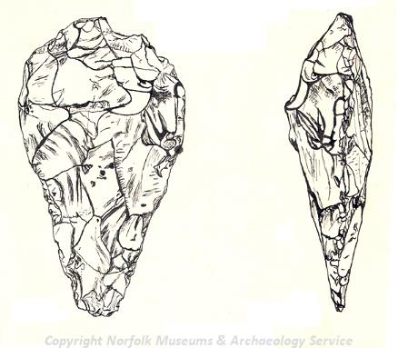
A Palaeolithic flint handaxe. (© NCC)
The earliest object recorded in the database is a Palaeolithic flint handaxe (NHER
4599) found in 1966 north of Town Farm. Several Neolithic worked flints have also been recovered including an arrowhead (NHER
4600), an axehead (NHER
4601) and a Neolithic to Bronze Age stone mallet (NHER
4602). Many of these objects were recovered in the 19th century. The mallet head was found before 1828. A possible hoard of Middle Bronze Age metal objects (NHER
2664) was found in 1849. The hoard comprised two spearheads, a chisel, a flanged axehead and a palstave.
The cropmarks of several possible Bronze Age ring ditches (NHER 11890 and 30321) have been identified on aerial photographs. These cropmarks are all that remain of a burial mound surrounded by a ditch. Ploughing and/or excavation has destroyed the mound and only the outline of the ditch can be seen. Mona Hill (NHER 4603) is an example of a surviving Bronze Age round barrow. The burial mound has not been excavated although one record suggests that 'several ornaments and arms' have been found here. Two possible prehistoric burnt mounds (NHER 31854 and 33712) have also been identified. The exact date and function of these mounds of burnt stones are unclear, but the stones may have been used to heat water for cooking.
An Iron Age silver East Anglian coin (NHER 34673) was found. It depicts a face on one side and a horse on the other. Single Roman coins have also been found (NHER 4604 and 4605). A scatter of Roman material including coins, pottery and fragments of quern stone (NHER 30424) has also been recovered. Metal detecting on the same site found two lead steelyard weights, a possible Roman brooch and a Roman helmeted bust from a figurine. The large number of finds suggests this might be the site of a small Roman settlement. A Roman road from North Pickenham to Toftrees (NHER 3697) passes through the parish but is some distance from the potential settlement. This road is indicated in the alignment of a series of roads, field and parish boundaries. Pieces of Roman pot (NHER 15726 and 34673) and a Roman brooch (NHER 39912) are also indicative of activity in the area.
There is very little evidence for Saxon Necton. Pieces of Late Saxon pot have been recovered from several sites (NHER 4186 and 8698) including the churchyard (NHER 4642). This suggests that the centre of Saxon settlement may have been located close to the present medieval church, but this is not certain. Land in the parish is recorded in the Domesday Book as being held by Ralph of Tosny. The book is a census of the population and resources of the country and seems to reveal that Necton was rather wealthy. Ralph held woodland for 1000 pigs, 290 acres of meadow, a mill, a salthouse, nineteen head of cattle, 100 pigs, 105 sheep and eighty goats. A church is also recorded. The manor at Necton had several outliers (or land owned by the manor removed from the main estate) at Carbrooke, Fransham, Dunham, Godwick, Shingham, East Walton, Acre, East Winch, Ickburgh, Breckles and Wretham. The documentary evidence points to Necton being an important and wealthy holding in the Saxon period.
In the medieval period settlement seems to be more widespread than at present. Lodge Cottage, Ivy Todd (NHER 17142) started as a medieval hall house but has now been significantly altered. In addition to medieval settlement in the modern village the earthworks of Pinkneys or Sparham deserted medieval village (NHER 4186) can be seen in the north of the parish west of Sparham Hall (NHER 4209). A well and the foundation of a wall were discovered here along with pieces of Late Saxon and 12th to 13th century pot. Other evidence for settlement was found when a plough hit the foundations of a building (NHER 8698). Other finds from this site include pieces of Late Saxon and medieval pot, part of a quern, an iron blade and many animal bones including those of sheep, horse, pig and ox. A third focus of settlement has been recorded on the common edge where a house is first mentioned on the site in 1361. Fieldwalking on the site has recovered prehistoric flints and pottery dating from the Iron Age to the post medieval periods (NHER 23089).

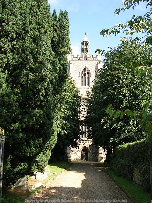
All Saints' Church, Necton. (© NCC)
In addition to settlement evidence two possible medieval moats (NHER
4190 and
4204) have been recorded. Cropmarks of a medieval open field system (NHER
33816) can be seen on an aerial photograph. All Saints’ Church (NHER
4642) mostly dates to the 14th and 15th century. There is a 14th century table tomb in the churchyard. There is further documentary evidence for more religious structures. In 1326 the chantry chapel of St Katherine’s is recorded (NHER
39462). Slightly later Curtey’s will, dated to around 1500, records the building of a second chantry chapel (NHER
39461). The sites of these two buildings are unknown. The sites of two medieval crosses (NHER
19729 and
29730) are recorded in a document dated to 1427.
Interestingly a medieval coin of the Bishops of Toul, Thomas de Bourlement, made between 1330 and 1353 in the empire of Lotharingia was found in the garden of Nani-Tal (NHER 18439). This unusual find had travelled all the way from the large kingdom which comprised the modern countries of The Netherlands, Luxembourg, Belgium and parts of France and Germany to Necton. A medieval French jetton (NHER 30950) was recovered when the turf for the cricket pitch was re-laid. A medieval purse bar loop (NHER 29770) inscribed AVE MARIA GRCIA PLEN and A.DOMINV TECVM was recorded in 1840. A 15th or 16th century painted wooden beam (NHER 32888) has also been found. It is unclear where the beam came from.
Many of the post medieval buildings in the area have been destroyed including Necton Hall (NHER 4633). The hall was built in Elizabethan style with a chapel and was the home of the Mason family since the time of Henry VIII. It was demolished before the 1950s, but the 19th century stables still survive. These probably incorporate an earlier building. The site of an orangery (NHER 4636), garden house (NHER 4634) and icehouse (NHER 4635) probably belonging to the hall are located to the south of the site of the hall itself.
The village used to have two mills. Pickenham Road Mill (NHER 15244) is marked on Faden's map of Norfolk published in 1797. This post mill was last used in 1856. Mill Road mill (NHER 15955) is marked on Faden's map of Norfolk published in 1797. This was a tower mill in the 19th century and was last used in 1904.
The church (NHER 4642) was altered in the 19th century when the roof was repainted and the tower was rebuilt and strengthened to hold two new bells. The south porch was demolished and replaced by a mausoleum by Pugin.
The most recent archaeological record is for a telephone box (NHER 44652) in the village beside the post office. This type K6 cast iron box was designed by Sir Giles Gilbert Scott in 1935.
Megan Dennis (NLA), 20 July 2006.
Further Reading
Neville, J., 2005. ‘Norfolk Mills - Necton tower windmill’. Available:
http://www.norfolkmills.co.uk/Windmills/necton-towermill.html. Accessed: 20 July 2006
Knott, S., 2004. ‘All Saints, Necton’. Available:
http://www.norfolkchurches.co.uk/necton/necton.htm. Accessed: 20 July 2006
Mills, A. D., 1998. Dictionary of English Place Names (Oxford, Oxford University Press)
Brown, P. (ed.), 1984. Domesday Book, 33 Norfolk, Part I and Part II (Chichester, Philimore)
Rye, J., 2000. A Popular Guide to Norfolk Place-names (Dereham, The Larks Press)