This Parish Summary is an overview of the large amount of information held for the parish, and only selected examples of sites and finds in each period are given. It has been beyond the scope of the project to carry out detailed research into the historical background, documents, maps or other sources, but we hope that the Parish Summaries will encourage users to refer to the detailed records, and to consult the bibliographical sources referred to below. Feedback and any corrections are welcomed by email to heritage@norfolk.gov.uk
Kirby Cane is a small parish in the South Norfolk district. It is located between Stockton and Geldeston to the west and Ellingham to the east. The modern village has now grown and almost joins Ellingham. The village name has an interesting derivation. Kirby comes from Old Norse and means ‘land with a church’. The suffix Cane probably relates to the lord of the manor. This may be Walter de Cadamo who is recorded as owning land in 1205 or Maria de Cham who owned the manor in 1245. The surname Cham is French and is probably based on the town name of Caen. Land in the village is recorded in the Domesday Book when the Abbots of St Edmund held part of it. A church and mill are recorded. The village was bypassed in the late 1980s. Fieldwalking before construction of the bypass has enabled us to understand more about the archaeology of the parish.
The earliest recorded archaeological finds are some Mesolithic worked flints (NHER 13331). Neolithic worked flints (NHER 10655) including an axehead (NHER 10656) have also been recovered. The earliest dated sites are two possible Bronze Age ring ditches (NHER 17481 and 17482). These have been identified from cropmarks visible on aerial photographs. Metal detecting has found a Bronze Age copper alloy gouge (NHER 33208).
There are early records of a possible Roman tile kiln (NHER 10657), or a kiln made of Roman tiles found on Pewter Hill. Pieces of pottery, tile and painted wall plaster found in and around a water pipe trench revealed the location of a Roman building (NHER 23325). Cropmarks of a possible Roman temple (NHER 25647) can be seen on aerial photographs but the interpretation of this structure is not clear. Old documents suggest the rectangular shape may be the site of a medieval moat. The discovery of Roman coins (NHER 33208 and 24757) and pottery (NHER 24868 and 23753) are further evidence of activity.

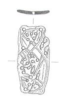
A Late Saxon decorative plaque from Kirby Cane. It is decorated in Scandinavian Ringerike style with an animal in a complicated figure-of-eight. (© NCC)
Early Saxon brooches and other objects were found on Pewter Hill before 1855. Later metal detecting in the area recovered more finds and it is now recognised that this was the site of an Early Saxon inhumation cemetery (NHER
10657,
12380 and
23755). There is very little evidence for Middle Saxon Kirby Cane, but by the Late Saxon period it is clear that there was settlement here. Parts of All Saints’ Church (NHER
10658) may be Saxon. Late Saxon pottery (NHER
12379) has been recovered. A Late Saxon hooked tag (NHER
24947) was found by a metal detectorist and a decorative plate (NHER
32287) made in Scandinavian Ringerike style has also been recorded. The Viking style of this object links closely to the Old Norse place name suggesting there may have been Scandinavian influence in this area.
Parts of the medieval field system (NHER 17335 and 23757) and the edge of a medieval common (NHER 29791) have been recorded. The location of the deserted medieval village of Erwellestun (NHER 19172) is believed to be located in the northwest of the parish although its exact position is unclear. A metal detectorist has found an interesting swivel from a medieval dog leash (NHER 36238). This incredibly decorative object may have been used by a posh medieval lap dog!
Kirby Cane Hall (NHER 10690), a 17th century brick building, has an extensive landscaped park (NHER 29792) around it. The park was designed at the same time as the hall but it tripled in size in the 19th century. Within the park are a two storey garden house (NHER 44217) and some very interesting topiary including a yew walk that leads to the church. The church was remodelled and a vestry was added in the 18th century. Elva House (NHER 21033), a 17th century building, was demolished during the construction of the bypass. Several late Georgian buildings in the village survive – Red Farm House (NHER 12664) and Old Rectory (NHER 12665). The site of a post medieval brick kiln (NHER 15981) is recorded on old maps.
The most recent recorded archaeological sites are possible World War Two trenches (NHER 29792) dug in Kirby Hall Park when military activity took place here.
Megan Dennis (NLA), 3 April 2006.
Further Reading
Brown, P. (ed.), 1984. Domesday Book, 33 Norfolk, Part I and Part II (Chichester, Philimore)
Interment.net, 2006. ‘All Saints’ Norfolk, England’. Available:
http://www.interment.net/data/eng/norfolk/allsaints/index.htm. Accessed: 3 April 2006.
Mills, A. D., 1998. Dictionary of English Place Names (Oxford, Oxford University Press)
Norfolk Federation of Women’s Institutes, 1990. The Norfolk Village Book (Newbury, Countryside Books and Norwich, Norfolk Federation of Women’s Institutes)
Rye, J., 2000. A Popular Guide to Norfolk Place-names (Dereham, The Larks Press)
South Norfolk District Council, 2005. ‘Bike It! Route 7’. Available:
http://www.south-norfolk.gov.uk/leisure/media/Bike_It_route_7_map.pdf. Accessed: 3 April 2006.