This Parish Summary is an overview of the large amount of information held for the parish, and only selected examples of sites and finds in each period are given. It has been beyond the scope of the project to carry out detailed research into the historical background, documents, maps or other sources, but we hope that the Parish Summaries will encourage users to refer to the detailed records, and to consult the bibliographical sources referred to below. Feedback and any corrections are welcomed by email to heritage@norfolk.gov.uk
Please note that this parish summary was compiled in early 2007. Later In 2007, following publication of this article, the parish boundary between Hunstanton and Old Hunstanton was altered ensuring that the village now known as Old Hunstanton is located within Old Hunstanton parish. The article below only discusses the sites located within Old Hunstanton parish prior to the 2007 boundary change. See the parish summary for Hunstanton for information on Old Hunstanton village.
The parish of Old Hunstanton is situated in northwest Norfolk, just inland from coastal New Hunstanton. Its name comes from the Old English for ‘Hunstan’s enclosure’. The parish has a long history and was certainly well established by the time of the Norman Conquest, its population, land ownership and productive resources being extensively detailed in the Domesday Book of 1086.
The earliest dateable evidence of human activity comes in the form of Mesolithic to Neolithic flint scrapers, flakes and cores (NHER 1137, 1138, 1139 and 11246). Neolithic finds include a polished flint axehead (NHER 1392), arrowheads (NHER 14785 and 1112), scrapers (NHER 1140) and a stone macehead (NHER 1149). A Neolithic flint-working site (NHER 1393) was noted in the south of the parish 1962. Implements found included a partly polished axehead, scrapers, a broken stone macehead and two barbed and tanged arrowheads. Neolithic to Bronze Age flint-working sites were noted in fields further north after ploughing in 1978 (NHER 17964, 17965 and 17966).
The Bronze Age has left traces of the earliest structures. The cropmark of a ring ditch or Bronze Age barrow (NHER 1263) is visible on aerial photographs to the west of the parish. The barrow was excavated in 1968, and objects recovered include a Bronze Age urn, an incense cup, a scraper, a naturally holed flint and a bronze awl. A second urn was found inverted over the cremation. Part of a stone axe-hammer (NHER 1264) from the same period was found nearby. Other possible ring ditches have been identified from aerial photographs (NHER 18824, 24410, 26942 and 26953). An Early Bronze Age decorated pottery vessel and a female skeleton were found during sand extraction works in the south of the parish in 1972 (NHER 12736).
Iron Age finds to date include an Iceni silver coin (NHER 21714) pottery fragments, a bead and a piece of tankard handle (NHER 1270). From this latter site, known as Renaut’s Field, a spread of Roman material, including pottery fragments, roof and flue tiles and oyster shells was noted as far back as 1952, indicating the former presence of a Roman building. From the mid 1980s to date, much further Roman material has been recovered, mainly by metal detecting. Objects found include coins, brooches, a bracelet and pottery fragments. Other Roman finds in the parish include pottery fragments (NHER 21714 and NHER 1268), coins (NHER 29563 and 34617) and brooches (NHER 22965 and 34413).
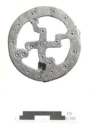
An Early Saxon brooch from Old Hunstanton. (© NCC)
To the east, an Early Saxon inhumation cemetery (NHER 1142) located on the top of a glacial esker was discovered in 1860 and excavated between 1900 and 1902. A further burial was excavated in 1969. The grave goods found with the burials include spearheads, knives, shield bosses, brooches and beads. Other Saxon finds include pottery fragments (NHER 21714 and 29336), a tag and strap end (NHER 29563), a brooch (NHER 34414) and a coin (NHER 34617).
The medieval period has left the parish with its oldest surviving building, St Mary’s Church (NHER 1136). Old Hunstanton is dominated by Hunstanton Hall (NHER 1117), and in its grounds is St Mary's, one of the biggest churches in this part of Norfolk. The earliest elements of the church are the Norman font and a fragment of re-used Norman stone in the vestry. The offset northwest tower is 15th century, but is completely dwarfed by the huge nave and chancel, the result of a massive and enthusiastic Victorian restoration and rebuilding exercise that included the fine tall south porch. Inside, the Norman font is set on a high pedestal in a sea of glazed 19th century tiles and the whole interior is lit by very good 19th century stained glass windows. The east window is particularly fine. St Mary's is not without its medieval survivals, including the rood screen and the arcades, but the overall feeling is of 19th century confidence, epitomised by the splendid carved alabaster pulpit, made as a memorial to Henry Styleman Le Strange (died 1862), who paid for all the rebuilding work.
In the churchyard are two headstones of 1784, one to an Excise man killed by smugglers and one to a smuggler who fell in the same skirmish.
Two medieval crosses once stood in the parish. One (NHER 1280) marked on a map of 1615 has now gone, but another (NHER 19185) that stood on Gipsy’s Green was moved during the 19th century and now stands at Hunstanton Green (NHER 1279).
Hunstanton Hall (NHER 1117) is one of the great houses of Norfolk, this was the mansion of the L'Estrange family (the name was changed to Le Strange in 1839 and adopted by the Stylemans, who inherited in 1760). P.G. Wodehouse was a frequent visitor in the 1920s and 1930s and the house is featured in some of his stories. The moated site surrounds buildings which are said to have 14th century cores and a gatehouse of 1487. The hall was rebuilt in 1618, and the side ranges in 1623, with a wall along the moat dated 1622. The Octagon is of 1640 and the formal gardens after 1686. There were fires in 1835 and 1853, followed in each case by rebuilding, with further work in the 1870s and up to 1900. A third fire followed in 1950. The wing north of the gatehouse that was gutted by the 1950 fire was restored in the 1980s.
The walled and moated gardens of the surrounding Hunstanton Park (NHER 30464) developed from the 16th century onwards, within an area that originated as a deer park in the 15th century. It was embellished in the 17th century and was greatly extended in the 19th century.
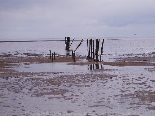
A group of timber posts of unknown date. (© NCC)
Other medieval structures have not survived, including Barret Ringstead or Ringstead Parva medieval settlement (NHER 1115). This village was probably abandoned after the Black Death of 1348-9, and the earthworks of its buildings and streets can now only be seen as cropmarks from the air. The village’s chapel, now an overgrown ruin, is all that remains above the ground.
Medieval finds include pottery fragments (for example NHER 1116, NHER 1587 and NHER 29336), buckles (NHER 21714), jettons (NHER 29563) and a lead weight (NHER 34617).
Buildings of the post medieval period include Park House (NHER 9040) in Hunstanton Park. This is a small square two storey building of brick, chalk and carrstone, built in 1623 as a deer keeper's house. Later alterations include the blocking of some windows. It is possible that it was later used as a dovecote.
Downs Farm (NHER 31002) in Barrett Ringstead is a farmhouse dated 1714 and 1754 and a barn dated 1717. These form two sides of a yard, the third side consisting of a stable block converted to pig sties with an 18th century granary over a cart lodge of eight bays and two builds. Together, these buildings are an unusual survival.
Nos 62 and 63 Church Street (NHER 47096) form a single 17th century and later two storey clunch, rubble and brick house, now two dwellings, with a red pantile roof and an 18th century addition to the south that forms number 63. Number 66 (NHER 46916) is a late 17th or early 18th century two storey clunch and brick cottage with a red pantile roof and a single storey lean-to at the north. The later south brick gable has a monogram and a date stone of 1788.
The most historically recent entry on the record is Smithdon High School (NHER 29696) on King’s Lynn Road, a 1954 secondary school by Alison and Peter Smithson. Built of steel and glass panels around two courtyards, it is a pioneering design of international importance.
Piet Aldridge (NLA), 8 February 2007.
Further Reading
Brown, P. (Ed.), 1984. Domesday Book: Norfolk (Chichester, Phillimore & Co)
Rye, J., 1991. A Popular Guide to Norfolk Place Names (Dereham, The Larks Press)