This Parish Summary is an overview of the large amount of information held for the parish, and only selected examples of sites and finds in each period are given. It has been beyond the scope of the project to carry out detailed research into the historical background, documents, maps or other sources, but we hope that the Parish Summaries will encourage users to refer to the detailed records, and to consult the bibliographical sources referred to below. Feedback and any corrections are welcomed by email to heritage@norfolk.gov.uk
Foulden is a parish in the south of Norfolk and is considered part of the Breckland district. It lies south of Gooderstone and north of Didlington. The River Wissey runs roughly west to east through the parish and the modern village sits overlooking the valley. Around the river some areas of fen (known as Borough Fen) survive and Foulden Common is a large expanse of land in the north of the parish. Some of the parish is now planted with conifers and is part of Thetford Forest managed by the Forestry Commission. The village name derives from old English and probably means 'hill frequented by birds'. The Old English derivation suggests the village was settled during the Saxon period, and by the date of the Domesday Book in 1086 the village seems to have been relatively large supporting a mill and two fisheries. Archaeological work in the landscape suggests that there was human activity in the area much earlier than this, however. Surveys before tree destumping by the Forestry Commission, excavations before development, metal detecting and casual finds have revealed an archaeological record stretching back to the Neolithic period.
The earliest finds include a Neolithic arrowhead (NHER 34052) and other Neolithic worked flints. Other prehistoric finds, such as the scatter of prehistoric burnt flints (NHER 4583) on Foulden Common may date back this far, or even earlier, but they are very difficult to date accurately. Prehistoric gullies (NHER 37611), excavated before a new house was built, were also difficult to date because they contained very few finds. A human jaw (NHER 4735) found in Borough Fen may be Bronze Age.

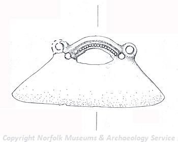
A Bronze Age or Iron Age razor made of copper alloy. (© NCC.)
Other Bronze Age finds, such as fragments of a Bronze Age rapier (NHER
29773,
29774 and
29880) and a Late Bronze Age decorated razor and rapier (NHER
17292) found by a metal detectorists are easier to identify. These Bronze Age finds are concentrated around the area of the River Wissey and this suggests that this was the location of a focus of activity. It is close to the river where a possible Bronze Age ring ditch (NHER
35574), the remains of a round barrow, have been identified from aerial photographs. The numbers of Bronze Age metal finds from one site, plus the presence of worked flints of the same period, suggest this could be an area worth more investigation. At the same site a number of Iron Age finds, including two Iron Age copper alloy pins (NHER
17292) were also recovered. Reports of the discovery of two Iron Age torc terminals (NHER
21198) in Foulden may, however, be misleading.
Although several Roman finds have been made in the area there is no clear evidence for Roman settlement. Fragments of Roman pottery (NHER 37611) and two Roman brooches (NHER 21751) have been found. A metal detectorist recovered a Roman stud (NHER 22067) and a Roman ferrule (NHER 29774) was found on another occasion. Fieldwalking and metal detecting on the possible Bronze Age and Iron Age site (NHER 17292) identified above recovered the strongest evidence for a concentration of Roman activity. Fragments of Roman pottery, over fifty Roman coins and a copper alloy Roman cosmetic palette were found here. The coins mostly date to the 3rd and 4th century AD. The discovery of a possible Roman bracelet (NHER 4801) in a gravel pit with Saxon finds suggests that this may be an Early Saxon object or have been deposited in the Early Saxon period.
The bracelet was found on the site of an Early to Middle Saxon inhumation cemetery (NHER 4801). At least seven burials have been found here since the 1930s. One of these was of a man who was buried with his dog. The dog was laid out with his head resting on the man's leg. Other finds include iron knifes and a possible set of shears. A metal detectorist found a 6th century long brooch (NHER 21751) elsewhere. These two records suggests that there was a population settled somewhere in the parish in the Early Saxon period. The evidence is more scanty for the Middle and Late Saxon periods. Four Middle Saxon pins (NHER 22067 and 17292) have been found at two separate locations. Evidence for the Late Saxon period is confined to a coin of King Aethelweard of East Anglia (NHER 29881) who lived around AD 850 and another of a King of Mercia (NHER 21752). A Late Saxon strap end (NHER 17292) with an animal head terminal with a yellow glass inset eye was also found by a metal detectorist.
By the medieval period it is clear that the village of Foulden was settled. The village originally had two churches and therefore must have had quite a large population. The presence of earthworks of medieval enclosures (NHER 12724) that were an area of medieval settlement and a medieval moat (NHER 21184), perhaps the site of Foulden New Hall, outside the modern village reinforce this suggestion. St Edmund's (NHER 4829), located closer to the River Wissey, may mark an earlier focus of settlement that was later abandoned. It is not clear what date St Edmund's church was built and now only a few ruins remain. It is thought the church was abandoned by about 1550 when All Saints' (NHER 4826) in the middle of Foulden village became more important. This switch in focus is interesting, particularly as documents record that St Edmund's was the mother church of All Saints'. All Saints' is mostly 14th century in date. The medieval stone cross (NHER 4822) that used to stand in the village survives and has been moved to Cross Cottages where the base and part of the shaft can still be seen in the garden. The presence of two fisheries in the village is recorded in the Domesday Book and although no archaeological evidence of these sites has been recorded a possible medieval fishpond (NHER 31736) is marked on an old map. Remnants of medieval ridge and furrow (NHER 31910) can also be seen where land was used for agriculture during this period. An interesting medieval find is that of a medieval seal matrix (NHER 40489). These were used to impress wax seals on letters. The inscription on this matrix identifies it as the property of William, Rector of Kirkby on Bain, Lincolnshire. Perhaps he was in Foulden visiting a friend or on his holidays when he lost his matrix.

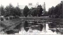
Foulden Hall dates from the late 16th century. This photo was taken around 1900.
Foulden Hall (NHER
4828) is a late 16th century building which was considerably altered and extended in the Victorian period. It was built with its own defensive moat, part of which still survives, and there was a watermill (NHER
16711) nearby which pumped water to the hall and drove machinery in a nearby barn. These structures are still standing and the watermill has recently been restored. Other post medieval buildings have been lost and the only record of Foulden windmill (NHER
37151) is its location marked on a map of 1826. More recent buildings are also of interest. A 19th century limekiln (NHER
16682) identified by the Norfolk Industrial Archaeology Society is an unusual type with no underground chamber, one firing chute and no coverings, leaving it open to the elements.
Megan Dennis (NLA), 8th December 2005.
Further Reading
Brown, P. (ed.), 1984. Domesday Book, 33 Norfolk, Part I and Part II (Chichester, Phillimore)
Mills, A.D., 1998. Dictionary of English Place Names (Oxford, Oxford University Press)
Neville, J., 2004. 'Norfolk Mills - Foulden Watermill'. Available:
http://www.norfolkmills.co.uk/Watermills/foulden.html. Accessed: 8 December 2005.
Rye, J., 2000. A Popular Guide to Norfolk Place-names (Dereham, The Larks Press)