This Parish Summary is an overview of the large amount of information held for the parish, and only selected examples of sites and finds in each period are given. It has been beyond the scope of the project to carry out detailed research into the historical background, documents, maps or other sources, but we hope that the Parish Summaries will encourage users to refer to the detailed records, and to consult the bibliographical sources referred to below. Feedback and any corrections are welcomed by email to heritage@norfolk.gov.uk
Brumstead, or Brunstead as it is known locally and often written on old maps, is a small parish in the Broadland district of Norfolk. Nestled west of Ingham and east and north of East Ruston the village is also very close to the Norfolk coast. The earliest documentary source to mention the village is the Domesday Book which describes it as the land of Roger Bigot, and mentions that there is a church and a mill as well as thirty goats. The name means ‘broom covered place’ and comes from Old English, indicating a Saxon origin. Although Brumstead is not a very large parish there has been a fieldwalking survey and metal detecting here which has helped to develop a clearer understanding of human activity here in the past.

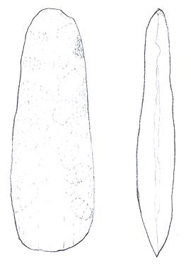
Neolithic polished axehead from Brumstead. (©NCC)
The earliest evidence comes from the Neolithic period. Several Neolithic flint axeheads (NHER
24036 and
8223) have been recovered in the parish and a Late Neolithic or Early Bronze Age thumb nail scraper (NHER
35227) was also found here. Other prehistoric flints recovered from the parish during fieldwalking ahead of the Bacton to Great Yarmouth gas pipeline were concentrated on the higher land in the middle of the parish. A Late Bronze Age socketed axe (NHER
36626) was found by metal detecting, whilst a Bronze Age round barrow (NHER
38531) has been identified from aerial photographs. A double ring ditch (NHER
38602) may also be Bronze Age, although this isn’t clear. Early records show that an Iron Age gold coin (NHER
8224) from the northeast of Britain was found here in 1875. There is also evidence for Iron Age or Roman field boundaries (NHER
38530) in the parish. These demonstrate that the area was used for agriculture at this period.
This agricultural use of the landscape continued into the Roman period. Analysis of aerial photographs for the National Mapping Project have identified a possible Roman farmstead and associated enclosures (NHER 38536) where Roman pottery (NHER 17674) has also been recovered. Evidence for Saxon activity is sparser. Single finds of Middle Saxon pottery (NHER 28336 and 39632) and an Early Saxon brooch (NHER 36626) have been made within the parish. This absence of archaeology does not however mean that there was no activity here in the Saxon period, but reflects the fact that Saxon archaeology is hard to detect without excavation.
There is more evidence for occupation in the medieval period. Brunstead Hall (NHER 22904) is a 15th century medieval hall now covered by a 19th century façade. The possible site of Le Parkes’ manor house has also been identified at Moat Hill plantation where a medieval moat (NHER 1072) can be seen on aerial photographs. These manors controlled swathes of agricultural land that was divided up by medieval field boundaries (NHER 38535 and 38536). St Peter’s church (NHER 8254) dates from the early 14th century although it has been heavily restored in the 19th century. To the west of the church there is evidence for medieval occupation (NHER 17674) - buildings and enclosures around a post mill. There are also scatters of medieval pottery across the parish that suggest the village may have been much larger in the medieval period than it is now.
In the post medieval period much of the landscape was extensively managed to provide water meadows (NHER 38442, 38443 and 38451). Excavations have also revealed part of a post medieval wall (NHER 8225) that was used as a field boundary. Aerial photographs have revealed the most modern archaeology in the parish – a possible World War Two gun and searchlight emplacement (NHER 38590).
Megan Dennis (NLA), 13th October 2005.
Further Reading
Brown, P. (ed.), 1984. Domesday Book, 33 Norfolk, Part I and Part II (Chichester, Philimore)
Mills, A.D., 1998. Dictionary of English Place Names (Oxford, Oxford University Press)
Rye, J., 2000. A Popular Guide to Norfolk Place-names (Dereham,The Larks Press)
Wilcox, W., 2005. ‘Brumstead History’. Available:
http://www.wilcox53.freeserve.co.uk/BRUMSTEAD%20HISTORY%20MENU.htm. Accessed: 17 February 2006.