This Parish Summary is an overview of the large amount of information held for the parish, and only selected examples of sites and finds in each period are given. It has been beyond the scope of the project to carry out detailed research into the historical background, documents, maps or other sources, but we hope that the Parish Summaries will encourage users to refer to the detailed records, and to consult the bibliographical sources referred to below. Feedback and any corrections are welcomed by email to heritage@norfolk.gov.uk
Bracon Ash, to the southwest of Norwich, is a parish dominated by fairly scattered settlement, grouped around several former greens and commons. Bracon Ash comes from the Old English for ‘bracken’ and ‘ash trees’, and the small hamlet of Hethel means ‘a hill overgrown with heather’. Interestingly these place names refer to a heathland landscape, although the parish is situated on the boulder clay plateau, with its characteristic undulating countryside, small woods and medieval moats.
There is some evidence for early occupation in the parish, several flint implements, including Palaeolithic flakes (NHER 9486), and a Neolithic scraper (NHER 30071) have been found scattered through the parish. The sites of two ring ditches (NHER 36348), probably dating to the Bronze Age, are visible as cropmarks on aerial photographs, and a Bronze Age socketed axehead (NHER 9498) had been found, as well as part of a chain (NHER 31283) which may date to the Bronze Age.
Metal detecting has recovered a number of Roman finds throughout the parish, but these are concentrated in the south, suggesting that this is where the focus of settlement was during the Roman period. Roman coins and pottery (NHER 30204), brooches (NHER 28735), a bracelet (NHER 29310), part of a harness (NHER 29899) and other metalwork have been found.
Bracon Ash itself was a recorded as a small settlement in the Domesday Book, whilst the neighbouring settlement of Hethel was much larger and wealthier, even though it has virtually disappeared today. Hethel had a church and a mill, as well as outlying settlements that belonged to the manor, such as Keswick, meaning ‘cheese farm’, suggesting that Hethel was once the centre of a much larger estate before the creation of the manorial system in the Middle and Late Saxon period. The number of Early Saxon brooches that have been found suggest the presence of a Saxon cemetery in the parish. Late Saxon coins (NHER 29900), harnesses (NHER 21579), and part of a Late Saxon sword as well as pottery (NHER 30392), have been found by metal detecting.
The church listed in the Domesday Book is All Saints’ in Hethel (NHER 9523), which retains its Late Saxon round tower despite substantial alterations in the medieval period. The site of the village of Hethel (NHER 9497) is close to the church, and a medieval moated site (NHER 9507), and the remains of the settlement are visible as surface marks. Moat House (NHER 9505) is an 18th century house surrounded by a medieval moat and a further moated outer enclosure.
St Nicolas’ Church (NHER 9524) in Bracon Ash dates mainly to the 13th century, and the village may once have been gathered around the church, but as the settlement developed through the medieval period, the focus of settlement gradually shifted to the edges of several greens and commons in the parish. Some early houses are still standing in the village, such as the 16th century former open hall house in Hawkes Lane (NHER 20984), and the 16th century farmhouse at Mergate Farm (NHER 36536).
The prosperity of the parish in the post medieval period was mainly due to agriculture, and several large houses, and farms were built during the 17th and 18th centuries. Hethel Hall (NHER 9508) has now vanished from the landscape, but the house probably dated to the 17th century or earlier. An E shaped moat still survives at the site of the Hall, and was probably an ornamental garden feature dating from the 17th century, or perhaps earlier. Mergate Hall (NHER 9992) is also a 17th century Hall, probably on the site of an earlier building. Bracon Hall (NHER 9509) is an 18th century house, as is Bracon Lodge (NHER 9998). Mergate Hall Cottages (NHER 45900) are built of clay lump and date back to the 18th century. The cottages were originally a single house and have now been divided into two.

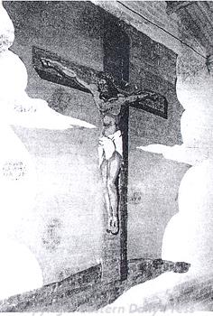
World War Two American forces mural of the Crucifixion in the chapel of Hethel Airfield, Bracon Ash and Ketteringham.
© Eastern Daily Press.
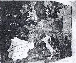
During World War Two the USAAF used Hethel Airfield (NHER
9522), and the runways and buildings of the airfield still survive, although the site is now the Lotus manufacturing plant. A Roman Catholic chapel on the airfield contains murals painted by American airmen.

World War Two American forces mural of map of the world in the Sunday School of Hethel Airfield, Bracon Ash and Ketteringham.
© Eastern Daily Press.
The Hethel Thorn (NHER
9504) is perhaps the most evocative witness of the history of the parish. It was first mentioned in the 13th century, and the tree is now over 700 years old, having seen all the changes that have taken place in the parish over that time. Trees and hedgerows are still a living part of the historic landscape, and they are an important, but sometimes neglected part of the archaeological record.
Sarah Spooner (NLA), 13 September 2005.
Further Reading
Brown, P. (ed.), 1984. Domesday Book: Norfolk (Chichester, Phillimore)
Mills, A.D., 1998. Dictionary of English Place-Names (Oxford, Oxford University Press)
Rye, J., 1991. A Popular Guide to Norfolk Place-names (Dereham, Larks Press)